 Wawa-news.com Local and Regional News
Northeast Region: Updated: June 7, 2026 at 6:30 p.m. EDT There were two new wildland fires confirmed in the Northeast Region today. Sudbury 10 (SUD010) is a 0.2 hectare fire located on the north shore of Agnew Lake. This fire is not under control. Timmins 12 (TIM012) is a 0.5 hectare fire located 1 kilometre southwest of Kaneki Lake. This ...
Read More »Weather, Closures, Forest Fires
Northeast Forest Fire Region Update – June 5
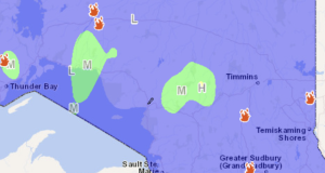
Northeast Region: Updated: June 5, 2026 at 8:15 p.m. EDT There were no wildland fires confirmed in the Northeast Region today: At the time of this update, there are 6 active wildland fires in the Northeast Region. Of those fires, 2 are not under control, 1 is being held, and 3 are under control. Fire of Note Timmins 9 (TIM009) ...
Read More »Northeast Forest Fire Region Update – June 4
Northeast Region: Updated: June 4, 2026 at 8:00 p.m. EDT There was 1 wildland fire confirmed in the Northeast Region today: Cochrane 6 (COC006) was a 0.3 hectare fire that was located at the confluence of the Low Bush River and the Circle River. This fire is out. At the time of this update, there are 8 active wildland fires in ...
Read More »Fire Bans
Timmins (Thursday, June 4th at 9:29 a.m.) Town of Northeastern Manitoulin and the Islands (June 04, 2026, 10:11 AM) Espanola (June 3rd, 2026) Espanola Effective immediately, the lighting of fires in all areas and boundaries of the Town of Espanola is prohibited. During a total fire ban no person shall light, or allow to remain alight, any fire in an ...
Read More »Northeast Forest Fire Region Update – as of 21:25 June 3
Northeast Region: There were 6 wildland fires confirmed in the Northeast Region today: Sudbury 7 (SUD007) was 0.1 hectares and is now out. This fire was located on the west side of Graveyard Lake. Sudbury 8 (SUD008) is a 30 hectare fire located less than a kilometre east of Shank Lake. This fire is not under control. Sudbury 9 (SUD009) ...
Read More »Hwy 144 (between Mattagami Lake Road, Mattagami and HWY 661-Gogama Road, Gogama) OPEN
Jun 4, 2026 at 18:00 At 17:11 the highway was reopened. Jun 3, 2026 at 23:02 A forest fire has closed Hwy 144 between Mattagami Lake Road, Mattagami and HWY 661-Gogama Road, Gogama. The highway was closed at 9:48 p.m. All lanes are closed. Timmins 9 (TIM009) has been remapped at 1100 hectares in size after an increase in fire ...
Read More »Mattagami First Nation – Mandatory Evacuation Order Issued

Jun 3, 2026 at 17:00 June 3, 2026 4:40 p.m. Mattagami Chief & Council on the advice of the MNR are now REQUIRING all residents of the community to evacuate. The Forest Fire could jump the highway by Tatachikapika. Mattagami First Responders will be going around with the Fire Truck and Loud Speaker notifying all residents who stayed behind to ...
Read More »Northeast Forest Fire Region Update – June 2
Northeast Region: At the time of this update, there are 6 active wildland fires in the Northeast Region. Of those fires, 4 are not under control, 1 is being held, and 1 are under control. There were three wildland fires confirmed in the Northeast Region today: Wawa 3 (WAW003) is 7 hectares in size and is located approximately 1 kilometre ...
Read More »Northeast Forest Fire Region Update – June 1
Northeast Region: At the time of this update, there are 7 active wildland fires in the Northeast Region. Of those fires, 3 are not under control, 1 is being held, and 3 are under control. There were two wildland fire confirmed in the Northeast Region today: Sudbury 5 (SUD005) is 0.1 hectares in size and is located on the southeast ...
Read More »Northeast Forest Fire Region Update – May 31
Northeast Region: At the time of this update, there are 6 active wildland fires in the Northeast Region. Of those fires, 2 is not under control, 1 are being held, and 3 are under control. There were 2 wildland fires confirmed in the Northeast Region today: Cochrane 4 (COC004) was 0.2 of a hectare and is located approximately 0.25 of ...
Read More »Highway 17S (Wawa to Batchawana) OPEN One Lane

Jun 1, 2026 at 04:38 At 23:21, on May 31st, Highway 17 was reopened to one lane on the Old Woman Bay Hill. The eastbound lane and shoulder is closed. May 31, 2026 at 20:07 Travel woes continue for travellers. A collision on Highway 129 has meant that OPP has closed the highway for investigation. The highway is closed in ...
Read More »Travel Woes Continue with Hwy 129 (Sultan – Thessalon) OPEN
Jun 1, 2026 at 04:31 At 3:29 a.m. OPP reopened Hwy 129. Ontario Provincial Police – North East Region fb’d “Hwy. 129 has reopened between Hwy. 17 in Thessalon and Hwy. 667 near Chapleau. We appreciated your patience and understanding during the on-site investigation and clean-up.” May 31, 2026 at 20:07 Travel woes continue for travellers. A collision on Highway ...
Read More »Northeast Forest Fire Region Update – May 28
Northeast Region: At the time of this update, there are 11 active wildland fires in the Northeast Region. Of those fires, 6 are not under control, 3 are under control, 1 is being held, and 1 is out. There were 10 wildland fires confirmed in the Northeast Region today: Wawa 2 (WAW002) is 0.2 of a hectare and located along ...
Read More »Northeast Forest Fire Region Update – May 27
Northeast Region: There was 1 wildland fire confirmed in the Northeast Region today: Haliburton 8 (HAL008) is 3 hectares and located approximately 0.3 of a kilometre south of Red Fox Bay, and 0.3 of a kilometre east of Elva Lane. The fire is not under control. Northwest Region: At the time of this update there are 4 active wildland fires ...
Read More »Northeast Forest Fire Region Update – May 27
Northeast Region: There are no active wildland fires in the Northeast Region today. Northwest Region: At the time of this update there are 3 active wildland fires in the Northwest Region. Of those fires, 1 is under control and 2 is not under control. Two new wildland fires were confirmed in the Northwest Region by the early evening of ...
Read More »