 Wawa-news.com Local and Regional News
Northeast Region Updated: June 21, 2026 at 6:30 p.m. Eastern Daylight Time (EDT) There were no wildland fires confirmed in the Northeast Region today. At the time of this update, there are 2 active wildland fires in the Northeast Region. Of those fires, 1 is under control, and 1 is being observed. Cochrane 7 (COC007) is a 30 hectare fire located approximately 5 ...
Read More »Weather, Closures, Forest Fires
Northeast Forest Fire Region Update – June 19
Northeast Region Updated: June 19, 2026 at 6:00 p.m. Eastern Daylight Time (EDT) There were no wildland fires confirmed in the Northeast Region today. At the time of this update, there are 2 active wildland fires in the Northeast Region. Of those fires, 1 is under control, and 1 is being observed. Cochrane 7 (COC007) is a 30 hectare fire located approximately 5 ...
Read More »LSPP – Gargantua Road Remains Closed
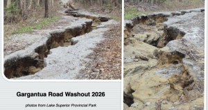
Staff at Lake Superior Park has been hard at work. This year’s spring melt caused washouts throughout the entire region as shown by the many washouts – and continuing closure at Old Woman Bay for a large culvert replacement. The Gargantua Road was also a victim. LSPP relate that “After the snow had melted, we discovered a massive washout, 360 ...
Read More »Northeast Forest Fire Region Update – June 18
Updated: June 18, 2026 at 6:00 p.m. Eastern Daylight Time (EDT) Northeast Region There were no wildland fires confirmed in the Northeast Region today. At the time of this update, there are 2 active wildland fires in the Northeast Region. Of those fires, 1 is under control, and 1 is being observed. Cochrane 7 (COC007) is a 30 hectare fire located approximately 5 ...
Read More »Northeast Forest Fire Region Update – June 17
Northeast Region: Updated: June 17, 2026 at 6:00 p.m. EDT There was one fire reported in the Northeast Region last night after the update: Sudbury 11 (SUD011) was 0.1 hectares in size and located approximately 1 kilometre east of Scar Lake and on the west side of Halifax Rd. This fire is out. There were no wildland fires confirmed in ...
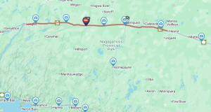
Read More »Hwy 17 (White River to Marathon) OPEN
Jun 18, 2026 at 06:11 ON511 is advising that the highway is now open. Jun 18, 2026 at 05:15 ON511 is advising that Hwy 17 is closed from White River to Marathon due to a collision at the Scenic Lookout – East Entrance. The Marathon Fire Department is currently responding to a call for service on Hwy 17 by the ...
Read More »Northeast Forest Fire Region Update – June 16
Northeast Region: Updated: June 16, 2026 at 6:00 p.m. EDT Northeast Region There were no wildland fires confirmed in the Northeast Region today. At the time of this update, there are 2 active wildland fires in the Northeast Region. Of those fires, 1 is being held, and 1 is being observed. Timmins 9 (TIM009) is 3,151 hectares and located approximately ...
Read More »Northeast Forest Fire Region Update – June 15
Northeast Region: Updated: June 15, 2026 at 6:00 p.m. EDT Northeast Region There were no wildland fires confirmed in the Northeast Region today. At the time of this update, there are 2 active wildland fires in the Northeast Region. Of those fires, 1 is being held, and 1 is being observed. Fire of Note Timmins 9 (TIM009) is 3,151 hectares ...
Read More »Northeast Forest Fire Region Update – June 12
Northeast Region: Updated: June 14, 2026 at 6:25 p.m. EDT Northeast Region There were no wildland fires confirmed in the Northeast Region today. At the time of this update, there are 2 active wildland fires in the Northeast Region. Of those fires, 1 is being held, and 1 is being observed. Fire of Note Timmins 9 is now being held ...
Read More »Northeast Forest Fire Region Update – June 12
Northeast Region: Updated: June 12, 2026 at 6:15 p.m. EDT There were no wildland fires confirmed in the Northeast Region today. At the time of this update, there are 2 active wildland fires in the Northeast Region. Of those fires, 1 is not under control, and 1 is being observed. Fire of Note Timmins 9 (TIM009) was first confirmed on ...
Read More »Northeast Forest Fire Region Update – June 11
Northeast Region: Updated: June 11, 2026 at 6:00 p.m. EDT There was one wildland fire confirmed in the Northeast Region today: Chapleau 6 (CHA006) was 0.1 of a hectare and located approximately 0.1 of a kilometre east of Highway 17 and 3.2 kilometres south of Highway 552. The fire is out. At the time of this update, there are 3 ...
Read More »Northeast Forest Fire Region Update – June 10
Northeast Region: Updated: June 10, 2026 at 6:10 p.m. EDT There were no wildland fires confirmed in the Northeast Region today. At the time of this update, there are 5 active wildland fires in the Northeast Region. Of those fires, 1 is not under control, 1 is being observed, and 3 are under control. Fire of Note Timmins 9 (TIM009) ...
Read More »Northeast Forest Fire Region Update – June 9
Northeast Region: Updated: June 9, 2026 at 6:00 p.m. EDT There was one new wildland fire confirmed in the Northeast Region today: Cochrane 7 (COC007) is 30 hectares in size and located approximately 60 kilometres southwest of Fort Severn. The fire is being observed. At the time of this update, there are 6 active wildland fires in the Northeast Region. ...
Read More »Northeast Forest Fire Region Update – June 8
Northeast Region: Updated: June 8, 2026 at 6:10 p.m. EDT There were two new wildland fires confirmed in the Northeast Region today: Chapleau 5 (CHA005) is 0.1 of a hectare and located on the westside of Highway 17, approximately 0.4 of a kilometre south of Old Highway 17 Road. The fire is under control. Timmins 13 (TIM013) is 3 hectares ...
Read More »Hwy 11 (Longlac to Hearst) OPEN
Highway 11 opened just after midnight. The James Bay Ontario Provincial Police (OPP) is investigating a fatal motor vehicle collision that occurred on Highway 11 in Clavet Township. On June 8, 2026, at approximately 6:45 a.m., members of the James Bay OPP, Cochrane District Emergency Medical Services (EMS) and Geraldton Fire Department responded to a collision involving a commercial motor ...
Read More »