Wawa-news.com Local and Regional News
Northeast Region:
Updated: June 7, 2026 at 6:30 p.m. EDT
There were two new wildland fires confirmed in the Northeast Region today.
- Sudbury 10 (SUD010) is a 0.2 hectare fire located on the north shore of Agnew Lake. This fire is not under control.
- Timmins 12 (TIM012) is a 0.5 hectare fire located 1 kilometre southwest of Kaneki Lake. This fire is not under control.
At the time of this update, there are 7 active wildland fires in the Northeast Region. Of those fires, 3 are not under control, 2 are being held, and 2 are under control.
Fire of Note
- Timmins 9 (TIM009) has been remapped at 3,154 hectares and remains not under control. Timmins 9 was first confirmed on Sunday, May 31 and measures 3,154 hectares. Fifteen Ontario FireRanger crews and a 20-person Incident Management Team are dedicated to this fire. Bucketing helicopters continue to support ground crews, while heavy equipment is constructing control lines in priority areas. Warm and dry weather has returned to the area of Timmins 9, which marks the beginning of a drying trend that is expected to last for the next 2 days.
Updated restrictions in place in the area of Timmins 9
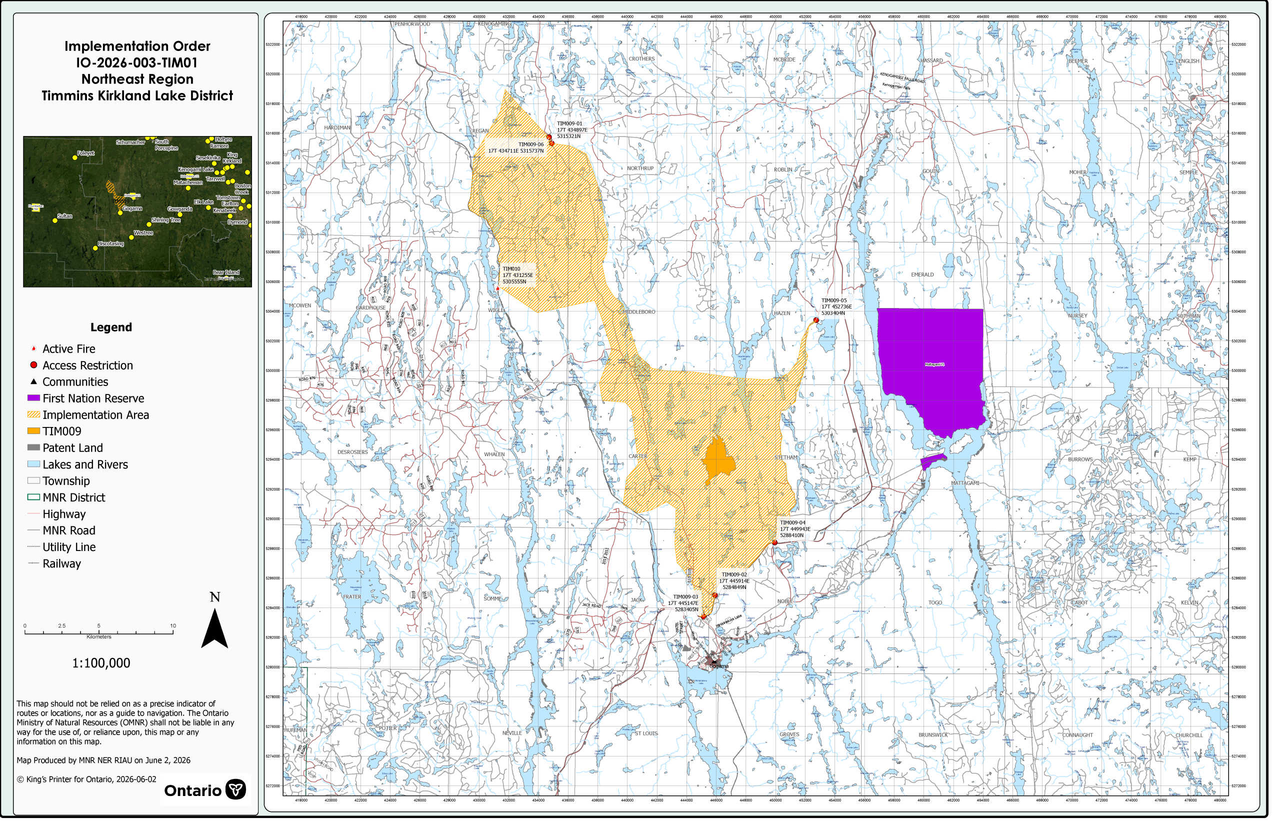
click for larger image
The Ministry of Natural Resources’ Timmins -Kirkland Lake District has invoked an Implementation Order now in effect for the purposes of public safety and fire suppression, for areas near TIM009, under the Emergency Area Order EAO 2026-003 declared on June 2, 2026.
- All travel and use of the Gogama Unit Road starting from Highway 144 (UTM 17T 445914E 5284849N) northbound to the Pineland Road intersection (UTM 17T 439549E 5315737N) as outlined in the attached Implementation Order (IO) map within the Emergency Area Order (EAO), is prohibited unless authorized by an Exemption Permit issued by the Timmins – Kirkland Lake District Ministry of Natural Resources (MNR).
- All travel and use of the trail located behind the Old Vagabond restaurant (UTM 17T 445147E 5283405N) leading to the Gogama Unit Road as outlined in the attached IO map within the EAO, is prohibited unless authorized by an Exemption Permit issued by the Timmins – Kirkland Lake District MNR.
- All travel and use of the Kenetogami Lake Road off Highway 144 (UTM 17T 449943E 5288410N) as outlined in the IO map within the EAO, is prohibited unless authorized by an Exemption Permit issued by the Timmins – Kirkland Lake District MNR.
- All travel and use of the Tatachikapika Lake Road off Highway 144 (UTM 17T 454045E 5308251N) as outlined in the IO map within the EAO, is prohibited unless authorized by an Exemption Permit issued by the Timmins – Kirkland Lake District MNR.
This Order is in effect at 10:01 AM Eastern Daylight Time on June 6, 2026 until such time as the order is revoked.
For exemption permit information, please call 705-235-1300.
NOTAM in effect – Timmins 9
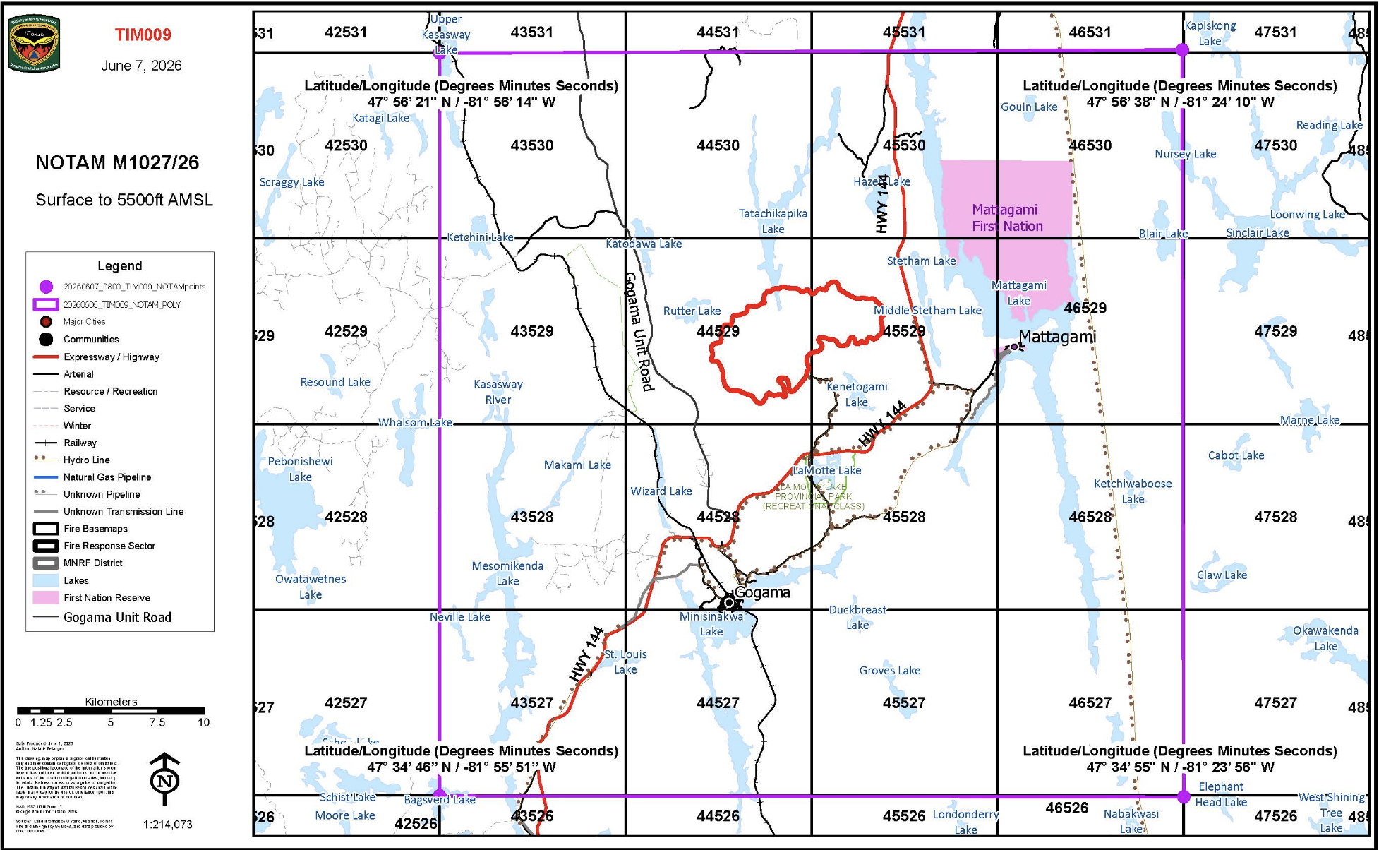 There is currently a NOTAM in the area of wildland fire Timmins 9.
This is over and above the standard airspace restrictions imposed by Section 601.15 of the Canadian Aviation Regulations (CARs) which state that the airspace around all active forest fires is restricted to forest fire suppression aircraft only, specifically airspace within 5 nautical miles, up to an altitude of 3000 feet above ground level.
Pilots are reminded that NOTAMs concerning forest fires can be found on NavCanada’s Collaborative Flight Planning Services under the ‘Weather and NOTAM’ tab, when flight planning.
To access the current forest fire danger rating in your area visit our interactive fire map.
Northwest Region:
Updated: June 5, 2026 at 6:00 p.m. CDT
At the time of this update there are 6 active wildland fires in the Northwest Region. Of those fires, 2 are not under control, 1 fire is being held and 3 fires are being observed.
No new fires were confirmed in the Northwest Region by the early evening of June 7.
Fire of Note
- Dryden 13 (DRY013) is located in the southern portion of Wabakimi Provincial Park, approximately 41 kilometres west of Armstrong.
- The fire 14,100 hectares and its status is ‘not under control’.
- Residents in the area may experience smoke drift in their communities.
- 11 FireRanger crews and 4 helicopters are assigned to fire suppression operations.

- First Nation Leaders to Hold Press Conference to Address Ontario’s Wildfire Response - July 21, 2026
- Northwestern Ontario Community Support Fund Established - July 21, 2026
- Men’s Night Golf – Results of July 16th - July 21, 2026