Wawa-news.com Local and Regional News
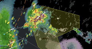
More areas/communities have been added to the air quality alerts. At 8:00 a.m. the areas outlined with blue have been added under a yellow alert. Impact Level: Moderate Forecast Confidence: High The warning has now been changed to an orange level alert. Environment Canada issued an update at 7:54 changing the impact level to High from Moderate. During heavy smoke ...
Read More »Air Quality Alerts – UPDATED July 15, 8:00