There were no new fires in the Northeast Region by late afternoon today. At the time of this update, there is one wildland fires in the region. Timmins 2 covers 4,645 hectares. The fire is now being held. Crews continue to identify hot spots along the fire’s perimeter. Ministry of Natural Resources and Forestry staff continue to work with the ...
Read More »Weather, Closures, Forest Fires
Highway 590 CLOSED – washout
Thunder Bay Detachment of the Ontario Provincial Police (OPP) is advising that Highway 590 is closed between Boreal Road and Adrian Lake Road due to a washout. An update will be provided as it becomes available.
Read More »Northeast Forest Fire Update – June 21
There were no new fires in the Northeast Region by late afternoon today. At the time of this update, there are two wildland fires in the region. Cochrane 8 is being held at 3.5 hectares. It is located northwest of Fort Severn in the Far North. Timmins 2 covers 4,645 hectares. It is “not under control”. The fire remains approximately ...
Read More »Northeast Forest Fire Update – June 20
There were no new fires in the Northeast Region by late afternoon today. At the time of this update, there are two wildland fires in the region. Cochrane 8 is a 3.5-hectare fire located northwest of Fort Severn in the Far North. Timmins 2 covers 4,645 hectares. It is “not under control”. The fire remains approximately 4 kilometres west of ...
Read More »Northeast Forest Fire Update – June 18
There were no new fires in the Northeast Region by late afternoon today. At the time of this update, there is one wildland fire in the region. Timmins 2 covers 4,645 hectares. It is “not under control”. The fire remains approximately 4 kilometres west of the community of Gogama. At the time of this update, the fire hazard is low ...
Read More »Northeast Forest Fire Update – June 17
There were no new fires in the Northeast Region by late afternoon today. At the time of this update, there is one wildland fire in the region. Timmins 2 was remapped and is now listed at 4,645 hectares, its status is “not under control”. The fire remains approximately 4 kilometres west of the community of Gogama. At the time of ...
Read More »Northeast Forest Fire Update – June 17
There were no new fires in the Northeast Region by late afternoon on June 16. At the time of this update, there is one wildland fire in the region. Timmins 2 was remapped and is now listed at 4,645 hectares, its status is “not under control”. The fire remains approximately 4 kilometres west of the community of Gogama. Ground ...
Read More »Northeast Fire Region Update – June 14
There were no new fires in the Northeast Region by late afternoon on June 14. At the time of this update, there is one wildland fire in the region. Timmins 2 remains at 5622 hectares, and its status is “not under control”. The fire remains approximately 4 kilometres west of the community of Gogama. The fire is burning on the ...
Read More »Northeast Forest Fire Update – June 12
There were no new fires in the Northeast Region by the mid-afternoon of June 12. At the time of this update, there were three active fires in the Northeast region, one of which was not under control and two fires that were under control. The fire hazard is low across the Northeast Region with the exception of a moderate hazard ...
Read More »Northeast Forest Fire Update – June 11
As of the early evening of June 11, there are three active wildland fires in the region. Chapleau 4 is located north of Hwy 101 between Timmins and Chapleau. It is being held at 16.5 hectares. Sudbury 2 is under control at 0.2 of a hectare, on the southwest side of Windy Lake. Timmins 2 was remapped at 5622 hectares on ...
Read More »Sultan Road remains Closed due to Culvert Washout
Wawa-news reported yesterday afternoon at 4:30 that reports were that the Sultan Road was impassable due to a culvert that had washed out in the rain. That was confirmed by EACOM Timber Corporation that at KM 69 the road has washed away. This morning EACOM Timber Corporation advises that their staff are on their way to assess ...
Read More »Northeast Forest Fire Update- June 11
As of the early evening of June 10, there are four active wildland fires in the region. Chapleau 4 is located north of Hwy 101 between Timmins and Chapleau. It is being held at 16.5 hectares. Sudbury 2 is under control at 0.2 of a hectare, on the southwest side of Windy Lake. Sudbury 6 is under control at 0.5 of ...
Read More »Rainfall Warning continues Southeast of Wawa
A Rainfall Warning is in effect for: • Agawa – Lake Superior Park • Montreal River Harbour – Batchawana Bay – Searchmont • Sault Ste. Marie – St. Joseph Island • Blind River – Thessalon • Chapleau – Missinaibi Lake Rain, at times heavy, continues. Heavy rainfall will continue today and into tonight. Total rainfall amounts near 50 ...
Read More »Mattagami First Nation Declares State of Emergency
Mattagami First Nation Emergency Management has declared a State of Emergency as of 5:30 p.m. Sunday Evening, June 9th, 2019 for Preventative Precautionary Measures to ensure all Community Members are safe. TIM002 Fire is approximately 2,500 hectares. Smoke is visible and power interruption is possible. People on the evacuation list at this time will be people with illness; the elderly, parents ...
Read More »TIM002 UPDATE – June 9
Timmins Forest Fire 2 (referred to as TIM002) was confirmed on June 6, 2019. This evening, June 9, 2019, the Ministry of Natural Resources and Forestry (MNRF) estimated TIM002 to be 6,000 hectares. The fire is approximately 4 kilometres west of the community of Gogama, and burning on the west side of Highway 144, running parallel to the roadway. It’s ...
Read More »
Wawa-news.com Local and Regional News
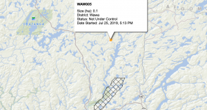