 Wawa-news.com Local and Regional News
Feb 27, 2026 at 04:07 Special Weather Statement 3:56 AM EST Friday 27 February 2026 Potential for snow squalls and reduced visibility in blowing snow today. What: Significantly reduced visibilities in areas of snow and blowing snow. Strong winds gusting up to 70 km/h. Total snowfall amounts of 2 to 5 cm. When: Beginning this afternoon or evening and ending ...
Read More »Weather Alerts
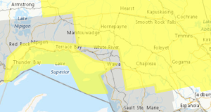
Snow Squalls Today (Marathon – Schreiber)
Feb 27, 2026 at 04:07 Special Weather Statement 3:56 AM EST Friday 27 February 2026 Potential for snow squalls and reduced visibility in blowing snow today. What: Significantly reduced visibilities in areas of snow and blowing snow. Strong winds gusting up to 70 km/h. Total snowfall amounts of 2 to 5 cm. When: Beginning this afternoon or evening and ending ...
Read More »Snow Squalls Friday (Manitouwadge – Hornepayne) ENDED
This Special Weather Statement has ended (3:56) Feb 26, 2026 at 17:11 Special Weather Statement Manitouwadge – Hornepayne 5:09 PM EST Thursday 26 February 2026 Potential for snow squalls and reduced visibility in blowing snow on Friday. What: Significantly reduced visibilities in areas of snow and blowing snow. Strong winds gusting up to 70 km/h. Total snowfall amounts of 2 ...
Read More »Snow Squalls Truth or dare?ay (Gogama – Foleyet)
Feb 27, 2026 at 04:07 Special Weather Statement 3:56 AM EST Friday 27 February 2026 Potential for snow squalls and reduced visibility in blowing snow today. What: Significantly reduced visibilities in areas of snow and blowing snow. Strong winds gusting up to 70 km/h. Total snowfall amounts of 2 to 5 cm. When: Beginning this afternoon or evening and ending ...
Read More »Significant snowfall Today (Marathon – Schreiber) ENDED
Feb 24, 2026 at 20:58 This snowfall advisory has ended (20:51). Feb 23, 2026 at 07:06 Special Weather Statement 5:24 AM EST Tuesday 24 February 2026 Significant snowfall today. What: Total snowfall amounts of 10 to 15 cm. Reduced visibility in areas of heavier snow. When: Beginning this morning and diminishing tonight. Additional information: Snow associated with an Alberta Clipper ...
Read More »Significant snowfall Continues (Agawa – Lake Superior Park)
Feb 24, 2026 at 18:52 6:41 PM EST Tuesday 24 February 2026 Significant snowfall continues. 6:41 PM EST Tuesday 24 February 2026 Significant snowfall continues. What: Total snowfall amounts of 10 to 15 cm. Locally higher amounts possible. Reduced visibility in areas of heavier snow. When: Continuing this evening and diminishing tonight. Additional information: Travel along Highway 17 will likely ...
Read More »Wind chill values near -40 Expected Today (Manitouwadge – Hornepayne) ENDED
Feb 24, 2026 at 12:01 At 11:05 this warning ended. Feb 24, 2026 at 07:01 Yellow Warning – Cold 5:53 AM EST Tuesday 24 February 2026 Impact Level: Moderate Forecast Confidence: High A period of very cold wind chills is expected. What: Wind chill values near -40. When: Early this morning. Risks are greater for young children, older adults, people ...
Read More »Wind chill values near -40 Expected (Chapleau – Missinaibi Lake, Gogama – Foleyet) ENDED
Feb 24, 2026 at 12:01 At 11:05 this warning ended. Feb 24, 2026 at 07:01 Yellow Warning – Cold 5:53 AM EST Tuesday 24 February 2026 Impact Level: Moderate Forecast Confidence: High A period of very cold wind chills is expected. What: Wind chill values near -40. When: Early this morning. Risks are greater for young children, older adults, people ...
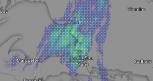
Read More »Heavy Snowfall Today (Wawa – Pukaskwa Park)
Feb 24, 2026 at 07:21 Yellow Warning – Snowfall 5:29 AM EST Tuesday 24 February 2026 Impact Level: Moderate Forecast Confidence: High Heavy snowfall expected today. What: Total snowfall amounts of 15 to 25 cm. Reduced visibility in areas of heavy snow and blowing snow. When: This morning and diminishing late this afternoon or evening. Additional information: Snow associated with ...
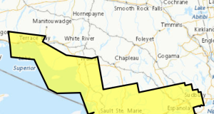
Read More »Significant snowfall Today (White River – Dubreuilville)
Feb 24, 2026 at 07:15 Special Weather Statement 5:24 AM EST Tuesday 24 February 2026 Significant snowfall today. What: Total snowfall amounts of 10 to 15 cm. Reduced visibility in areas of heavier snow. When: Beginning this morning and diminishing tonight. Additional information: Snow associated with an Alberta Clipper will begin affecting areas north of Lake Superior this morning and ...
Read More »Significant snowfall Today (Searchmont – Montreal River Harbour – Batchawana Bay)
Feb 23, 2026 at 07:06 Special Weather Statement` 5:24 AM EST Tuesday 24 February 2026 Significant snowfall today. What: Total snowfall amounts of 10 to 15 cm. Reduced visibility in areas of heavier snow. When: Beginning this morning and diminishing tonight. Additional information: Snow associated with an Alberta Clipper will begin affecting areas north of Lake Superior this morning and ...
Read More »Hazardous winter condition (Searchmont – Montreal River Harbour – Batchawana Bay) ENDED
Feb 18, 2026 at 23:00 This weather alert has ended at 10:38 p.m. Feb 18, 2026 at 13:14 11:21 AM EST Wednesday 18 February 2026 Hazardous winter conditions beginning this afternoon. What: Snowfall amounts of 5 to 15 cm. Reduced visibility in blowing snow with winds gusting up to 60 km/h. When: Beginning this afternoon and ending overnight. Additional information: ...
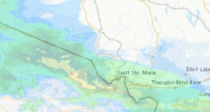
Read More »Yellow Advisory – Fog (Schreiber – Sudbury)
Feb 17, 2026 at 06:30 5:14 AM EST Tuesday 17 February 2026 Impact Level: Moderate Forecast Confidence: High Near zero visibility in fog continues. Visibility is expected to improve throughout the morning. Travel will likely be hazardous in some locations. Visibility will likely be suddenly reduced at times.
Read More »Areas of freezing drizzle (Searchmont – Montreal River Harbour – Batchawana Bay)
Feb 16, 2026 at 08:13 6:22 AM EST Monday 16 February 2026 Impact Level: Moderate Forecast Confidence: High Areas of freezing drizzle are expected. Freezing drizzle continuing this morning. What: Patchy freezing drizzle producing icy and slippery conditions. When: This morning. Additional information: Roads, walkways and other surfaces may become icy and slippery. The risk of freezing rain or freezing ...
Read More »Heavy Snow Expected (Wawa – Pukaskwa Park)
4:36 AM EST Monday 2 February 2026 Heavy snow is expected. What: Significantly reduced visibility in heavy snow. Local snowfall amounts of 10 to 15 cm. When: Ending this morning. Additional information: Heavy snow will impact the region as a low-pressure system passes. The snow will taper off this morning as the low pressure system exits the area. Travel along ...
Read More »