 Wawa-news.com Local and Regional News
Dec 19, 2025 at 13:06 The highway has been reopened. Please drive with care. Dec 19, 2025 at 05:22 Highway 17 remains closerd between Wawa and Batchawana due to weather. Dec 18, 2025 at 22:13 Highway 17 has been closed from Wawa to Batchawana due to poor weather and road conditions.
Read More »Weather Alerts
Hwy 101 (Wawa to Chapleau) OPEN
Dec 19, 2025 at 12:50 Highway 101 has been opened. Please drive with care. Dec 18, 2025 at 21:01 Highway 101 has been closed from Wawa to Chapleau due to poor weather and road conditions.
Read More »OPP Remind motorists to obey Road Closures

With winter weather continuing to impact the North East Region, the Ontario Provincial Police (OPP) is reminding motorists that road closures due to hazardous weather conditions are implemented for public safety and must be obeyed. During severe winter weather, OPP officers and partner agencies may temporarily close roads and highways when conditions deteriorate and pose a significant risk to motorists, ...
Read More »School Bus Cancellations
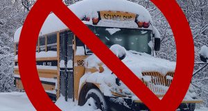
Dec 19, 2025 at 06:47 Northern Area Due to the inclement weather, poor road conditions, and in the interest of safety, all school-related transportation servicing schools in Wawa, White River, Chapleau & Hornepayne will be cancelled for today. Schools will remain open. Sault Ste Marie Area – including Batchawana, Goulais River, Searchmont & area Due to the flash freezing concerns, icy road conditions, ...
Read More »Hwy 614 (Jct 17/614 to Manitouwadge) OPEN
Dec 19, 2025 at 06:21 Highway 614 has been reopened. Dec 18, 2025 at 21:41 Poor weather and road conditions have closed Hwy 614 (Jct 17/614 to Manitouwadge). Dec 18, 2025 at 11:52 The highway has been reopened. Dec 18, 2025 at 00:58 Poor weather conditions on Hwy 614 have closed it from the Jct 17/614 to Manitouwadge. North West ...
Read More »OPP Warn of Poor Weather Conditions to continue Today
Dec 19, 2025 at 06:09 The Ontario Provincial Police (OPP) is advising the public of poor weather conditions expected to continue both the North East Region and North West Region of Ontario today. Several communities may experience heavy rainfall, snowfall, whiteout conditions on open stretches of highway, and periods of freezing rain, resulting in slippery and icy road surfaces as ...
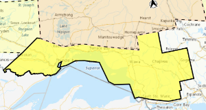
Read More »Special Weather Statement (Agawa – Lake Superior Park)
Dec 18, 2025 at 13:36 11:26 AM EST Thursday 18 December 2025 Rain today, followed by a possible flash freeze tonight into Friday. Total rainfall amounts of 10 to 20 mm. Flash freeze. Local snowfall amounts of 5 to 10 cm from Montreal River to Earlton and north. Reduced visibility in snow and blowing snow for some areas. When: This ...
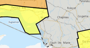
Read More »Winter Storm Warning (Wawa – Pukaskwa Park)
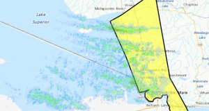
Yellow Warning – Winter Storm 2:31 PM EST Thursday 18 December 2025 Impact Level: Moderate Forecast Confidence: High Winter storm expected through Friday morning. What: Total snowfall amounts are expected to range from 10 cm near the shore of Lake Superior, including Wawa, to 15 to 20 cm for areas inland and over the higher terrain. Reduced visibility in heavy ...
Read More »Bus Cancellations: Hornepayne
Dec 18, 2025 at 06:41 Due to the inclement weather, visibility concerns, and in the interest of safety, all school-related transportation servicing schools in Hornepayne will be cancelled for today. Schools will remain open. Note: transportation is running as per normal schedule for schools in Wawa, White River & Chapleau.
Read More »Flash Freeze Warning
Dec 16, 2025 at 23:09 10:09 PM EST Tuesday 16 December 2025 Impact Level: Moderate Forecast Confidence: High Temperatures are forecast to fall rapidly. Ponding water, slush, and any falling precipitation will freeze as the temperature drops. What: Temperatures rapidly falling below freezing leading to icy conditions. When: Tonight. Additional information: A sharp cold front will push through the area ...
Read More »Hwy 17 (Wawa to Batchawana) is OPEN
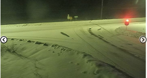
Highway 17 from Wawa to Batchawana is indeed open. It has been open since Sunday morning at 2:25. Since then, however, the mapping and text show that the highway is still closed. The screen shot to the right was taken at 10:00 a.m. ON511 does acknowledge that they are having issues with their website, via a banner on the ...
Read More »Hwy 17 (Wawa to Batchawana) OPEN
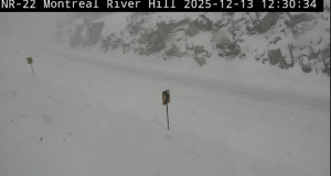
Dec 13, 2025 at 12:30 The barricade at Pinewood Drive and Hwy 17 (Wawa) has now been removed by Ledcorp and is on the shoulder of Mills Drive. Drive with care, there is still snow squall activity showing on EC mapping, and the Montreal River Hill camera shows poor roads and visibility. Dec 13, 2025 at 12:19 ON511 is no ...
Read More »Snow Squall Warning
Dec 13, 2025 at 07:16 Dec 13, 2025 at 07:16 Yellow Warning – Snow Squall 5:32 AM EST Saturday 13 December 2025 Impact Level: Moderate Forecast Confidence: High Lake effect snow squalls continuing into this afternoon. What: Total snowfall amounts of 15 to 30 cm. Significantly reduced visibility in heavy snow. When: Continuing into this afternoon. Additional information: Lake effect ...
Read More »Snow Squall Watch
5:14 AM EST Friday 12 December 2025 Affecting: Agawa – Lake Superior Park Searchmont – Montreal River – Batchawana Sault Ste. Marie – St. Joseph Island Impact Level: Moderate Forecast Confidence: High Lake effect snow likely tonight into Saturday. What: Local snowfall totals of 15 to 30 cm. Poor visibility in areas of heavy snow and blowing snow. When: Beginning ...
Read More »Significant Snowfall Likely
5:18 AM EST Friday 12 December 2025 Affecting: Marathon – Schreiber Wawa – Pukaskwa White River – Dubreuilville Significant snowfall likely today into tonight. What: Snowfall amounts of 10 to 15 cm. Low visibility in areas of heavy snow. When: This afternoon into tonight. Additional information: A weather system will bring snow to a large portion of northern Ontario. Embedded ...
Read More »