Jan 9, 2026 at 06:49 4:42 AM EST Friday 9 January 2026 Snow continue today. What: Total snowfall amounts of 10 to 15 cm. Reduced visibility in heavy snow. When: Ending this afternoon. Additional information: Temperatures will fall to below the freezing mark this morning. Any water on roadways and walkways will freeze, creating icy and slippery conditions. Jan 8, ...
Read More »Author Archives: Environment Canada
Yellow Warning – Rainfall (Montreal River – Searchmont)
Jan 8, 2026 at 09:50 Yellow Warning – Rainfall 9:06 AM EST Thursday 8 January 2026 Impact Level: Moderate Forecast Confidence: High Significant rainfall expected tonight through Friday. The frozen ground has reduced the ability to absorb this rainfall. What: Total rainfall amounts of 20 to 40 mm. When: Tonight through Friday. Additional information: A low pressure system is expected ...
Read More »Snowfall Warning for Tonight (Montreal River – St. Joseph Island) ENDED
Jan 5, 2026 at 09:22 At 8:41 this weather alert was ended. Jan 4, 2026 at 23:23 11:22 PM EST Sunday 4 January 2026 Snowfall tonight. What: Snowfall amounts of 8 to 12 cm. Reduced visibility at times in heavy snow. When: Beginning tonight and tapering off Monday morning. Additional information: Snow will taper to light flurries or freezing drizzle ...
Read More »Hazardous Winter Storm (Chapleau – Missinaibi Lake) ENDED
Dec 29, 2025 at 19:56 The storm warning eded at 18:19 Dec 29, 2025 at 16:54 Orange Warning – Winter Storm 4:14 PM EST Monday 29 December 2025 Impact Level: High Forecast Confidence: High Hazardous winter storm expected to continue tonight. What: Snowfall amounts of 40 to 60 cm. Northwesterly wind gusts of 60 to 80 km/h. Blizzard conditions. When: ...
Read More »Hazardous Winter Storm Warning (Montreal River Harbour – Searchmont) ENDED
Dec 29, 2025 at 16:46 This warning ended at 16:20. Dec 29, 2025 at 05:21 Orange Warning – Winter Storm 5:02 AM EST Monday 29 December 2025 Impact Level: High Forecast Confidence: High Hazardous winter storm continues today. What: Freezing rain with 5 to 10 mm of ice accretion. Snowfall amounts of 20 to 40 cm. Northwesterly wind gusts of ...
Read More »Hazardous Winter Storm (Agawa – Lake Superior Park) ENDED
Dec 29, 2025 at 16:32 This warning ended at 16:14. Dec 29, 2025 at 05:18 Orange Warning – Winter Storm 5:06 AM EST Monday 29 December 2025 Impact Level: High Forecast Confidence: High Hazardous winter storm expected today into tonight. What: Snowfall amounts of 40 to 60 cm. Northwesterly wind gusts of 60 to 80 km/h. Blizzard conditions. When: Today ...
Read More »Hazardous winter storm warning (Wawa – Pukaskwa Park) ENDED
Dec 29, 2025 at 14:17 This warning ended at 13:04 Dec 29, 2025 at 05:12 Yellow Warning – Winter Storm 5:08 AM EST Monday 29 December 2025 Impact Level: Moderate Forecast Confidence: High Hazardous winter storm continues into this afternoon. What: Snowfall amounts of 20 to 40 cm. Strong northwesterly winds with gusts of 60 to 80 km/h Blizzard conditions. ...
Read More »Significant Snowfall continues
Dec 25, 2025 at 08:06 7:49 AM EST Friday 26 December 2025 Impact Level: Moderate Forecast Confidence: High Significant snowfall continues. What: Total snowfall amounts of 15 to 20 cm, with locally higher amounts possible near Lake Superior. Reduced visibility in heavy snow and local blowing snow. When: Ending later this morning. Additional information: Areas near Lake Superior will ...
Read More »Winter Storm Warning (Wawa – Pukaskwa Park)
Yellow Warning – Winter Storm 2:31 PM EST Thursday 18 December 2025 Impact Level: Moderate Forecast Confidence: High Winter storm expected through Friday morning. What: Total snowfall amounts are expected to range from 10 cm near the shore of Lake Superior, including Wawa, to 15 to 20 cm for areas inland and over the higher terrain. Reduced visibility in heavy ...
Read More »Special Weather Statement (Agawa – Lake Superior Park)
Dec 18, 2025 at 13:36 11:26 AM EST Thursday 18 December 2025 Rain today, followed by a possible flash freeze tonight into Friday. Total rainfall amounts of 10 to 20 mm. Flash freeze. Local snowfall amounts of 5 to 10 cm from Montreal River to Earlton and north. Reduced visibility in snow and blowing snow for some areas. When: This ...
Read More »Snow Squall Warning
Dec 13, 2025 at 07:16 Dec 13, 2025 at 07:16 Yellow Warning – Snow Squall 5:32 AM EST Saturday 13 December 2025 Impact Level: Moderate Forecast Confidence: High Lake effect snow squalls continuing into this afternoon. What: Total snowfall amounts of 15 to 30 cm. Significantly reduced visibility in heavy snow. When: Continuing into this afternoon. Additional information: Lake effect ...
Read More »Significant Snowfall Likely
5:18 AM EST Friday 12 December 2025 Affecting: Marathon – Schreiber Wawa – Pukaskwa White River – Dubreuilville Significant snowfall likely today into tonight. What: Snowfall amounts of 10 to 15 cm. Low visibility in areas of heavy snow. When: This afternoon into tonight. Additional information: A weather system will bring snow to a large portion of northern Ontario. Embedded ...
Read More »Snow Squall Watch
Dec 3, 2025 at 05:41 Yellow Watch – Snow Squall Agawa – Lake Superior Park Chapleau – Missinaibi Lake Gogama – Foleyet Kapuskasing – Hearst – Smooth Rock Falls Kirkland Lake – Englehart Little Abitibi – Kesagami Lake Searchmont – Montreal River Harbour – Batchawana Bay Temiskaming Shores – Temagami Timmins – Cochrane – Iroquois Falls Wawa – Pukaskwa Park ...
Read More »Snow Squall Warning (Agawa – Lake Superior Park)
Dec 2, 2025 at 06:14 5:40 AM EST Tuesday 2 December 2025 Impact Level: Moderate Forecast Confidence: High Snow squalls continue this morning. Additional local amounts of 5 to 10 cm Continuing into this morning or early afternoon. Snow squalls are expected to weaken through the morning and early afternoon. Roads and walkways will likely be difficult to navigate due ...
Read More »Snow Squall Warning (Wawa – Pukaskwa Park)
Dec 2, 2025 at 06:14 5:40 AM EST Tuesday 2 December 2025 Impact Level: Moderate Forecast Confidence: High Snow squalls continue this morning. Additional local amounts of 5 to 10 cm Continuing into this morning or early afternoon. Snow squalls are expected to weaken through the morning and early afternoon. Roads and walkways will likely be difficult to navigate due ...
Read More »
Wawa-news.com Local and Regional News
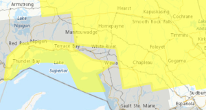
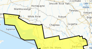
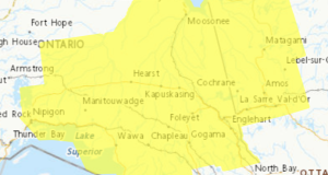
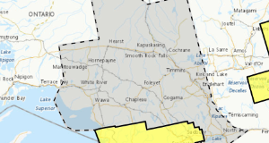