 Wawa-news.com Local and Regional News
Yellow Advisory – Freezing Drizzle 4:02 PM EST Wednesday 4 March 2026 Impact Level: Moderate Forecast Confidence: High Areas of freezing drizzle are expected. Freezing drizzle is expected to continue this afternoon and evening. Roads, walkways, and other surfaces will likely become icy and slippery. Be very careful if walking or driving.
Read More »Weather, Closures, Forest Fires
Freezing Drizzle Expected (Gogama – Foleyet)
Yellow Advisory – Freezing Drizzle 4:02 PM EST Wednesday 4 March 2026 Impact Level: Moderate Forecast Confidence: High Areas of freezing drizzle are expected. Freezing drizzle is expected to continue this afternoon and evening. Roads, walkways, and other surfaces will likely become icy and slippery. Be very careful if walking or driving. Mar 4, 2026 at 14:54 Yellow Advisory – ...
Read More »Freezing Drizzle Expected (Marathon – Schreiber)
Mar 4, 2026 at 16:22 Yellow Advisory – Freezing Drizzle 4:02 PM EST Wednesday 4 March 2026 Impact Level: Moderate Forecast Confidence: High Areas of freezing drizzle are expected. Freezing drizzle is expected to continue this afternoon and evening. Roads, walkways, and other surfaces will likely become icy and slippery. Be very careful if walking or driving. Mar 4, 2026 ...
Read More »Freezing Drizzle Expected (Wawa – Pukaskwa Park)
Mar 4, 2026 at 16:22 Yellow Advisory – Freezing Drizzle 4:02 PM EST Wednesday 4 March 2026 Impact Level: Moderate Forecast Confidence: High Areas of freezing drizzle are expected. Freezing drizzle is expected to continue this afternoon and evening. Roads, walkways, and other surfaces will likely become icy and slippery. Be very careful if walking or driving. Mar 4, 2026 ...
Read More »Freezing Drizzle Expected (Manitouwadge – Hornepayne)
Mar 4, 2026 at 14:54 Yellow Advisory – Freezing Drizzle 2:49 PM EST Wednesday 4 March 2026 Impact Level: Moderate Forecast Confidence: High Areas of freezing drizzle are expected. Freezing drizzle is expected to continue this afternoon and evening. Roads, walkways, and other surfaces will likely become icy and slippery. Be very careful if walking or driving.
Read More »Hwy 17 (Wawa to Heyden) OPEN

The highway has been reopened. Feb 28, 2026 at 02:05 Hwy 17 is closed from Wawa to Heyden due to poor weather conditions.
Read More »Hwy 17 (Marathon – Nipigon) OPEN
Feb 28, 2026 at 00:42 The highway is open. Feb 27, 2026 at 22:17 Hwy 17 from Marathon to Nipigon is closed due to poor weather conditions
Read More »Snow Squalls Today (Chapleau – Missinaibi Lake)
Feb 27, 2026 at 04:07 Special Weather Statement 3:56 AM EST Friday 27 February 2026 Potential for snow squalls and reduced visibility in blowing snow today. What: Significantly reduced visibilities in areas of snow and blowing snow. Strong winds gusting up to 70 km/h. Total snowfall amounts of 2 to 5 cm. When: Beginning this afternoon or evening and ending ...
Read More »Snow Squalls Today (Agawa – Lake Superior Park)
Feb 27, 2026 at 04:07 Special Weather Statement 3:56 AM EST Friday 27 February 2026 Potential for snow squalls and reduced visibility in blowing snow today. What: Significantly reduced visibilities in areas of snow and blowing snow. Strong winds gusting up to 70 km/h. Total snowfall amounts of 2 to 5 cm. When: Beginning this afternoon or evening and ending ...
Read More »Snow Squalls Today (Wawa – Pukaskwa Park)
Feb 27, 2026 at 04:07 Special Weather Statement 3:56 AM EST Friday 27 February 2026 Potential for snow squalls and reduced visibility in blowing snow today. What: Significantly reduced visibilities in areas of snow and blowing snow. Strong winds gusting up to 70 km/h. Total snowfall amounts of 2 to 5 cm. When: Beginning this afternoon or evening and ending ...
Read More »Snow Squalls Today (White River – Dubreuilville)
Feb 27, 2026 at 04:07 Special Weather Statement 3:56 AM EST Friday 27 February 2026 Potential for snow squalls and reduced visibility in blowing snow today. What: Significantly reduced visibilities in areas of snow and blowing snow. Strong winds gusting up to 70 km/h. Total snowfall amounts of 2 to 5 cm. When: Beginning this afternoon or evening and ending ...
Read More »Snow Squalls Today (Marathon – Schreiber)
Feb 27, 2026 at 04:07 Special Weather Statement 3:56 AM EST Friday 27 February 2026 Potential for snow squalls and reduced visibility in blowing snow today. What: Significantly reduced visibilities in areas of snow and blowing snow. Strong winds gusting up to 70 km/h. Total snowfall amounts of 2 to 5 cm. When: Beginning this afternoon or evening and ending ...
Read More »Snow Squalls Friday (Manitouwadge – Hornepayne) ENDED
This Special Weather Statement has ended (3:56) Feb 26, 2026 at 17:11 Special Weather Statement Manitouwadge – Hornepayne 5:09 PM EST Thursday 26 February 2026 Potential for snow squalls and reduced visibility in blowing snow on Friday. What: Significantly reduced visibilities in areas of snow and blowing snow. Strong winds gusting up to 70 km/h. Total snowfall amounts of 2 ...
Read More »Snow Squalls Truth or dare?ay (Gogama – Foleyet)
Feb 27, 2026 at 04:07 Special Weather Statement 3:56 AM EST Friday 27 February 2026 Potential for snow squalls and reduced visibility in blowing snow today. What: Significantly reduced visibilities in areas of snow and blowing snow. Strong winds gusting up to 70 km/h. Total snowfall amounts of 2 to 5 cm. When: Beginning this afternoon or evening and ending ...
Read More »Mess on Montreal River Hill – Hwy 17 (Wawa to Batchawana) OPEN
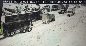
Feb 25, 2026 at 08:53 The highway has been reopened. Feb 25, 2026 at 05:31 Although there are no longer any vehicles stuck on the Montreal River Hill, weather and road conditions have kept the highway closeed. Feb 24, 2026 at 17:55 It appears that this CMV is stuck going up the Montreal River Hill. It is visible at 17:45 ...
Read More »