 Wawa-news.com Local and Regional News
Apr 7, 2026 at 02:25 The highway has been reopened (1:45 a.m.). Apr 6, 2026 at 23:48 The highway closure has been changed. The highway is now closed from Wawa to Batchawana/Hwy 563 (23:39). The transports are stuck trying to ascend on the Alona Bay Hill heading northbound. Apr 6, 2026 at 23:14 The MTO (Ledcor) just dropped the highway ...
Read More »Weather, Closures, Forest Fires
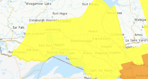
Flood Watch – Chapleau Wawa District
The Ministry of Natural Resources – Chapleau Wawa District is advising area residents that a Flood Watch is in effect in the District until Wednesday, April 08, 2026 at 4:00pm. Residents in the Chapleau Wawa District area should keep a close watch on conditions and exercise caution around lakes, rivers, creeks and streams. Roads and walkways will likely be difficult ...
Read More »Winter Storm Today (Chapleau – Missinaibi Lake)
Apr 4, 2026 at 07:13 Yellow Warning – Winter Storm 5:22 AM EDT Saturday 4 April 2026 Impact Level: Moderate Forecast Confidence: High Hazardous winter conditions expected today. What: Total snowfall and ice pellet amounts of 10 to 15 cm. Peak snowfall rates of 2 to 4 cm per hour. Reduced visibility in heavy snow and local blowing snow. Freezing ...
Read More »Winter Storm Today (Agawa – Lake Superior Park)
Apr 4, 2026 at 07:13 Yellow Warning – Winter Storm 5:22 AM EDT Saturday 4 April 2026 Impact Level: Moderate Forecast Confidence: High Hazardous winter conditions expected today. What: Total snowfall and ice pellet amounts of 10 to 15 cm. Peak snowfall rates of 2 to 4 cm per hour. Reduced visibility in heavy snow and local blowing snow. Freezing ...
Read More »Snowfall Today (Wawa – Pukaskwa Park)
Apr 4, 2026 at 07:13 Yellow Warning – Winter Storm 5:22 AM EDT Saturday 4 April 2026 Impact Level: Moderate Forecast Confidence: High Snowfall with total amounts of 10 to 20 cm is expected. What: Total snowfall amounts of 10 to 20 cm. Peak snowfall rates of 2 to 4 cm per hour. Reduced visibility in heavy snow and local ...
Read More »Snowfall Today (White River – Dubreuilville)
Apr 4, 2026 at 07:13 Yellow Warning – Winter Storm 5:30 AM EDT Saturday 4 April 2026 Impact Level: Moderate Forecast Confidence: High Snowfall with total amounts of 10 to 20 cm is expected. What: Total snowfall amounts of 10 to 20 cm. Peak snowfall rates of 2 to 4 cm per hour. Reduced visibility in heavy snow and local ...
Read More »Snowfall Today (Manitouwadge – Hornepayne)
Apr 4, 2026 at 07:13 Yellow Warning – Winter Storm 5:30 AM EDT Saturday 4 April 2026 Impact Level: Moderate Forecast Confidence: High Snowfall with total amounts of 10 to 20 cm is expected. What: Total snowfall amounts of 10 to 20 cm. Peak snowfall rates of 2 to 4 cm per hour. Reduced visibility in heavy snow and local ...
Read More »Snowfall Today (Marathon – Schreiber)
Apr 4, 2026 at 07:13 Yellow Warning – Winter Storm 5:15 AM EDT Saturday 4 April 2026 Impact Level: Moderate Forecast Confidence: High Snowfall with total amounts of 15 to 30 cm is expected. What: Total snowfall amounts of 15 to 30 cm. Peak snowfall rates of 2 to 4 cm per hour. Reduced visibility in heavy snow and local ...
Read More »Hwy 17 (Wawa – Batchawana) OPEN
Apr 3, 2026 at 15:07 Highway 17 was reopened at 14:48. Apr 3, 2026 at 10:33 On511 is showing that Hwy 17 is closed from Wawa to Batchawana. The section from Batchawana to Heyden is now open. Apr 3, 2026 at 06:30 The highway remains closed at this time. Apr 2, 2026 at 19:35 If you happen to be caught ...
Read More »Hwy 101 (Wawa – Chapleau & Foleyet – Jct 144/101) OPEN 14:24
Apr 3, 2026 at 14:24 Hwy 101 is completely open. Apr 3, 2026 at 10:30 Hwy 101 has been opened between Chapleau and Foleyet. Hwy 101 remains closed from Wawa to Chapleau and Foleyet to Jct 144/101 (Timmins). Apr 3, 2026 at 06:30 The highway remains closed at this time. Apr 2, 2026 at 18:40 ON511 is reporting that weather ...
Read More »Hwy 129 (Chapleau to Hwy 667 Sultan) OPEN 14:24
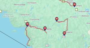
Apr 3, 2026 at 14:24 Hwy 129 is completely open. Apr 3, 2026 at 10:45 ON511 is showing that Hwy 129 is still closed from Chapleau to the Jct of 101/667 Sultan) and open from 667 south to Wharncliffe/Hwy 554. Apr 3, 2026 at 06:30 The highway remains closed at this time. Apr 2, 2026 at 19:29 ON511 is reporting ...
Read More »Hwy 144 (Watershed Jct 144/560 – Jct 144/101) OPEN
Apr 3, 2026 at 14:24 Hwy 101 is completely open. Apr 3, 2026 at 06:30 The highway remains closed at this time. Apr 2, 2026 at 21:41 ON511 is reporting that weather conditions on Hwy 144 have closed Hwy 144 from the Arctic Watershed Marker (just north of the Jct 144/560 to the Junction of Jct 144/101 (Timmins). The highway ...
Read More »Hwy 631 (Hornepayne to Hwy 11) OPEN 10:44
Apr 3, 2026 at 10:44 Hwy 631 has been opened from Hornepayne to Hwy 11. Apr 3, 2026 at 06:10 ON511 is reporting that weather conditions on Hwy 631 have closed Hwy 631 between Hornepayne and the Junction of Hwy 631 at Hwy 11. The highway was closed at 5:06 a.m.
Read More »Northeast Forest Fire Region Update – April 1
April 1st, marks the beginning of fire season. Ontario’s outdoor fire rules are now in effect. At this time, updates about the fire situation will be published twice weekly. Please note: The next update will be provided on Tuesday, April 7. Northeast Region There are currently no active wildland fires in the Northwest Region. Wildland Fire Management Act Effective today, several ...
Read More »School Buses (Sault Ste Marie Area, Central Algoma Area Shore Area, North Shore Area) – Cancelled
Due to the forecasted freezing rain and in the interest of safety, all school-related transportation will be cancelled today for the areas below: Sault Ste Marie Area – including Batchawana, Goulais River, Searchmont & area Central Algoma Area – including Echo Bay, Bruce Mines, Desbarats, St. Joe Island, Thessalon North Shore Area – including Iron Bridge, Blind River, Elliot Lake, Spanish & area. All schools ...
Read More »