 Wawa-news.com Local and Regional News
Updated: September 25, 2026 at 5:38 p.m. Central Daylight Time (CDT). One new fire was confirmed in the Northwest Region by the early evening of Sept. 25. Sioux Lookout 117 (SLK 117) was located near the western shore of Chicago Bay on Little Vermilion Lake in Ojibway Provincial Park – approximately 20 kilometres southwest of Sioux Lookout. The 0.1 hectare fire has been called out. At ...
Read More »Weather, Closures, Forest Fires
NE Forest Fire Region Update – September 24
Updated: September 24, 2026 at 6:00 p.m. Eastern Daylight Time (EDT) No new wildland fires were confirmed in the Northeast Region today. There are currently no active wildland fires in the Northeast Region.
Read More »NW Forest Fire Region Update – September 24
Updated: September 24, 2026 at 5:16 p.m. Central Daylight Time (CDT). No new fires were confirmed in the Northwest Region by the early evening hours of Sept. 24. At the time of this update there are 27 active fires in the Northwest Region. Among these fires, 9 are under control and 18 fires are being observed.
Read More »NE Forest Fire Region Update – September 23
Updated: September 23, 2026 at 6:00 p.m. Eastern Daylight Time (EDT) One wildland fire was confirmed after the update last night: Sudbury 62 (SUD062) is 0.5 hectares in size and located on the northern shore of Clear Lake, northwest of the community of Spanish. This fire is under control. No new wildland fires were confirmed in the Northeast Region today. There is ...
Read More »NW Forest Fire Region Update – September 23
Updated: September 23, 2026 at 5:28 p.m. Central Daylight Time (CDT). No new fires were confirmed in the Northwest Region by the early evening hours of Sept. 23. At the time of this update there are 27 active fires in the Northwest Region. Among these fires, 9 are under control and 18 fires are being observed.
Read More »NW Forest Fire Region Update – September 22
Updated: September 22,2026 at 5:51 p.m. Central Daylight Time (CDT). One new fire was confirmed in the Northwest Region by the early evening hours of Sept. 22. Thunder Bay 89 (THU089) is located in Pigeon River Provincial Park, approximately 42 kilometres south of Thunder Bay. The fire is not under control at 0.1 hectares in size. At the time of this update there are 30 active fires ...
Read More »NE Forest Fire Region Update – September 22
Updated: September 22, 2026 at 6:00 p.m. Eastern Daylight Time (EDT) No new wildland fires were confirmed in the Northeast Region today. There are currently no active wildland fires in the Northeast Region.
Read More »NW Forest Fire Region Update – September 21
Updated: September 21, 2026 at 5:20 p.m. Central Daylight Time (CDT). There was no new wildland fires confirmed in the Northwest Region by the evening of September 21. At the time of this update there are 29 active wildland fires in the Northwest Region. Of those fires, 9 are under control and 20 are being observed.
Read More »NE Forest Fire Region Update – September 21
Updated: September 21, 2026 at 6:00 p.m. Eastern Daylight Time (EDT) No new wildland fires were confirmed in the Northeast Region today. There are currently 6 active wildland fires in the Northeast Region. All of these fires are being observed.
Read More »NE Forest Fire Region Update – September 20
Updated: September 20, 2026 at 6:00 p.m. Eastern Daylight Time (EDT) No new wildland fires were confirmed in the Northeast Region today. There are currently 6 active wildland fires in the Northeast Region. All of these fires are being observed.
Read More »NW Forest Fire Region Update – September 20
Updated: September 20, 2026 at 5:30 p.m. Central Daylight Time (CDT). There was no new wildland fires confirmed in the Northwest Region by the evening of September 20. At the time of this update there are 31 active wildland fires in the Northwest Region. Of those fires, 9 are under control and 22 are being observed.
Read More »NE Forest Fire Region Update – September 18
Updated: September 18, 2026 at 6:00 p.m. Eastern Daylight Time (EDT) No new wildland fires were confirmed in the Northeast Region today. There are currently 6 active wildland fires in the Northeast Region. All of these fires are being observed.
Read More »NW Forest Fire Region Update – September 18
Updated: September 18, 2026 at 6:00 p.m. Central Daylight Time (CDT). No new wildland fires were confirmed in the Northwest Region by the evening of September 18. At the time of this update there are 31 active wildland fires in the Northwest Region. Of those fires, 9 are under control and 22 are being observed.
Read More »Yellow Frost Warning (Wawa – Pukaskwa Park & area)
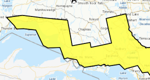
Sep 19, 2026 at 07:46 Yellow Advisory – Frost 6:20 AM EDT Saturday 19 September 2026 Impact Level: Moderate Forecast Confidence: High Agawa – Lake Superior Park Blind River – Thessalon Elliot Lake – Ranger Lake Marathon – Schreiber Nipigon – Rossport Searchmont – Montreal River Harbour – Batchawana Bay Wawa – Pukaskwa Park White River – Dubreuilville Patchy frost ...
Read More »NE Forest Fire Region Update – September 17
Updated: September 17, 2026 at 6:00 p.m. Eastern Daylight Time (EDT) No new wildland fires were confirmed in the Northeast Region today. There are currently 6 active wildland fires in the Northeast Region. All of these fires are being observed.
Read More »