Feb 24, 2026 at 20:58 This snowfall advisory has ended (20:51). Feb 23, 2026 at 07:06 Special Weather Statement 5:24 AM EST Tuesday 24 February 2026 Significant snowfall today. What: Total snowfall amounts of 10 to 15 cm. Reduced visibility in areas of heavier snow. When: Beginning this morning and diminishing tonight. Additional information: Snow associated with an Alberta Clipper ...
Read More »Author Archives: Environment Canada
Significant snowfall Continues (Agawa – Lake Superior Park)
Feb 24, 2026 at 18:52 6:41 PM EST Tuesday 24 February 2026 Significant snowfall continues. 6:41 PM EST Tuesday 24 February 2026 Significant snowfall continues. What: Total snowfall amounts of 10 to 15 cm. Locally higher amounts possible. Reduced visibility in areas of heavier snow. When: Continuing this evening and diminishing tonight. Additional information: Travel along Highway 17 will likely ...
Read More »Wind chill values near -40 Expected Today (Manitouwadge – Hornepayne) ENDED
Feb 24, 2026 at 12:01 At 11:05 this warning ended. Feb 24, 2026 at 07:01 Yellow Warning – Cold 5:53 AM EST Tuesday 24 February 2026 Impact Level: Moderate Forecast Confidence: High A period of very cold wind chills is expected. What: Wind chill values near -40. When: Early this morning. Risks are greater for young children, older adults, people ...
Read More »Wind chill values near -40 Expected (Chapleau – Missinaibi Lake, Gogama – Foleyet) ENDED
Feb 24, 2026 at 12:01 At 11:05 this warning ended. Feb 24, 2026 at 07:01 Yellow Warning – Cold 5:53 AM EST Tuesday 24 February 2026 Impact Level: Moderate Forecast Confidence: High A period of very cold wind chills is expected. What: Wind chill values near -40. When: Early this morning. Risks are greater for young children, older adults, people ...
Read More »Heavy Snowfall Today (Wawa – Pukaskwa Park)
Feb 24, 2026 at 07:21 Yellow Warning – Snowfall 5:29 AM EST Tuesday 24 February 2026 Impact Level: Moderate Forecast Confidence: High Heavy snowfall expected today. What: Total snowfall amounts of 15 to 25 cm. Reduced visibility in areas of heavy snow and blowing snow. When: This morning and diminishing late this afternoon or evening. Additional information: Snow associated with ...
Read More »Significant snowfall Today (White River – Dubreuilville)
Feb 24, 2026 at 07:15 Special Weather Statement 5:24 AM EST Tuesday 24 February 2026 Significant snowfall today. What: Total snowfall amounts of 10 to 15 cm. Reduced visibility in areas of heavier snow. When: Beginning this morning and diminishing tonight. Additional information: Snow associated with an Alberta Clipper will begin affecting areas north of Lake Superior this morning and ...
Read More »Significant snowfall Today (Searchmont – Montreal River Harbour – Batchawana Bay)
Feb 23, 2026 at 07:06 Special Weather Statement` 5:24 AM EST Tuesday 24 February 2026 Significant snowfall today. What: Total snowfall amounts of 10 to 15 cm. Reduced visibility in areas of heavier snow. When: Beginning this morning and diminishing tonight. Additional information: Snow associated with an Alberta Clipper will begin affecting areas north of Lake Superior this morning and ...
Read More »Hazardous winter condition (Searchmont – Montreal River Harbour – Batchawana Bay) ENDED
Feb 18, 2026 at 23:00 This weather alert has ended at 10:38 p.m. Feb 18, 2026 at 13:14 11:21 AM EST Wednesday 18 February 2026 Hazardous winter conditions beginning this afternoon. What: Snowfall amounts of 5 to 15 cm. Reduced visibility in blowing snow with winds gusting up to 60 km/h. When: Beginning this afternoon and ending overnight. Additional information: ...
Read More »Yellow Advisory – Fog (Schreiber – Sudbury)
Feb 17, 2026 at 06:30 5:14 AM EST Tuesday 17 February 2026 Impact Level: Moderate Forecast Confidence: High Near zero visibility in fog continues. Visibility is expected to improve throughout the morning. Travel will likely be hazardous in some locations. Visibility will likely be suddenly reduced at times.
Read More »Areas of freezing drizzle (Searchmont – Montreal River Harbour – Batchawana Bay)
Feb 16, 2026 at 08:13 6:22 AM EST Monday 16 February 2026 Impact Level: Moderate Forecast Confidence: High Areas of freezing drizzle are expected. Freezing drizzle continuing this morning. What: Patchy freezing drizzle producing icy and slippery conditions. When: This morning. Additional information: Roads, walkways and other surfaces may become icy and slippery. The risk of freezing rain or freezing ...
Read More »Yellow Warning – Cold Continues
Jan 24, 2026 at 07:47 Yellow Warning – Cold 4:27 AM EST Saturday 24 January 2026 Impact Level: Moderate Forecast Confidence: High Bitterly cold conditions continuing this morning. What: Wind chill values of -40 to -45. When: Ending later this morning. Additional information: Temperatures are expected to moderate somewhat today, although they will remain below normal through the weekend. Extreme ...
Read More »Yellow Watch – Snow Squall (Wawa – Pukaskwa Park)
Jan 21, 2026 at 07:23 Yellow Warning – Snow Squall 5:07 AM EST Wednesday 21 January 2026 Impact Level: Moderate Forecast Confidence: High Snow squalls may develop this morning. What: Significantly reduced visibility in heavy snow. Local snowfall amounts of 15 to 20 cm. When: This morning to near midnight tonight. Additional information: An Alberta clipper will move into the ...
Read More »Yellow Watch – Snow Squall (Agawa – Lake Superior Park)
an 21, 2026 at 07:23 Yellow Warning – Snow Squall 5:07 AM EST Wednesday 21 January 2026 Impact Level: Moderate Forecast Confidence: Very High Lake effect snow continues. What: Snowfall accumulations of 30 to 50 cm. Significantly reduced visibility in heavy snow and local blowing snow. When: Continuing through the day, and possibly into Thursday for locations south of Lake ...
Read More »Yellow Watch – Snow Squall (Searchmont – Montreal River Harbour – Batchawana Bay) ENDED
Jan 21, 2026 at 07:20 Jan 21, 2026 at 04:30 This watch has ended. Jan 19, 2026 at 11:13 Yellow Watch – Snow Squall 9:56 AM EST Monday 19 January 2026 Impact Level: Moderate Forecast Confidence: High Lake effect snow off Lake Superior expected. What: Snowfall accumulations of 15 to 30 cm. The highest amounts are most likely near to ...
Read More »Blowing Snow (Wawa – Pukaskwa)
Yellow Advisory – Blowing Snow 5:36 AM EST Wednesday 14 January 2026 Impact Level: Moderate Forecast Confidence: High Including: Wawa – Pukaskwa Park White River – Dubreuilville Searchmont – Montreal River Harbour – Batchawana Bay Chapleau – Missinaibi Lake, and other regions in yellow to the right. Poor visibility in snow and blowing snow continues in some locations. What: Significantly ...
Read More »
Wawa-news.com Local and Regional News
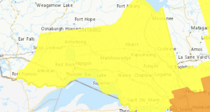
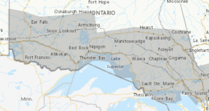
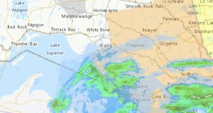
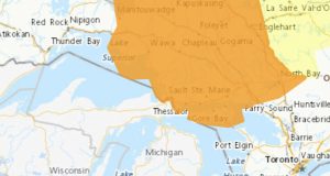