 Wawa-news.com Local and Regional News
Issued: 5:47 AM EST Tuesday 27 February 2024
Winter Storm Warning in effect:
- Chapleau – Gogama
- Chapleau – Missinaibi Lake
- Gogama – Foleyet
- Geraldton – Manitouwadge – Hornepayne
- Geraldton – Longlac – Caramat
- Manitouwadge – Hornepayne
- Nakina – Aroland – Pagwa
A winter storm will affect the area beginning tonight.
Hazards:
- Total snowfall and ice pellet accumulations of 15 to 20 cm.
- A period of freezing rain with 1 to 3 millimetres of ice accretion.
- A flash freeze.
- Reduced visibility in heavy snow and blowing snow.
Timing: Beginning this evening ending Wednesday night.
Discussion: Precipitation will begin as showers along with the risk of thunderstorms this afternoon and evening. This evening or near midnight the rain will transition over to freezing rain or ice pellets and then over to snow Wednesday morning. During the transition from liquid to frozen precipitation, temperatures will rapidly drop into the minus teens leading to the potential of a flash freeze.
Dangerous travel conditions are expected as roads may become icy with the freezing rain and flash freeze.
Visibility will be suddenly reduced to near zero at times in heavy snow and blowing snow. Surfaces such as highways, roads, walkways and parking lots may become icy and slippery.
Consider postponing non-essential travel until conditions improve. If visibility is reduced while driving, turn on your lights and maintain a safe following distance.
A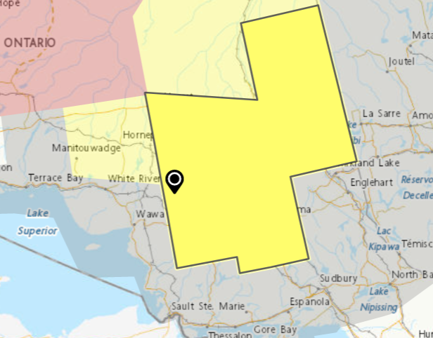 winter storm is expected to affect the area from Tuesday afternoon to Wednesday.
(Manitouwadge, Hornepayne, Missinaibi, Chapleau, Gogama – Foleyet…)
Hazards:
- Total snowfall and ice pellet accumulations of 15 to 25 centimetres.
- Risk for freezing rain with 1 to 3 millimetres of ice accretion.
- A flash freeze.
- Reduced visibility in heavy snow and blowing snow.
Timing:
Beginning Tuesday afternoon ending Wednesday night.
Discussion:
A strong low-pressure system will affect the area beginning on Tuesday through Wednesday bringing with it a multitude of precipitation types. Precipitation will begin as periodic showers along with the risk of thunderstorms Tuesday afternoon and evening. Late Tuesday night or early Wednesday morning, the rain will transition over to freezing rain or ice pellets and then over to snow through the day Wednesday. During the transition from liquid to frozen precipitation, temperatures will rapidly drop into the minus teens leading to the potential of a flash freeze.
Dangerous travel conditions are expected as roads may become icy with the freezing rain and flash freeze. Visibility will also be reduced in heavy snow and blowing snow.
Rapidly accumulating snow could make travel difficult over some locations. Visibility may be suddenly reduced at times in heavy snow. Surfaces such as highways, roads, walkways and parking lots may become icy and slippery. Cold conditions are possible with severe wind chill values.
If you must travel, keep others informed of your schedule and destination and carry an emergency kit and mobile phone. Public Safety Canada encourages everyone to make an emergency plan and get an emergency kit with drinking water, food, medicine, a first-aid kit and a flashlight. For information on emergency plans and kits go to getprepared.gc.ca.
Orange Alert = Severe weather
Red Alert = Very dangerous and possibly life-threatening weather
For road conditions and other traveller information from the Ministry of Transportation, visit https://www.ontario.ca/511, or call 5-1-1.
Please continue to monitor alerts and forecasts issued by Environment Canada. To report severe weather, send an email to [email protected] or tweet reports using #ONStorm.
- Heat Warning (Chapleau – Missinaibi Lake) - July 1, 2026
- Heat Warning (Searchmont – Montreal River Harbour – Batchawana Bay) - July 1, 2026
- Heat Warning (White River – Dubreuilville) - July 1, 2026