Wawa-news.com Local and Regional News
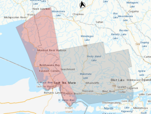 Snow Squall Warning in effect for:
- Sault Ste. Marie – Superior East
Snow squalls are expected. Under the snow squall bands, visibilities will be significantly reduced due to the heavy snow combined with blowing snow, and snow will quickly accumulate.
Hazards: Locally heavy snowfall with total amounts of 20 to 30 cm. Near zero visibility at times in heavy snow and blowing snow.
Timing: Today into Wednesday morning.
Discussion: In the wake of a passing cold front, intense snow squalls are expected today and tonight east of Lake Superior. Snow squalls will weaken Wednesday morning.
Travel is expected to be dangerous along portions of highway 17 between Sault Ste. Marie and Wawa during this event and is not recommended. Visibility will be suddenly reduced to near zero at times in heavy snow and blowing snow.
Rapidly accumulating snow could make travel difficult over some locations. Road closures are possible. If visibility is reduced while driving, slow down, watch for tail lights ahead and be prepared to stop.

Orange Alert = Severe weather
Red Alert = Very dangerous and possibly life-threatening weather
For road conditions and other traveller information from the Ministry of Transportation, visit https://www.ontario.ca/511, or call 5-1-1.
Please continue to monitor alerts and forecasts issued by Environment Canada. To report severe weather, send an email to [email protected] or tweet reports using #ONStorm.
- Yellow Frost Warning (Wawa – Pukaskwa Park & area) - September 19, 2026
- Gusty southwesterly winds expected (Marathon – Schreiber) Ended - September 15, 2026
- Gusty southwesterly winds expected (Wawa – Pukaskwa Park) - September 15, 2026