Wawa-news.com Local and Regional News
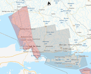 Snow squalls expected Monday morning into Tuesday morning.
Hazards: Heavy snowfall with local accumulations of 15 to 25 cm. Reduced visibility at times in heavy snow and blowing snow.
Timing: Monday morning into Tuesday morning.
Discussion: Lake effect snow squalls are forecast beginning Monday morning.
Local snowfall accumulations could reach 15 to 25 cm by Tuesday. Strong northwesterly winds will accompany these snow squalls resulting in significantly reduced visibility at times in heavy snow and blowing snow.
Travel is expected to be significantly impacted, and people are encouraged to monitor future forecasts for further details. Travel may be hazardous due to sudden changes in the weather. Surfaces such as highways, roads, walkways and parking lots may become difficult to navigate due to accumulating snow. Road closures are possible.
Please continue to monitor alerts and forecasts issued by Environment Canada. To report severe weather, send an email to [email protected] or tweet reports using #ONStorm.

Orange Alert = Severe weather
Red Alert = Very dangerous and possibly life-threatening weather
For road conditions and other traveller information from the Ministry of Transportation, visit https://www.ontario.ca/511, or call 5-1-1.
Please continue to monitor alerts and forecasts issued by Environment Canada. To report severe weather, send an email to [email protected] or tweet reports using #ONStorm.
- Yellow Frost Warning (Wawa – Pukaskwa Park & area) - September 19, 2026
- Gusty southwesterly winds expected (Marathon – Schreiber) Ended - September 15, 2026
- Gusty southwesterly winds expected (Wawa – Pukaskwa Park) - September 15, 2026