Wawa-news.com Local and Regional News
WINTER STORM WATCH FOR NORTHERN ONTARIO
ISSUED BY ENVIRONMENT CANADA AT 3:42 P.M. EST TUESDAY 25 DECEMBER 2018.
———————————————————————
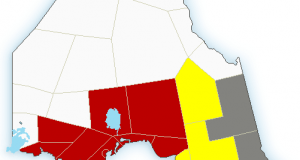
WINTER STORM WATCH FOR:
CITY OF THUNDER BAY
IGNACE – ENGLISH RIVER
FORT FRANCES – RAINY LAKE
ATIKOKAN – UPSALA – QUETICO
SUPERIOR WEST
GULL BAY – BLACK STURGEON LAKE
BEARDMORE – JELLICOE – MACDIARMID
GERALDTON – LONGLAC – CARAMAT
MANITOUWADGE – HORNEPAYNE
NIPIGON – MARATHON – SUPERIOR NORTH
WAWA – WHITE RIVER – PUKASKWA.
———————————————————————
==DISCUSSION==
A major winter storm will affect the regions Wednesday night through Friday with heavy snow and blowing snow.
Snow accumulations may be in the 15 to 25-centimetre range. Strong Northeasterly winds with gusts to 60 km/h may reduce visibility at times.
The storm is due to a Colorado Low which will make its way into Northwestern Ontario late Wednesday. The heaviest snow will end late Thursday, however blowing snow may persist through Friday afternoon.
Rapidly accumulating snow could make travel difficult over some locations. Travel is expected to be hazardous due to reduced visibility in some locations. If you must travel, keep others informed of your schedule and destination and carry an emergency kit and a mobile phone.
Winter storm watches are issued when multiple types of severe winter weather are expected to occur together.
Please continue to monitor alerts and forecasts issued by Environment Canada. To report severe weather, send an email to Onstorm(at)canada.ca or tweet reports using (hash)onstorm.

- Saturday Morning News – March 9 - March 9, 2024
- Hwy 101 (Wawa to Chapleau) OPEN - June 17, 2023
- Hwy 631 (White River to Hwy 11) OPEN - January 17, 2023