Wawa-news.com You can't hear the 'big picture'!
Jun 14, 2017 @ 08:49
Red Pine Exploration Inc. has received the final results for holes SD-17-73 and SD-17-74, which were drilled as part of the new 20,000 metres drilling program in the southern extension of the historic Minto Mine. As announced on July 8, 2017, the Company expects to continuously release results throughout the summer from its backlog of drill results and geological data.
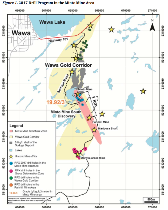
Highlights include (see Table 1 and Figures 1 and 2 below):
| • | Discovery of a high-grade quartz zone in the southern extension of the Minto Mine structure: | |
| – | SD-17-73 contains 19.92 g/t gold over 3 metres | |
| – | SD-17-74 contains 4.75 g/t gold over 3 metres | |
| • | The quartz zone discovered in the southern extension of the Minto Mine Structure has been intersected in 13 boreholes (results pending) covering an area of 250m x 120m; | |
| • | Visible gold has been observed in 12 of 13 boreholes | |
Quentin Yarie, President and Chief Executive Officer of Red Pine stated, “We are quite impressed by the continuity of the quartz zone in the southern extension of the Minto Mine Structure. So far, the 13 holes drilled in the Structure intersected the same zone at its predicted location and visible gold was observed in every hole but one. We are excited by this discovery and are now moving forward to aggressively explore the Minto Mine Structure along an interpreted 2.2 km-long strike length based on historic and recent drilling data.”
Minto Mine Structure Results
The on-going drilling into the Minto Mine Structure is designed to test the extension of this structure south and down-dip of the former Minto Mine (historic production of 23,000 ounces @ 12.56 g/t gold)(1).
In the southern extension of the Minto Mine Structure, thirteen boreholes intersected the newly discovered Minto Mine South Zone, which has now been defined over an approximate area of 250 m x 120 m. This new zone remains open at depth and is will be further tested as part of the on-going drill program. The deepest intersection obtained so far in the Minto Mine South Zone is 150 metres below surface in SD-17-89. In hole SD-17-73, the Minto Mine Structure is overlain by subsidiary quartz veins, including some containing visible gold that were observed at 18 metres and 44 metres. Hole SD-17-74 was drilled as an 80 metres lateral step-out along the Minto A structure from SD-17-73. In SD-17-74, in addition to intersecting the Minto Mine Structure, a mineralized shear zone was also intersected on the edge of the quartz system.
Depth Potential of the Minto Mine Structure
Historic drilling completed in 2007 indicates that gold mineralization in the Minto Mine Structure extends up to 560 metres below surface, where hole 07-389 intersected 7.24 g/t gold over 3 metres (Figure 2). Further discoveries are anticipated since, except for the immediate vicinity of the Parkhill Mine, almost the entirety of the interpreted 2.2 km strike length of the Minto Mine Structure south of the former Minto Mine has never been drill tested.
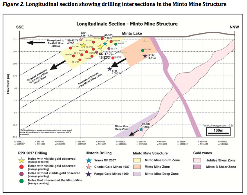
SD-17-92, drilled to test the down-plunge extension of the Minto Mine Zone, successfully intersected a quartz vein containing visible gold that is interpreted as the down-plunge extension of the zone (Figure 2). The mineralized quartz vein was intersected 30 metres below the Minto Mine. Combined with the historic intersection in borehole S183, hole SD-17-92 indicates that the Minto Mine Zone could extend deeper than the lowermost limits of the former Minto Mine.
Table 1. Highlights of the spring 2017 drilling results in the Minto Mine area
| Hole | From (m) |
To (m) |
Length (m)* |
Gold (g/t) |
Gold Zone |
| 18.16 | 19.16 | 1 | 1.38 | Quartz vein | |
| SD-17-73 | 43.28 | 44.28 | 1 | 3.35 | |
| 89.87 | 92.87 | 3 | 19.92 | Minto Mine South Zone | |
| SD-17-74 | 107.61 | 110.61 | 3 | 4.75 | |
| 147.24 | 150.2 | 2.96 | 0.5 | Unnamed shear zone |
| *Assay results reported over intersection length estimated in the Minto Mine Structure to represent >85% true width. |
Wawa Gold Project
The Wawa Gold property package consists of over 5,000 hectares and hosts several former mines with a combined historic production of 120,000 oz gold(1). To date, the largest gold deposit on the property is the Surluga Deposit, which hosts a NI 43-101 Inferred Resource of 1,088,000 oz gold at an average grade of 1.71 g/t using a 0.5 g/t cut-off contained within 19.82 million tonnes(2).
Exploration work by Red Pine during the past 16 months has involved the ongoing sampling of 42,000 metres of historic core that was never sampled by previous operators of the project (initiated in February 2016) and aggressive drilling campaigns.
In March 2017, the Company completed a 6,000 metres of drilling and immediately initiated a new 10,000 metres drilling program. This was quickly expanded to 20,000 metres as a second drill was added to the campaign. The aggregate 20,000 metres drill program is designed to potentially expand the size of the existing inferred gold resource and connect other zones of gold mineralization (the Wawa Gold Corridor) recently discovered through drilling and other exploration techniques on the large Wawa Gold Project property.
The Company is well positioned to fund its share of the Wawa Gold exploration program. As such, the sampling and drill programs are expected to continue throughout 2017.
| Highlights | ||
| • | 100% owned land position between JVA | |
| • | 2 km southeast of the Municipality of Wawa, Ontario, close to roads, power and other infrastructure | |
| • | 8 past producing mines on property with historical production of 120,000 oz gold at 9.04 g/t average grade(1) | |
| >1M oz Inferred Gold Resource at 1.71 g/t (0.5 g/t cut-off)(2) | ||
| – | Near surface mineralization | |
| – | Open in all directions | |
| Considerable Growth Potential | ||
| – | Potential for multi-million ounces resource | |
| – | Newly discovered high-grade gold zones in many areas on property | |
| – | Gold mineralization extends 5 km in length | |
| Preliminary Metallurgical Study Underway | ||
| – | Optimization of gold and silver recoveries | |
On-site Quality Assurance/Quality Control (“QA/QC”) Measures
Drill core samples were transported in security-sealed bags for analyses to SGS in Cochrane, Ontario. Individual samples are labeled, placed in plastic sample bags and sealed. Groups of samples are then placed into durable rice bags and then shipped. The remaining coarse reject portions of the samples remain in storage if further work or verification is needed.
Red Pine has implemented a quality-control program to comply with best practices in the sampling and analysis of drill core. As part of its QA/QC program, Red Pine inserts external gold standards (low to high grade) and blanks every 20 samples in addition to random standards, blanks, and duplicates.
Qualified Person
Quentin Yarie, P Geo. is the qualified person responsible for preparing, supervising and approving the scientific and technical content of this news release.
1Mineral Resource Statement, Surluga-Jubilee Gold Deposit, Wawa Gold Project, Ontario, SRK Consulting (Canada) Inc. (effective May 26, 2015)). The report is available on www.SEDAR.com under Red Pine’s profile.
(2) NI 43-101 inferred resource of 1,088,000 ounces of gold at a 1.71 grams per tonne (g/t) using a 0.40 g/t gold cut-off grade for pit-constrained and 2.50 g/t gold cut-off grade for underground-constrained resources, contained in 19.82 million tonnes open along strike and at depth. The Cut-off grades are based on a gold price of US$1,250 per once and a gold recovery of 95 percent (Mineral Resource Statement, Surluga-Jubilee Gold Deposit, Wawa Gold Project, Ontario, SRK Consulting (Canada) Inc (effective May 26, 2015)).
- Red Pine Updates on its 2022 Phase 1 Drill Program – Expands Drill Program - January 6, 2022
- Red Pine Intersects 3.08 g/t Gold over 55.66m at Wawa Project - November 9, 2021
- Red Pine Makes New Discovery at Surluga Deposit - May 13, 2020