 Wawa-news.com Local and Regional News
Mar 18, 2026 at 20:04 Special Weather Statement 4:19 PM EDT Wednesday 18 March 2026 Difficult travel conditions expected. What: Snowfall accumulations of 10 to 15 cm. Reduced visibility in snow and blowing snow. Wind gusts up to 50 km/h. When: Continuing into tonight. Additional information: Snowfall accumulations up to 15 cm are possible over higher elevations. Conditions are expected ...
Read More »Weather Alerts
Difficult travel conditions (Agawa – Lake Superior Park)
Mar 18, 2026 at 20:04 Special Weather Statement 4:19 PM EDT Wednesday 18 March 2026 Difficult travel conditions expected. What: Snowfall accumulations of 10 to 15 cm. Reduced visibility in snow and blowing snow. Wind gusts up to 50 km/h. When: Continuing into tonight. Additional information: Snowfall accumulations up to 15 cm are possible over higher elevations. Conditions are expected ...
Read More »Freezing Drizzle Continues (Montreal River Harbour – Searchmont)
Mar 18, 2026 at 20:04 Yellow Advisory – Freezing Drizzle 8:01 PM EDT Wednesday 18 March 2026 Impact Level: Moderate Forecast Confidence: High Freezing drizzle leading to icy surfaces continues. Hazard: Freezing drizzle leading to light ice build-up and slippery surfaces. When: Continuing this evening and ending overnight. Roads, walkways, and other surfaces will likely become icy and slippery. Icy ...
Read More »Major winter storm continues (Chapleau – Missinaibi Lake)
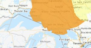
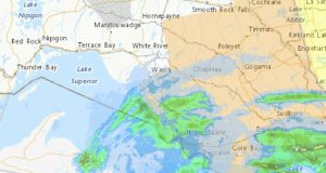
Mar 16, 2026 at 05:46 Orange Warning – Winter Storm 5:12 AM EDT Monday 16 March 2026 Impact Level: Extreme Forecast Confidence: High Major winter storm continues. What: Total snowfall accumulations of 30 to 50 cm. Near zero visibility in heavy snow and blowing snow. Northeasterly wind gusts of 70 to 80 km/h. When: Continuing through tonight. Additional information: Precipitation ...
Read More »Major winter storm continues (Agawa – Lake Superior Park)
Mar 16, 2026 at 05:46 Orange Warning – Winter Storm 5:12 AM EDT Monday 16 March 2026 Impact Level: Extreme Forecast Confidence: High Major winter storm continues. What: Total snowfall accumulations of 30 to 50 cm. Near zero visibility in heavy snow and blowing snow. Northeasterly wind gusts of 70 to 80 km/h. When: Continuing through tonight. Additional information: Precipitation ...
Read More »Major winter storm continues (Gogama – Foleyet)
Mar 16, 2026 at 05:46 Orange Warning – Winter Storm 5:12 AM EDT Monday 16 March 2026 Impact Level: Extreme Forecast Confidence: High Major winter storm continues. What: Total snowfall accumulations of 30 to 50 cm. Near zero visibility in heavy snow and blowing snow. Northeasterly wind gusts of 70 to 80 km/h. When: Continuing through tonight. Additional information: Precipitation ...
Read More »Major winter storm continues (Sault Ste. Marie – St. Joseph Island)
Mar 16, 2026 at 05:46 Orange Warning – Winter Storm 5:12 AM EDT Monday 16 March 2026 Impact Level: Extreme Forecast Confidence: High Major winter storm continues. What: Total snowfall accumulations of 30 to 50 cm. Near zero visibility in heavy snow and blowing snow. Northeasterly wind gusts of 70 to 80 km/h. When: Continuing through tonight. Additional information: Precipitation ...
Read More »Major winter storm continues (Montreal River Harbour – Searchmont)
Mar 16, 2026 at 05:46 Orange Warning – Winter Storm 5:12 AM EDT Monday 16 March 2026 Impact Level: Extreme Forecast Confidence: High Major winter storm continues. What: Total snowfall accumulations of 30 to 50 cm. Near zero visibility in heavy snow and blowing snow. Northeasterly wind gusts of 70 to 80 km/h. When: Continuing through tonight. Additional information: Precipitation ...
Read More »Major winter storm continues (Manitouwadge – Hornepayne)
Mar 16, 2026 at 05:46 Orange Warning – Winter Storm 5:12 AM EDT Monday 16 March 2026 Impact Level: Extreme Forecast Confidence: High Major winter storm continues. What: Total snowfall accumulations of 20 to 30 cm. Near zero visibility in heavy snow and blowing snow. Northeasterly wind gusts of 70 to 80 km/h. When: Continuing through today. Additional information: 10 ...
Read More »Major winter storm continues (White River – Dubreuilville)
Mar 16, 2026 at 05:46 Orange Warning – Winter Storm 5:12 AM EDT Monday 16 March 2026 Impact Level: High Forecast Confidence: High Major winter storm continues. What: Total snowfall accumulations of 20 to 30 cm. Near zero visibility in heavy snow and blowing snow. Northeasterly wind gusts of 70 to 80 km/h. When: Continuing through today. Additional information: 10 ...
Read More »Major winter storm continues (Wawa – Pukaskwa Park)
Mar 16, 2026 at 05:46 Orange Warning – Winter Storm 5:12 AM EDT Monday 16 March 2026 Impact Level: Extreme Forecast Confidence: High Major winter storm continues. What: Total snowfall accumulations of 20 to 30 cm. Near zero visibility in heavy snow and blowing snow. Northeasterly wind gusts of 70 to 80 km/h. When: Continuing through today. Additional information: 10 ...
Read More »Special Weather Statement – Heavy snow (Manitouwadge – Hornepayne)
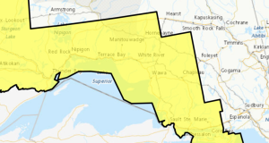
Mar 7, 2026 at 05:54 Special Weather Statement 5:37 AM EST Saturday 7 March 2026 Snow, heavy at times, likely. What: Heavy snow with accumulations of 10 to 15 possible. When: Beginning this morning and ending this afternoon. Additional information: Snow, heavy at times, is expected along a cold front moving through the area. Highway 11 may be affected.
Read More »Freezing Drizzle Expected Tonight (Wawa – Pukaskwa Park) ENDED
Mar 6, 2026 at 08:49 8:48 AM EST Friday 6 March 2026 No alerts in effect. Mar 5, 2026 at 18:45 Yellow Advisory – Freezing Drizzle 6:26 PM EST Thursday 5 March 2026 Impact Level: Moderate Forecast Confidence: High Areas of freezing drizzle are expected. What: Freezing drizzle resulting in icy and slippery conditions. When: Beginning overnight or early Friday ...
Read More »Freezing Drizzle Expected Tonight (White River – Dubreuilville) ENDED
Mar 6, 2026 at 08:48 8:47 AM EST Friday 6 March 2026 No alerts in effect. Mar 5, 2026 at 18:45 Yellow Advisory – Freezing Drizzle 6:26 PM EST Thursday 5 March 2026 Impact Level: Moderate Forecast Confidence: High Areas of freezing drizzle are expected. What: Freezing drizzle resulting in icy and slippery conditions. When: Beginning overnight or early Friday ...
Read More »Freezing Drizzle Expected Tonight (Searchmont – Montreal River Harbour) ENDED
Mar 6, 2026 at 08:46 8:46 AM EST Friday 6 March 2026 No alerts in effect. Mar 5, 2026 at 18:45 Yellow Advisory – Freezing Drizzle 6:26 PM EST Thursday 5 March 2026 Impact Level: Moderate Forecast Confidence: High Areas of freezing drizzle are expected. What: Freezing drizzle resulting in icy and slippery conditions. When: Beginning overnight or early Friday ...
Read More »