Wawa-news.com Local and Regional News
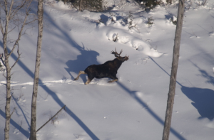 The Ministry of Natural Resources and Forestry is conducting moose aerial inventory surveys in wildlife management units across Ontario to help monitor moose populations.
Between December and February, staff are using aircraft to look for moose and their tracks in fresh, deep snow. Survey information about the number, age and sex of moose is used to inform moose and habitat management.
Most of our survey flights will take place over Northern Ontario, near Kenora, Fort Frances, Dryden, Geraldton, Nipigon, Manitouwadge, Wawa, Chapleau, Timmins, Kirkland Lake, Moosonee and Hearst. We will also survey areas around Parry Sound, Bracebridge, Bancroft, Pembroke and North Bay.
As is the case every year, survey completion depends on appropriate weather conditions and adequate snow to ensure staff can reliably detect moose and their tracks from aircraft.
More information about moose management and monitoring is available at www.ontario.ca/page/moose-population-management. Follow Ontario Fish and Wildlife on social media for seasonal moose aerial inventory updates.
- Northeast Forest Fire Region Update – November 1 - November 1, 2025
- Northeast Forest Fire Region Update – October 31 - October 31, 2025
- Northeast Forest Fire Region Update – October 30 - October 30, 2025