Wawa-news.com Local and Regional News
 Feb 5, 2021 at 21:56
Snow squall warning in effect for:
- Agawa – Lake Superior Park
- Searchmont – Montreal River Harbour – Batchawana Bay
Snow squalls will persist tonight and continue through Saturday night.
Local snowfall accumulations of 15 to 30 cm are expected in these snow squalls. Areas between Montreal River and Batchawana Bay could possibly reach 40 cm.
The combination of winds gusting to 60 km/h and snow will result in lowered visibility in blowing snow.
Visibility will be suddenly reduced to near zero at times in heavy snow and blowing snow. If visibility is reduced while driving, turn on your lights and maintain a safe following distance. Rapidly accumulating snow could make travel difficult over some locations. Consider postponing non-essential travel until conditions improve. Road closures are possible.
Please continue to monitor alerts and forecasts issued by Environment Canada. To report severe weather, send an email to [email protected] or tweet reports using #ONStorm.
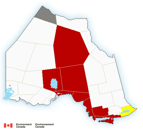
9:24 PM EST Friday 05 February 2021
Snow squall warning in effect for:
- Sault Ste. Marie – St. Joseph Island
Snow squalls will affect the region after midnight through Saturday.
Snow squalls are currently to the north of the area, however as winds become more northwesterly overnight, the snow squalls will shift southward into the region.
Local snowfall accumulations of 15 cm are expected in these snow squalls. The combination of wind gusting to 60 km/h and snow will result in lowered visibility in blowing snow.
The snow squalls are expected to move north of the region once again late Saturday afternoon.
Travel is expected to be hazardous due to reduced visibility in some locations. Rapidly accumulating snow could make travel difficult over some locations.
Please continue to monitor alerts and forecasts issued by Environment Canada. To report severe weather, send an email to [email protected] or tweet reports using #ONStorm.
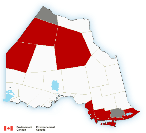
Feb 5, 2021 at 15:11
Snow squall warning in effect for:
- Agawa – Lake Superior Park
- Sault Ste. Marie – St. Joseph Island
- Searchmont – Montreal River Harbour – Batchawana Bay
Snow squalls are expected. Under the snow squall bands, visibilities will be significantly reduced due to the heavy snow combined with blowing snow, and snow will quickly accumulate.
Snow squalls are likely to move in by mid afternoon and continue through Saturday.
Local snowfall accumulations of 15 to 30 cm are expected in these snow squalls. Areas near Montreal River and Batchawana Bay could possibly reach 40 cm.
The combination of strong and gusty winds reaching up to 60 km/h and heavy snow at times will result in a significant reduction in visibility in local blowing snow.
Prepare for quickly changing and deteriorating travel conditions. Visibility will be suddenly reduced to near zero at times in heavy snow and blowing snow. If visibility is reduced while driving, turn on your lights and maintain a safe following distance. If visibility is reduced while driving, slow down, watch for tail lights ahead and be prepared to stop. Consider postponing non-essential travel until conditions improve.
Snow squall warnings are issued when bands of snow form that produce intense accumulating snow or near zero visibilities.
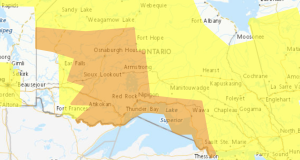
Feb 5, 2021 at 08:05
 Snowfall warning in effect: (ended at 3:04 p.m.)
- Wawa – Pukaskwa Park
- Marathon – Schreiber
- Nipigon – Rossport
Heavy snow continues today.
Locally heavy snowfall continues today and will taper to flurries early this evening. Additional snowfall accumulations of 5 to 10 cm is expected today.
Strong northwesterly winds gusting up to 50 km/h will develop this morning resulting in localized areas of blowing snow through the day.
Rapidly accumulating snow could make travel difficult over some locations. Rapidly accumulating snow will make travel difficult. Surfaces such as highways, roads, walkways and parking lots may become difficult to navigate due to accumulating snow.
Winter Weather Travel Advisory in effect for today (ended at 3:04 p.m.)
- White River – Dubreuilville
Snow, heavy at times, will continue this morning before tapering to periods of light snow this afternoon. An additional 5 to 10 cm of snowfall is expected today.
Poor winter driving conditions especially on Highway 17 are expected due to accumulating snow and low visibility. Motorists should consider changing travel plans accordingly.

- Air Quality – Orange Alert (July 18) - July 18, 2026
- Northwest Forest Fire Update – July 17 - July 17, 2026
- Northeast Forest Fire Update – July 17 - July 17, 2026