Wawa-news.com Local and Regional News
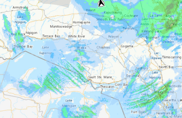
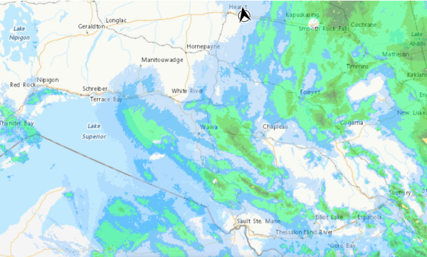
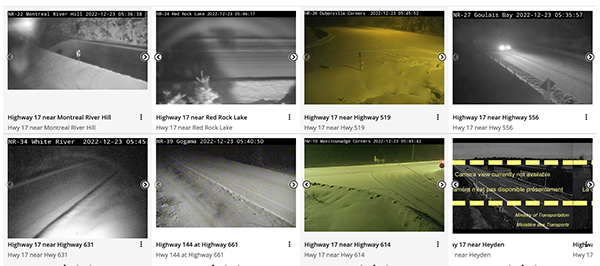
The weather conditions are changing, and this is not an entire compliation of weather warnings. Wawa-news is concentrating information for those who are travelling through the Wawa area.
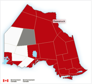
Environment Canada is warning “Consider postponing non-essential travel until conditions improve. Surfaces such as highways, roads, walkways and parking lots may become difficult to navigate due to accumulating snow. Visibility will be suddenly reduced to near zero at times in heavy snow and blowing snow. If visibility is reduced while driving, slow down, watch for tail lights ahead and be prepared to stop. Public Safety Canada encourages everyone to make an emergency plan and get an emergency kit with drinking water, food, medicine, a first-aid kit and a flashlight. For information on emergency plans and kits go to http://www.getprepared.gc.ca.
Please continue to monitor alerts and forecasts issued by Environment Canada. To report severe weather, send an email to [email protected] or tweet reports using #onstorm.”
Dec 24, 2022 at 08:18
Wawa – Pukaskwa Park
White River – Dubreuilville
Winter storm warning in effect. Major winter storm continues today. With total snowfall amounts of 30 to 40 cm by tonight. Significantly reduced visibility in heavy snow and blowing snow. Wind gusts up to 70 km/h and possible blizzard conditions.
Snow is expected to ease during the day, and conditions will improve somewhat. However, strong northwest winds will continue today, resulting in widespread blowing snow. Strong winds and blowing snow are expected to diminish tonight.
Searchmont – Montreal River Harbour – Batchawana Bay – ENDED 16:32
Strong northwest winds will develop this morning off Lake Superior. Blowing snow is also expected as snowfall continues. Winds are forecast to diminish tonight.
Sault Ste. Marie – St. Joseph Island
In the wake of a winter storm, snow squalls will develop and affect the Sault Ste. Marie area. Local snowfall accumulations of 15 to 25 cm are possible by Sunday, with a majority of the snow falling today and tonight. Strong northwest winds in tandem with squalls will result in blowing snow and very poor visibility at times. Snow squalls and strong winds are expected to gradually ease on Sunday.
Geraldton – Longlac – Caramat
Manitouwadge – Hornepayne
Nakina – Aroland – Pagwa
Winter storm warning in effect. Snow is expected to ease during the day, and conditions will improve somewhat. However, strong northwest winds will continue today, resulting in widespread blowing snow. Strong winds and blowing snow are expected to diminish tonight.
Dec 23, 2022 at 11:03
WINTER STORM WARNING (10:55 a.m.):
- Sault Ste. Marie – St. Joseph Island
- Searchmont – Montreal River Harbour – Batchawana Bay
- Greater Sudbury And Vicinity
- Elliot Lake – Ranger Lake
- Manitoulin – Blind River – Killarney.
Major winter storm continues into Saturday. Total snowfall amounts of 25 to 40 cm by Saturday morning. Snow squalls are possible Saturday into Monday for the Sault Ste. Marie area. Snow heavy at times will continue today. The snow is forecast to taper off on Saturday. Strong northwesterly winds may then generate snow squalls for the Sault Ste. Marie area, bringing additional snowfall. Near zero visibility is possible at times.
WINTER STORM WARNING (10:55 a.m.):
- Agawa – Lake Superior Park
- Kapuskasing – Hearst – Smooth Rock Falls
- Timmins – Cochrane
- Chapleau – Gogama
- Kirkland Lake – Temiskaming Shores – Temagami
Significant winter storm continues into Saturday. Travel will be hazardous. Total snowfall amounts of 20 to 35 cm by Saturday morning. Reduced visibility in heavy snow and local blowing snow.
BLIZZARD WARNING (as of 10:37 a.m.)
- City Of Thunder Bay
- Cloud Bay – Dorion
- Gull Bay – Black Sturgeon Lake
- Beardmore – Jellicoe – MacDiarmid
- Nipigon – Rossport
Dangerous blizzard this afternoon into Saturday. Travel will be extremely difficult and is not advised.
Strong winds and blizzard conditions with gusts of 70 to 80km/h are expected to develop late this afternoon and continue until Saturday afternoon.
Falling snow combined with strengthening northwest winds this afternoon will create very dangerous blizzard conditions. Winds will remain strong through Saturday, however snow is expected to taper off Saturday afternoon. Conditions may improve somewhat, although extensive blowing snow will likely continue into Saturday night.
Travel is expected to be very difficult or impossible due to near-zero visibility. Visibility will be suddenly reduced to near zero at times in heavy snow and blowing snow. Road closures are possible. Anyone who is not dressed warmly is at risk of frostbite and hypothermia in cold weather. Ensure that shelter is provided for pets and outdoor animals.
Dec 23, 2022 at 06:48
 BLIZZARD WARNING (as of 6:46 a.m.)
- City Of Thunder Bay
- Cloud Bay – Dorion
- Gull Bay – Black Sturgeon Lake
- Beardmore – Jellicoe – MacDiarmid
- Nipigon – Rossport
Dangerous blizzard with wind gusts of 70 – 80km/h is expected this afternoon into Saturday. Travel will be extremely difficult and is not advised.
Strong winds and blizzard conditions developing late this afternoon and continuing until Saturday afternoon.
Falling snow combined with strengthening northwest winds this afternoon will create very dangerous blizzard conditions. Winds will remain strong through Saturday, however snow is expected to taper off Saturday afternoon. Conditions may improve somewhat, although extensive blowing snow will likely continue into Saturday night.
Travel is expected to be very difficult or impossible due to near-zero visibility. Visibility will be suddenly reduced to near zero at times in heavy snow and blowing snow. Road closures are possible. Anyone who is not dressed warmly is at risk of frostbite and hypothermia in cold weather. Ensure that shelter is provided for pets and outdoor animals.
WINTER STORM WARNING (6:17 a.m.):
- City Of Thunder Bay
- Cloud Bay – Dorion
- Lake Nipigon – Wabakimi
- Geraldton – Manitouwadge – Hornepayne
- Nipigon – Marathon – Superior North
- Wawa – White River – Pukaskwa
- Fraserdale – Pledger Lake.
A major winter storm continues through Saturday. Total snowfall amounts of 30 to 40 cm by Saturday night. Significantly reduced visibility in heavy snow and blowing snow. Wind gusts up to 70 km/h and possible blizzard conditions. Snow, at times heavy, tapering off to light snow on Saturday. Strong winds and possible blizzard conditions developing this afternoon and continuing into Saturday.
WINTER STORM WARNING (6:17 a.m.):
- Sault Ste. Marie – St. Joseph Island
- Searchmont – Montreal River Harbour – Batchawana Bay
- Greater Sudbury And Vicinity
- Elliot Lake – Ranger Lake
- Manitoulin – Blind River – Killarney.
Major winter storm continues into Saturday. Total snowfall amounts of 25 to 40 cm by Saturday morning. Snow squalls are possible Saturday into Monday for the Sault Ste. Marie area. Snow heavy at times will continue today. The snow is forecast to taper off on Saturday. Strong northwesterly winds may then generate snow squalls for the Sault Ste. Marie area, bringing additional snowfall. Near zero visibility is possible at times.

- Tuesday Morning News – July 21st - July 21, 2026
- Monday Morning News – July 20th - July 20, 2026
- Wawa FD called to Backyard Bonfire during RFZ - July 19, 2026