 Wawa-news.com Local and Regional News
 6:11 PM EDT Wednesday 03 October 2018
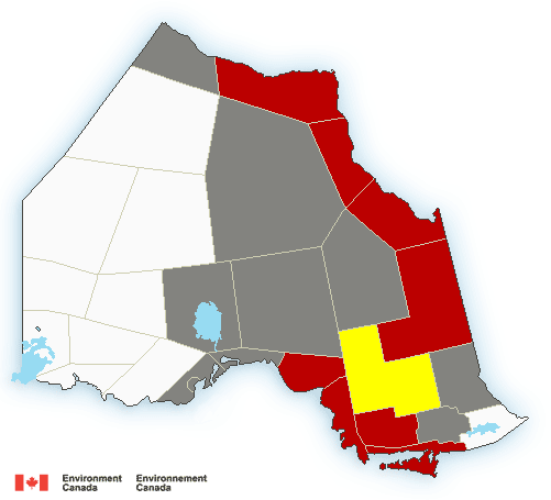
Rainfall warning in effect for:
- Wawa – Pukaskwa Park
- White River – Dubreuilville
Rain, at times heavy, is expected.
Rain will continue into the overnight hours. Total rainfall amounts of 30 to 50 mm are expected with the heaviest rain falling this evening. Thunderstorms are also possible which would contribute to total rainfall amounts in excess of 50 mm.
This rain is the result of a developing low pressure system that is rapidly intensifying as it tracks over Northern Ontario.
Heavy downpours can cause flash floods and water pooling on roads. Localized flooding in low-lying areas is possible. Watch for possible washouts near rivers, creeks and culverts.
Watches
5:08 PM EDT Wednesday 03 October 2018
Severe thunderstorm watch in effect for:
- Wawa – Pukaskwa Park
- White River – Dubreuilville
Conditions are favourable for the development of dangerous thunderstorms that may be capable of producing damaging wind gusts and large hail.
Areas of thunderstorms are expected to move eastward across the regions this evening. Damaging wind gusts and large hail may be associated with some of these storms.
Very strong wind gusts can damage buildings, down trees and blow large vehicles off the road. Lightning kills and injures Canadians every year. Remember, when thunder roars, go indoors!
Severe thunderstorm watches are issued when atmospheric conditions are favourable for the development of thunderstorms that could produce one or more of the following: large hail, damaging winds, torrential rainfall.
The Office of the Fire Marshal and Emergency Management recommends that you take cover immediately if threatening weather approaches.
Statements
3:59 PM EDT Wednesday 03 October 2018
Special weather statement in effect for:
- Wawa – Pukaskwa Park
- White River – Dubreuilville
Strong winds expected tonight.
A vigorous cold front will sweep through the area overnight or early Thursday morning. Northwesterly wind gusts to 70 or 80 km/h will develop as this front passes. Winds will weaken Thursday morning.
These winds may be capable of tossing loose objects and causing tree branches to break.
The effects of the wind may be increased in areas where the ground is very saturated giving the potential for local power outages.

- Friday Morning News – July 31st - July 31, 2026
- Thursday Morning News – July 30th - July 30, 2026
- Power Outage in White River, Mobert and Hemlo – RESTORED - July 29, 2026