Wawa-news.com Local and Regional News
Dec 6, 2017 @ 19:42
Snow squall warning for Lake Superior (Provincial Park) ended by Environment Canada (EC) at 06:28 p.m.
Snow squall warning for Chapleau ended by Environment Canada (EC) at 06:28 p.m.
Dec 6, 2017 @ 10:41
Snow squall warning for Pukaskwa ended by Environment Canada (EC) at 10:36 a.m. EST Wednesday 06 December 2017.
Snow squall warning for White River ended by Environment Canada (EC) at 10:36 a.m. EST Wednesday 06 December 2017.
Snow squall warning for Wawa ended by Environment Canada (EC) at 10:36 a.m. EST Wednesday 06 December 2017.
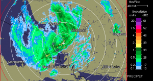
Dec 6, 2017 @ 07:51
 5:07 AM EST Wednesday 06 December 2017
Snow squall warning in effect for:
- Wawa – Pukaskwa Park
- White River – Dubreuilville
Snow squalls continue to affect areas near Lake Superior this morning.
Strong and gusty west winds to 70 km/h will frequently cause white out conditions in blowing snow, especially in exposed areas near Lake Superior.
The snow squalls are expected to drift southward out of the region beginning later this morning as winds finally veer to the northwest. This should keep additional local snowfall amounts to less than 5 centimetres early this morning.
Snow squalls cause weather conditions to vary considerably; changes from clear skies to heavy snow within just a few kilometres are common. Visibility will be suddenly reduced to near zero at times in heavy snow and blowing snow. Rapidly accumulating snow could make travel difficult over some locations. Road closures are possible.
Snow squall warnings are issued when bands of snow form that produce intense accumulating snow or near zero visibilities.
5:15 AM EST Wednesday 06 December 2017
Snow squall warning in effect for:
- Agawa – Lake Superior Park
- Searchmont – Montreal River Harbour – Batchawana Bay
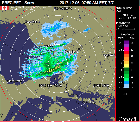
Snow squalls continue to affect areas near the eastern shores of Lake Superior this morning. Very poor visibilities have been reported due to heavy snow and blowing snow. The most intense activity continues to affect areas from north of Sault Ste. Marie to Wawa, with snow squalls occasionally reaching Highway 129 between Ranger Lake and Chapleau.
Further snowfall amounts in the heaviest snow squalls will range from near 5 cm inland to 15 cm near Lake Superior. The snow squalls will slowly drift southward out of the region this afternoon as winds veer into the northwest and diminish.
Hazardous winter driving conditions will continue today as a result.
Snow squalls cause weather conditions to vary considerably; changes from clear skies to heavy snow within just a few kilometres are common. Visibility will be suddenly reduced to near zero at times in heavy snow and blowing snow. Travel is expected to be hazardous due to reduced visibility. Road closures are possible.
Snow squall warnings are issued when bands of snow form that produce intense accumulating snow or near zero visibilities.
5:15 AM EST Wednesday 06 December 2017
Snow squall warning in effect for:
- Chapleau – Missinaibi Lake
Snow squalls continue to affect areas near the eastern shores of Lake Superior this morning. Very poor visibilities have been reported due to heavy snow and blowing snow. The most intense activity continues to affect areas from north of Sault Ste. Marie to Wawa, with snow squalls occasionally reaching Highway 129 between Ranger Lake and Chapleau.
Further snowfall amounts in the heaviest snow squalls will range from near 5 cm inland to 15 cm near Lake Superior. The snow squalls will slowly drift southward out of the region this afternoon as winds veer into the northwest and diminish.
Hazardous winter driving conditions will continue today as a result.
Snow squalls cause weather conditions to vary considerably; changes from clear skies to heavy snow within just a few kilometres are common. Visibility will be suddenly reduced to near zero at times in heavy snow and blowing snow. Travel is expected to be hazardous due to reduced visibility. Road closures are possible.
Snow squall warnings are issued when bands of snow form that produce intense accumulating snow or near zero visibilities.
Please continue to monitor alerts and forecasts issued by Environment Canada. To report severe weather, send an email to [email protected] or tweet reports using #ONStorm.

- Tuesday Morning News – July 21st - July 21, 2026
- Monday Morning News – July 20th - July 20, 2026
- Wawa FD called to Backyard Bonfire during RFZ - July 19, 2026