 Wawa-news.com Local and Regional News
Feb 21, 2017 @ 10:22
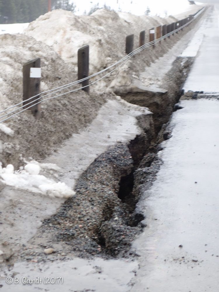
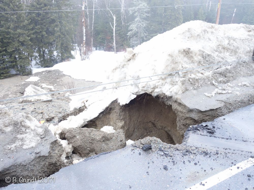
Highway 17 just north of Wawa at the Northern Lights Ford Dealership has some substantial erosion from the heavy rains last night. It appears as the water had funneled to this spot, ponded, and then broke through the snowbank, and then eroded the shoulder. It also cut a very thin crevasse between the shoulder and the pavement’s edge. It was not possible to take any photographs from the ditch side, as the embankment is very steep. That means that the total amount of damage is not visible from this angle. This is the same spot where the highway washed out during the storm of October 25th, 2012.
Rainfall gauges at Michipicoten River Village (The Mission) shows 16.8mm of rain, and the gauge at Michipicoten Harbour showed 20.6mm.
The highway will remain closed until it can be inspected for safety. There is no guess as to when the highway will reopen.
The only detour to get from White River to Wawa is via Hwy 631 to Hornepayne, to Highway 11, east to Driftwood and Hwy 655, south to Timmins, then 101 to Chapleau and then to Wawa. This is a 834-kilometre or 518-mile detour and my gps calculates it would take 11.25 hours to do.
Wawa-news.com will update its readers as information becomes available.
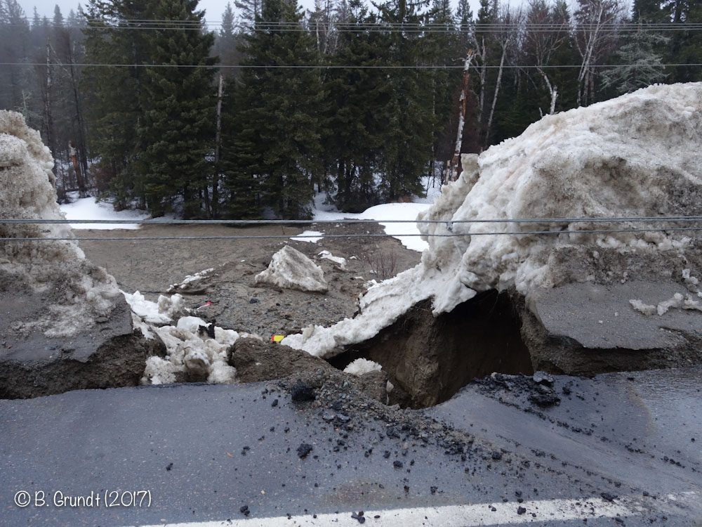
Looking south towards Wawa. The washout is on the north side of the highway.
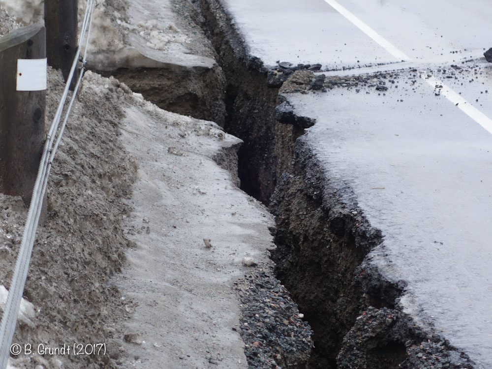
The water cut down the edge of the pavement, cutting a crevasse between the shoulder and the pavement.
One can see all the eroded material deposited at the base of the highway. It was not safe to climb down and try to get photos from the bottom.
 |
|
With permission from the Superior East OPP Wawa-news.com was able to go to the scene of the washout and take photographs at 9:30 this morning. Wawa-news would like to thank them for helping to get these images to the public.

- Friday Morning News – April 24 - April 24, 2026
- Thursday Morning News – April 23rd - April 23, 2026
- Hwy 17 (Nipigon) Open – 6:46 am - April 23, 2026
This makes me wonder if our road design and building techniques are suitable for this region.
Check out this report from the Governor General about contractors cheating out on materials for constructing our roads.
“Ms. Lysyk also found the government pays bonuses to paving companies for using higher-quality asphalt, but some of them provided high-quality samples for testing then used lower-quality asphalt on the road.”
https://www.google.ca/amp/s/sec.theglobeandmail.com/news/politics/a-g-takes-ontario-to-task-for-not-taking-contractors-to-task-over-shoddy-roadwork-construction/article33100238/%3Fservice%3Damp
Obviously they did nothing but a patch job in 2012 and did not redesign to prevent this in the future. This is a problem area that engineering needs to take a serioue look at what causes such washout at this location and fix it.
David, road design is not the problem Problem is, the land west of the highway at this spot and the buildings shouldn’t be there. This used to be a deep gulley where water that poured down into from the mountains and then drained into the lake. But, man filled in the gulley and put buildings up that try to block the run off and a highway. This worked well until the excessive rainfalls and melting snows (could this be climate change) created a need for the gulley again. The engineers need to recognize this and design proper drainage with huge culverts to handle the heavier run offs. There will be more to come.
That highway has been there since the 60’s (57 years?) and when I was a kid we got a heck of a lot more snow and the torrential downpours (for days on end!) we’re epic !!!! I have never heard about this happening in all of the years I had lived in Wawa !!!!
Daivd, I just looked at the pictures again and have to concur, this looks like the road bed wasn’t compacted enough.
My point still stands. This is going to wash out again as soon as we have heavy rain falls and heavy snow melts.
Disappointing for many after the HUGE amount of money and work that went into the last 2012 erosion at the Ford spot on Hwy 17.
They sure put in suitable culverts below (from what I saw) to replace the old ones. I am pretty sure they enlarged and and added to the culverts too. Yes, everything is cost versus benefits, but there is more expensive engineering and materials that can be completed above. Hopefully, they can do something to fix things before a massive washout occurs again.
No doubt the road closure was a given, knowing how fast water can cause massive washouts. Lots of extra miles added to a trip whether you detour and go the USA or Canada 11 routes. ? But necessary for sure.
Remember the mishappening with the newly constructed Nipigon bridge. Construction firms in that area should be familar with the challenges of building roads in a harsh weather area in Canada. I’m sure there is often a lack of accuracy with the construction habits or wrong stuff mixtures
Sand is not a good base in an area that is known to wash out.
They need to build a bridge and let the water takes it’s natural course…! Water don’t like detours!
How about upgrading the trail from Dubreuilville to Hawk Junction as a secondary road? That would back up the weak link and supply a direct route from White River to Timmins.