Wawa-news.com Local and Regional News
Dec 21, 2022 at 07:30
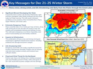
Environment Canada continues to warn of a significant winter storm for late this week and into the holiday weekend. It is expected to affect the following areas of Northern Ontario:
- City of Thunder Bay
- Superior West
- Beardmore – Jellicoe – Macdiarmid
- Geraldton – Manitouwadge – Hornepayne
- Nipigon – Marathon – Superior North
- Wawa – White River – Pukaskwa
- Sault Ste. Marie – Superior East
- Kapuskasing – Hearst
- Timmins – Cochrane
- Greater Sudbury And Vicinity
- Chapleau – Gogama
- Kirkland Lake – Temiskaming Shores – Temagami
- Elliot Lake – Ranger Lake
- Manitoulin – Blind River – Killarney.
click for larger image
The snow is expected to begin Thursday for areas near Lake Superior before reaching James Bay on Friday. Snow may become heavy at times with very strong northerly winds Friday into Saturday, with blizzard conditions are possible for areas near the northern shores of Lake Superior and downwind of Lake Nipigon.
Environment Canada has high confidence in a high-impact winter storm, the details regarding wind speeds and specific snowfall amounts remain highly uncertain at this time.
Environment Canada asks that travellers consider altering plans through the holiday weekend as travel conditions may become dangerous. Extensive utility outages are possible. Bitterly cold wind chill values are expected Friday into the weekend.
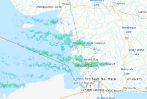 An unpredicted storm is currently affecting travel between Wawa and Batchawana Bay. Snow squalls have closed Highway 17 for 20 hours (at time of this posting).
Snow squalls are expected to continue between Wawa and Batchawana Bay this morning, ending late this morning. Additional snowfall amounts of 5 to 10 centimetres are expected.

- Tuesday Morning News – July 21st - July 21, 2026
- Monday Morning News – July 20th - July 20, 2026
- Wawa FD called to Backyard Bonfire during RFZ - July 19, 2026