Wawa-news.com Local and Regional News
Special Weather Statement for Northern Ontario, updated by Environment Canada at 4:06 p.m. EST Tuesday 20 December 2022.
———————————————————————
Special weather statement for:
- City Of Thunder Bay
Superior West
Beardmore – Jellicoe – Macdiarmid
Geraldton – Manitouwadge – Hornepayne
Nipigon – Marathon – Superior North
Wawa – White River – Pukaskwa
Sault Ste. Marie – Superior East
Kapuskasing – Hearst
Timmins – Cochrane
Greater Sudbury and Vicinity
Chapleau – Gogama
Kirkland Lake – Temiskaming Shores – Temagami
Elliot Lake – Ranger Lake
Manitoulin – Blind River – Killarney.
———————————————————————
==DISCUSSION==
Significant winter storm expected late this week into the holiday weekend.
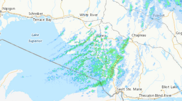
Snow is expected to begin Thursday for areas near Lake Superior before reaching James Bay on Friday. Snow may become heavy at times with very strong northerly winds Friday into Saturday. Blizzard conditions are possible for areas near the northern shores of Lake Superior and downwind of Lake Nipigon.
A multi-day lake effect snow event is expected into the weekend in the wake of the system for locations east of Lake Superior.
While there is high confidence in a high-impact winter storm, the details regarding wind speeds and specific snowfall amounts remain highly uncertain at this time. Please monitor your local forecast and the latest alerts for your area.
Consider altering plans through the holiday weekend as travel conditions may become dangerous. Extensive utility outages are possible. Bitterly cold wind chill values are expected Friday into the weekend.
Public Safety Canada encourages everyone to make an emergency plan and get an emergency kit with drinking water, food, medicine, a first-aid kit and a flashlight.
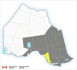
All shaded areas are included in the winter storm warning.
5:26 AM EST Tuesday 20 December 2022
Special weather statement in effect for:
- Marathon – Schreiber
- Nipigon – Rossport
- City of Thunder Bay
- Manitouwadge – Hornepayne
- Wawa – Pukaskwa Park
- White River – Dubreuilville
- Agawa – Lake Superior Park
- Searchmont – Montreal River Harbour – Batchawana Bay
- Chapleau – Missinaibi Lake
- Gogama – Foleyet…
Significant winter storm expected late this week into the holiday weekend.
Snow is expected to begin Thursday for areas near to Lake Superior before reaching James Bay on Friday. Snow may become heavy at times with very strong northerly winds Friday into Saturday. Blizzard conditions are possible for areas near the northern shores of Lake Superior and downwind of Lake Nipigon.
A multi-day lake effect snow event is expected into the weekend in the wake of the system for locations east of Lake Superior.
While there is high confidence in a high impact winter storm, the details regarding wind speeds and specific snowfall amounts remain highly uncertain at this time. Please monitor your local forecast and the latest alerts for your area.
Consider altering plans through the holiday weekend as travel conditions may become dangerous. Extensive utility outages are possible. Bitterly cold wind chill values are expected Friday into the weekend.
Public Safety Canada encourages everyone to make an emergency plan and get an emergency kit with drinking water, food, medicine, a first-aid kit and a flashlight. For information on emergency plans and kits go to http://www.getprepared.gc.ca.
Please continue to monitor alerts and forecasts issued by Environment Canada. To report severe weather, send an email to [email protected] or tweet reports using #ONStorm.
9:45 PM EST Monday 19 December 2022
Special weather statement in effect for:
- Wawa – Pukaskwa Park
- White River – Dubreuilville
- Agawa – Lake Superior Park
- Sault Ste. Marie – St. Joseph Island
- Searchmont – Montreal River Harbour – Batchawana Bay
- Chapleau – Missinaibi Lake
- Gogama – Foleyet
Significant winter storm expected late this week into the holiday weekend.
Snow is expected to begin Thursday for areas near to Lake Superior before reaching James Bay on Friday. Snow may become heavy at times with very strong northerly winds Friday into Saturday. Blizzard conditions are possible for areas near the northern shores of Lake Superior and downwind of Lake Nipigon.
A multi-day lake effect snow event is expected into the weekend in the wake of the system for locations east of Lake Superior.
While there is high confidence in a high impact winter storm, the details regarding wind speeds and specific snowfall amounts remain highly uncertain at this time. Please monitor your local forecast and the latest alerts for your area.
Consider altering plans through the holiday weekend as travel conditions may become dangerous. Extensive utility outages are possible. Bitterly cold wind chill values are expected Friday into the weekend.
Public Safety Canada encourages everyone to make an emergency plan and get an emergency kit with drinking water, food, medicine, a first-aid kit and a flashlight. For information on emergency plans and kits go to http://www.getprepared.gc.ca.
Please continue to monitor alerts and forecasts issued by Environment Canada. To report severe weather, send an email to [email protected] or tweet reports using #ONStorm.

- Monday Morning News – July 20th - July 20, 2026
- Wawa FD called to Backyard Bonfire during RFZ - July 19, 2026
- Fort Frances 14: Evacuation Order & Expanded Evacuation Alert - July 18, 2026