Wawa-news.com Local and Regional News
 |
 |
|---|
Wawa-news would like to hope that everyone has now returned home from traveling for goods in the Soo, and that all students have been able to get home from college/university. Today is not a day to be traveling. If you must be on the highways – be prepared for poor weather, road conditions and possible closures. Last night at 6 p.m. the Schreiber Fire Department tweeted, “Nobody should be attempting to drive on #Hwy17 around Lake Superior tonight. Not cars, not commercial vehicles.” It doesn’t look like things are expected to improve today.
Reports in from Manitouwade say that it is a full-on blizzard. High winds and snowing like crazy right now.
Environment Canada says, “Be prepared to adjust your driving with changing road conditions. Rapidly accumulating snow could make travel difficult over some locations. Surfaces such as highways, roads, walkways and parking lots may become difficult to navigate due to accumulating snow.”
These weather statements are not expected to interfere with Santa on his flight for Christmas Eve.
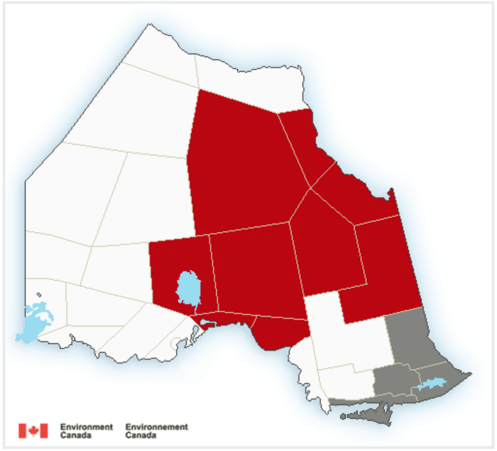
For areas in Red for Northern Ontario:
Snowfall warning in effect for:
- Wawa – Pukaskwa Park
Significant snowfall continues today. Snow will continue today. Additional snowfall up to 4 cm is expected before tapering to flurries this afternoon. Total snowfall amounts of 10 to 20 cm are expected by this afternoon. The highest snowfall amounts are expected to be north and northwest of the town of Wawa. For Wawa and areas near the shoreline of Lake Superior, snow amounts may be less than 10 cm due to a mix of wet snow and rain last night. Brisk southwesterly winds with gusts to 60 km/h are expected late this morning that may result in localized blowing snow.
- White River – Dubreuilville (ended 12:16)
Persons in or near this area should be on the lookout for adverse weather conditions and take necessary safety precautions. Watch for updated statements.
Winter storm warning in effect for:
- Marathon – Schreiber (ended 12:15)
- Nipigon – Rossport (ended 10:24 a.m.)
- Armstrong – Auden – Wabakimi Park
- Beardmore – Jellicoe – Macdiarmid
- Gull Bay – Black Sturgeon Lake
- Geraldton – Longlac – Caramat (ended 13:06)
- Manitouwadge – Hornepayne
- Nakina – Aroland – Pagwa
A significant winter storm continues this morning. Snow will continue this morning. Additional amounts up to 5 cm are possible before the snow gradually tapers to flurries from west to east by this afternoon. Total snowfall accumulations of 35 to 50 cm are expected for this storm.
Brisk northerly winds gusting 50 to 70 km/h are expected through this morning and will result in localized blowing snow over exposed areas. Hazardous winter driving conditions are expected. Motorists should consider changing travel plans accordingly.
Consider postponing non-essential travel until conditions improve. Surfaces such as highways, roads, walkways and parking lots may become difficult to navigate due to accumulating snow. Poor weather conditions may contribute to transportation delays.
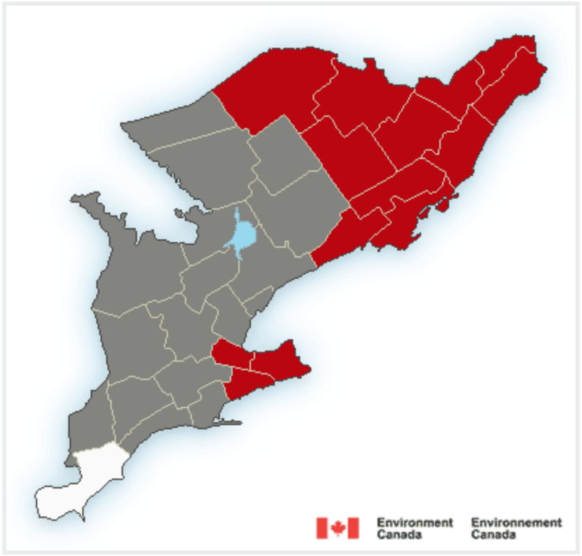
Snowfall warning in effect for:
- Fort Hope – Lansdowne House – Ogoki
- Little Abitibi – Kesagami Lake
- Attawapiskat
Significant snowfall continues early today. Snow, at times heavy, will continue this morning before gradually ending from west to east today. Total snowfall amounts of 15 to 25 cm are expected by this afternoon. Locally higher amounts in excess of 30 cm will be possible.
Brisk northerly winds gusting up to 60 km/h are also expected today and will result in localized blowing snow over exposed areas. Driving conditions will remain difficult today. Motorists should consider modifying any travel plans accordingly. Rapidly accumulating snow could make travel difficult over some locations. Visibility may be suddenly reduced at times in heavy snow.
Winter storm warning in effect for:
- Fraserdale – Pledger Lake
- Fort Albany
- Moosonee
A significant winter storm continues today. Snow, at times heavy, will continue today. Additional snowfall of 10 to 20 cm is expected before tapering to flurries tonight. Total snowfall amounts of 25 to 35 cm are expected by Friday morning.
Brisk northerly winds gusting up to 60 km/h are also expected today and will result in localized blowing snow over exposed areas. Driving conditions will remain difficult today.
Consider postponing non-essential travel until conditions improve. Surfaces such as highways, roads, walkways and parking lots may become difficult to navigate due to accumulating snow. Poor weather conditions may contribute to transportation delays.

- Strawberry Tea at the Legion today! - July 16, 2026
- Biigtigong Nishnaabeg coordinates support for Namaygoosisagagun (Collins FN) - July 16, 2026
- Air Quality remains Poor today - July 16, 2026