Wawa-news.com Local and Regional News
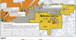
Manitou Gold Inc. has issued an exploration update on its 100% owned properties located North of Wawa, Ontario in the Michipicoten Archean Gold Camp. They are reporting that results of up to 79.9 g/t Au from outcrop grab samples were returned from the Renabie-Easy Lake Property; and that targets with highly prospective alteration and mineralization similar to that of the historic Renabie mine near Missanabie have been identified.
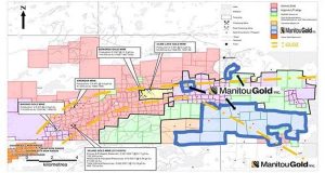
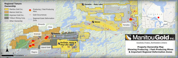
Over the past year and half, Manitou Gold Mines has accumulated 22,500 hectares of prospective gold properties, consisting of 37 kilometres of strike length with at least seven under-explored large-scale deformation zones showing favorable lithology and 50 government-documented gold occurrences.
From their media release:
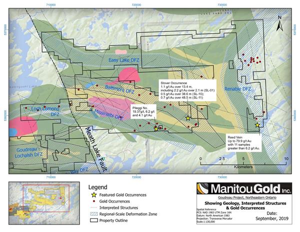
Renabie-Easy Lake Property
Examination of the area in and around the Reed Vein, located in the southeastern part of the Renabie East-Easy Lake property defined a high-strain north-northeast striking mineralized zone in tonalitic rocks of the Missinaibi Lake Batholith. Mineralization and alteration of this structure are both very similar to those of the Renabie deposit, consisting of pervasive hematite alteration and intermittent chlorite, sericite and epidote alteration and intermittent pyrite and galena mineralization. The structure has been traced for over 400 meters along surface before it disappears under overburden. It thus remains open along strike in both directions. Gold mineralization appears to occur in both foliation parallel and cross-cutting quartz veins hosted within zones of high strain.
Previous exploration in and around the Reed Vein demonstrated the presence of significant gold mineralization, but did not see any known follow-up work. Historical highlights from blasted channel samples at intervals of approximately 8 meters along the southern Reed Vein returned an average grade of 6.3 g/t Au with an average width of 1.3 m over approximately 130 m of strike length.
Surface grab sampling by MTU confirmed the presence of significant gold mineralization with assay results up to 79.9 g/t Au. A total of 18 grab samples have now been assayed from this area, with an average gold content of 18.2 g/t. Samples ranged from 79.9 to 0.1 g/t gold. An additional 13 samples from the Reed Vein are still pending analysis. Grab samples are selected samples and are not representative of the mineralization hosted on the property.
Based on current and historical results, several shallow diamond drill holes designed to test this occurrence at depth are currently being planned.
Stover Property
Ground evaluation of the Pileggi No.1 area, located in the south-central portion of the Stover property, targeted an area of known gold mineralization that has seen limited modern exploration. Historical work in the area (ca. 1940s) included trenching, numerous test pits and some limited diamond drilling. Assay results and locations of historical workings were largely undocumented.
Highlight assay results of grab samples collected in the vicinity of the old workings returned 9.37 g/t, 6.2 g/t and 4.1 g/t gold. An additional grab sample of laminated quartz collected 200 meters to south assayed 3.4 g/t gold.
Gold mineralization in the target area is associated with silicified and carbonate altered mafic volcanic rocks with laminated quartz veins and pyrite, chalcopyrite and pyrrhotite mineralization in east-southeast trending shear zones. Fieldwork completed to date in this area identified key targets for high-grade gold mineralization, which will be further evaluated by mechanical stripping to better define drill targets.
Prospecting efforts are also focusing on the Stover Lake occurrence situated in the Baltimore DFZ. An early review of a shallow 1988 drill program in the area identified wide intersections with anomalous gold values from five drill holes over a strike length of 61 meters in a predominantly quartz-sericite schist with quartz veining, pyrite mineralization and felsic dykes. The majority of holes intersected mineralization at depths of less than 100 meters.
Highlights of historical intersections at Stover include:
- 1.1 g/t Au over 13.4 m, including 2.2 g/t Au over 2.1 m with a second down-hole intersection of 0.4 g/t Au over 45.8 m (SL-01)
- 0.5 g/t Au over 38.6 m (SL-10)
- 0.7 g/t Au over 48.5 m (SL-11)
Historic drill hole intercepts disclosed above are from diamond drilling completed before the introduction of National Instrument 43-101 and results have not been verified by a Qualified Person.
The Baltimore Deformation Zone (the “BDFZ”) and the wide zones of anomalous gold mineralization it hosts are interpreted as being the continuation of the GLDZ, which hosts Alamos Gold’s Island Gold Mine. Mapping by Manitou field crews has traced the GLDZ eastwards, along strike, across the Dog Lake property. The GLDZ then appears to be offset to the North along the Meath Lake Fault, likely continuing as the Baltimore Deformation Zone for another 16 kilometers to the east-southeast across the Stover Property. Similarities between the two deformation zones include polyphase deformation and metamorphism history with two wide zones (>10s of meters) of carbonate-sericite alteration and associated silicification/quartz veining.
Rockstar
Exploration crews have been active at the Rockstar vein with surface stripping, channel sampling and trench mapping the Rockstar occurrence. Future efforts will focus on the newly discovered RS2 vein, which runs parallel and south of the Rockstar vein, to outline its size, geometry and gold potential. This vein is situated south of the GLDZ.
Strategic Partnership with Goldspot Discoveries Inc. and Target Generation
In February 2019, Manitou entered into an Investment Agreement with a related one-year services contract with Goldspot Discoveries Inc. (“Goldspot”) to assist in the data compilation, evaluation, interpretation and gold targets generation at the Company’s properties.
Since February, Goldspot has been gathering, evaluating and interpreting multiple geophysical datasets that include magnetics, EM, VTEM, TDEM, to identify structures, lithology boundaries, dykes, and iron formations in relation to the timing of the emplacement of gold mineralization. This interpretation will assist in identifying larger-scale structures, alteration features and geologic boundaries.
In parallel, ground-truthing of geology assemblages and structural timing were performed by Goldspot and Manitou’s technical teams and will be combined with geophysical interpretation for target generation. Recently, crews have been on the ground focused on the Bankfield and Rockstar occurrences with the discovery of the new RS2 gold vein with an initial grab sample of 39.3 g/t Au.
It is anticipated that by the end of September 2019, Goldspot will submit deliverables on its regional-scale geophysical evaluation for areas that cover the Baltimore, Missinaibi, Loch Lomond, Goudreau-Lochalsh, and Easy-Lake Deformation Zones.
About the Goudreau Property
Manitou Gold’s Goudreau-Renabie area properties are comprised of a 22,500-hectare land package set between Alamos Gold’s producing Island Gold mine to the West and the past producing Renabie mine to the East that traverses 37 km of contiguous lands along known deformation zones. Exploration of these properties will continue throughout the 2019-2020 field season. Grab samples are selected samples and are not representative of the mineralization hosted on the property.

- Today at LSPP – Thursday, July 30th - July 30, 2026
- Northwest Forest Fire Update – July 29 - July 30, 2026
- Northeast Forest Fire Update – July 29 - July 30, 2026