Wawa-news.com Local and Regional News
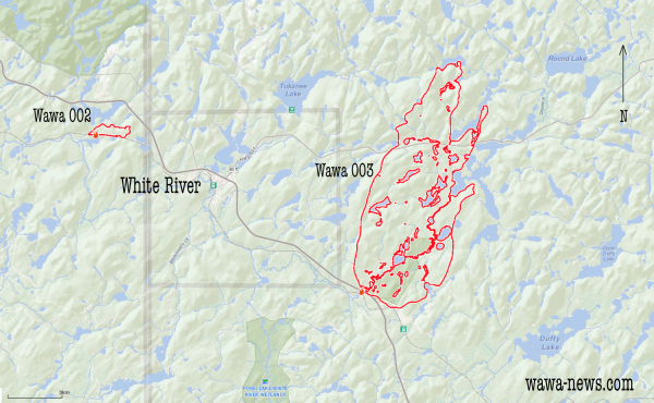
Wawa003 continues to grow with the dry weather and high temperatures. The map above shows an outline of the fire with a 3km grid overlaid. The fire has consumed an area that is just just over 12 kms long and 6km wide. It has completely burned over the Kakakiwibik Esker Conservation Reserve. It was regulated as a conservation reserve in January 2001. One thing of interest in this reserve is that several lakes have formed in the kettle troughs, which display an unusual blue-green colour that can be attributed to the presence of fine, suspended glacial sediments. Historically, there was a fire recorded that burnt this area in 1923.
| Time | Hectares | ||
| 31-May | |||
| 30-May | 18:00 | 4799.4 | |
| 29-May | 18:22 | 800 | |
| 28-May | 359 | ||
| 27-May | 18:27 | 10 | 2:36 p.m. |
The fire by virtue of the direction it is burning, has closed Highway 631 a number of times over the past couple of days. On the 29th, OPP contacted Silver Lake management requesting that they clear the site. They were advised to use the 100 road to exit. They faced a scary drive through the fire as it was burning the east side of the highway and crossing over. Some spectacular footage has been posted on social media. The Township of White River also implemented a fire ban on the 29th. A restricted fire zone has not yet been implemented by the MNRF.
The MNRF has waterbombers and heavy helicopters attacking the fire, and infrastructure is being put into place for supporting the firefighers. At this time there is a call for food service workers that are needed for the MNR Fire Camp in White River.
At this time the fire is moving north, north-northeast of White River, and does not pose a threat to the community other than poor air quality.

- Tuesday Morning News – July 28th - July 28, 2026
- Monday Morning News – July 27 - July 27, 2026
- Saturday Morning New – July 25th - July 25, 2026