Wawa-news.com Local and Regional News
Sep 21, 2022 at 06:29
 6:11 AM EDT Wednesday 21 September 2022
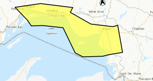
Severe thunderstorm warning in effect for:
- Chapleau – Missinaibi Lake
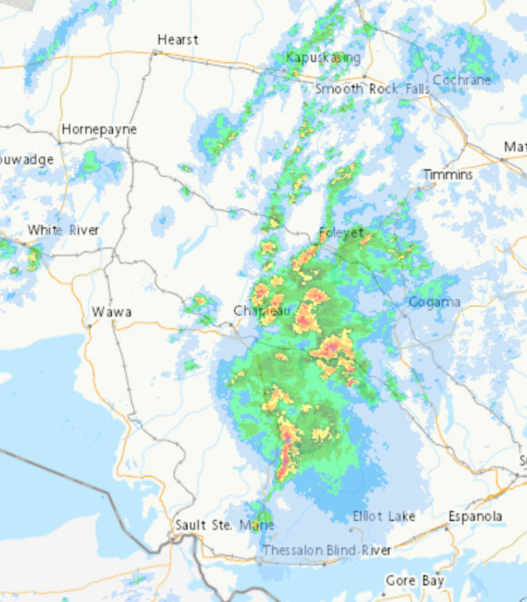
At 6:11 a.m. EDT, Environment Canada meteorologists are tracking a severe thunderstorm capable of producing very strong wind gusts and up to nickel size hail.
This line of severe thunderstorms is located from 20 kilometres north of Algoma Headwaters Provincial Park to 11 kilometres northwest of Poplar Dale, moving east at 85 km/h.
Hazard: 90 km/h wind gusts and nickel size hail.
Locations impacted include:
Algoma Headwaters Provincial Park, Ranger Lake, Aubinadong-Nushatogaini Rivers Provinci, Aubinadong River Provincial Park, Aubrey Falls Provincial Park, Wenebegon River Provincial Park, Horner Lake, Bruce Lake, Conacher Lake, Wakomata Lake, Aubrey Lake and Rocky Island Lake.
Take cover immediately, if threatening weather approaches. Large hail can damage property and cause injury. Strong wind gusts can toss loose objects, damage weak buildings, break branches off trees and overturn large vehicles. If visibility is reduced while driving, slow down, watch for tail lights ahead and be prepared to stop. Intense lightning is likely with any thunderstorm that develops. Avoid areas of the building that could be affected by falling debris such as tree limbs. Lightning kills and injures Canadians every year. Remember, when thunder roars, go indoors!
Severe thunderstorm warnings are issued when imminent or occurring thunderstorms are likely to produce or are producing one or more of the following: large hail, damaging winds, torrential rainfall.
The Office of the Fire Marshal and Emergency Management recommends that you take cover immediately if threatening weather approaches.
Please continue to monitor alerts and forecasts issued by Environment Canada. To report severe weather, send an email to [email protected] or tweet reports using #ONStorm.
Sep 21, 2022 at 05:30
Weather Radar at 5:20 a.m.
4:23 AM EDT Wednesday 21 September 2022
Severe thunderstorm watch in effect for:
- Chapleau – Missinaibi Lake
- Gogama – Foleyet
Conditions are favourable for the development of dangerous thunderstorms that may be capable of producing damaging wind gusts and damaging hail.
Hazards:
90 km/h wind gusts.
Up to toonie size hail.
Timing:
This morning.
Very large hail can damage property, break windows, dent vehicles and cause serious injury. Very strong wind gusts can damage buildings, down trees and blow large vehicles off the road. Intense lightning is likely with any thunderstorm that develops. Be prepared for severe weather. Take cover immediately, if threatening weather approaches. Stay indoors when a thunderstorm strikes. There isn’t a place outside that is safe during a thunderstorm. Lightning kills and injures Canadians every year. Remember, when thunder roars, go indoors!
Severe thunderstorm watches are issued when atmospheric conditions are favourable for the development of thunderstorms that could produce one or more of the following: large hail, damaging winds, torrential rainfall.
The Office of the Fire Marshal and Emergency Management recommends that you take cover immediately if threatening weather approaches.
Please continue to monitor alerts and forecasts issued by Environment Canada. To report severe weather, send an email to [email protected] or tweet reports using #ONStorm.
Orange Alert = Severe weather
Red Alert = Very dangerous and possibly life-threatening weather
For road conditions and other traveller information from the Ministry of Transportation, visit https://www.ontario.ca/511, or call 5-1-1.
Please continue to monitor alerts and forecasts issued by Environment Canada. To report severe weather, send an email to [email protected] or tweet reports using #ONStorm.
- Yellow Fog Advisory (Nipigon – Rossport) ENDED - July 26, 2026
- Yellow Fog Advisory (Marathon – Schreiber) ENDED - July 26, 2026
- Yellow Fog Advisory (Agawa – Lake Superior Park) ENDED - July 26, 2026