Wawa-news.com Local and Regional News
Nov 22, 2021 at 05:16
5:01 AM EST Monday 22 November 2021
Weather advisory ended for:
- Gogama – Foleyet
5:00 AM EST Monday 22 November 2021
Weather advisory ended for:
- Chapleau – Missinaibi Lake
Nov 21, 2021 at 23:15
10:27 PM EST Sunday 21 November 2021
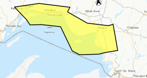
Weather advisory in effect for:
- Chapleau – Missinaibi Lake
Winter weather travel advisory in effect.
Messy winter weather expected tonight into Monday as a strong cold front races through.
A mix of wet snow and rain will change over to snow or flurries in the wake of the cold front this evening. There could also be a narrow band of intense snow associated with the cold front that could allow for rapidly accumulating snowfall tonight along with reduced visibilities at times.
Behind the cold front, temperatures are also expected to plunge below the freezing mark possibly leading to icy roads and sidewalks.
Snowfall amounts of 5 to 10 cm are expected by Monday morning.
Motorists should expect hazardous winter driving conditions and adjust travel plans accordingly. Travel may be hazardous due to sudden changes in the weather. Prepare for quickly changing and deteriorating travel conditions. If visibility is reduced while driving, slow down, watch for tail lights ahead and be prepared to stop.
Nov 21, 2021 at 21:45
9:33 PM EST Sunday 21 November 2021
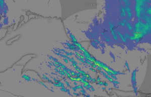
Image from windy.com
Weather advisory in effect for:
- Gogama – Foleyet
Winter weather travel advisory in effect.
Messy winter weather tonight into Monday as a strong cold front races through.
A mix of wet snow and rain will change over to snow or flurries in the wake of the cold front tonight. Strong northwesterly winds behind the front will accompany the snow resulting in blowing snow, which could reduce visibilities at times.
Additionally, temperatures are expected to plunge below the freezing mark behind the cold front tonight possibly leading to icy roads and sidewalks.
Snowfall amounts of 5 to 10 cm are expected by Monday afternoon, A few local amounts of 10 to 15 cm are possible.
Motorists should expect hazardous winter driving conditions and adjust travel plans accordingly. If visibility is reduced while driving, slow down, watch for tail lights ahead and be prepared to stop. Visibility may be suddenly reduced at times in heavy snow.
[breaker]4:05 PM EST Sunday 21 November 2021
Weather advisory in effect for:
- Chapleau – Missinaibi Lake
Winter weather travel advisory in effect.
Messy winter weather is expected tonight into Monday as a strong, cold front races through.
A mix of wet snow and rain will change over to snow or flurries in the wake of the cold front this evening. There could also be a narrow band of intense snow associated with the cold front that could allow for rapidly accumulating snowfall tonight along with reduced visibilities at times.
Behind the cold front, temperatures are also expected to plunge below the freezing mark possibly leading to icy roads and sidewalks.
Snowfall amounts of 5 to 10 cm are expected by Monday morning.
Motorists should expect hazardous winter driving conditions and adjust travel plans accordingly. Travel may be hazardous due to sudden changes in the weather. Prepare for quickly changing and deteriorating travel conditions. If visibility is reduced while driving, slow down, watch for tail lights ahead and be prepared to stop.
Orange Alert = Severe weather
Red Alert = Very dangerous and possibly life-threatening weather
For road conditions and other traveller information from the Ministry of Transportation, visit https://www.ontario.ca/511, or call 5-1-1.
Please continue to monitor alerts and forecasts issued by Environment Canada. To report severe weather, send an email to [email protected] or tweet reports using #ONStorm.
- Yellow Fog Advisory (Nipigon – Rossport) ENDED - July 26, 2026
- Yellow Fog Advisory (Marathon – Schreiber) ENDED - July 26, 2026
- Yellow Fog Advisory (Agawa – Lake Superior Park) ENDED - July 26, 2026