Wawa-news.com Local and Regional News
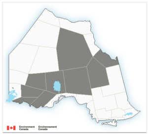
Areas in grey are affected by this special weather statement.
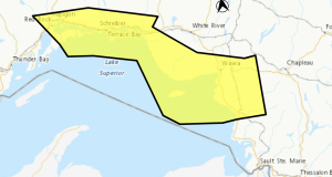
At 5:25 a.m. Environment Canada issued a Special Weather Statement warning of snow for regions of Ontario including Manitouwadge – Hornepayne.
A low-pressure system originating from the Four Corners (Utah, Arizona, Colorado, New Mexico)) is expected to impact the region tonight into Wednesday night.
Precipitation associated with the low may begin as rain or a mix of rain and snow tonight but is expected to transition over to just snow by early Wednesday morning bringing snowfall accumulations in the amounts of 10 to 25 cm possible. Winds are expected to increase out of the northeast on Wednesday which will lead to locally blowing snow and reduced visibility in exposed areas. While flash freeze conditions are not expected at this time, the northerly winds will usher in a significantly cooler air mass which could lead to some icy conditions Wednesday morning.
The snow and winds are expected to taper off from southwest to northeast Wednesday evening into Wednesday night. Total snowfall amounts of 10 to 25 cm are expected by Wednesday night. Some regions may need to be upgraded to a snowfall warning as the event draws nearer.

- Saturday Morning New – July 25th - July 25, 2026
- Friday Morning New – July 24th - July 24, 2026
- Thursday Morning New – July 23rd - July 23, 2026