Wawa-news.com Local and Regional News
Manitou Gold Inc. is pleased to announce high-grade assay results from two diamond drill holes at the recently discovered Bald Eagle gold zone at its 100% owned Goudreau project in northern Ontario.
Highlights:
- All six drill holes at the BEGZ intersected significant gold mineralization, including the most recent two step-out holes drilled 100 m east-southeast of previously announced drill holes.
- New intersections include:
- 19.7 g/t Au over 1.0 m, 7.1 g/t Au over 1.0 m and 6.3 g/t Au over 1.0 m in hole MTU-21-44; and
- 10.9 g/t Au over 0.7 m in hole MTU-21-43
- Second drill to be mobilized to the property in the coming days for follow-up drilling at the new BEGZ discovery
The Company has now received additional results for two step-out holes drilled 100 m east-southeast of previously reported drill holes. Highlights of the two holes include 19.7 g/t Au over 1.0 m, 7.1 g/t Au over 1.0 m and 6.3 g/t Au over 1.0 m in hole MTU-21-44 and 10.9 g/t Au over 0.7 m in hole MTU-21-43.
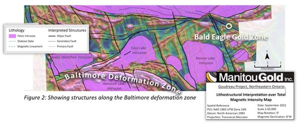
On September 28, 2021, the Company announced results of its first four drill holes at the BEGZ, located approximately six kilometers northeast of the BDZ grid. As previously reported, highlights of the first four drill holes at the BEGZ included 3.3 g/t Au over 3.0 m, including 5.2 g/t Au over 1.5 m within wider gold mineralized interval of 20.6 m grading 0.8 g/t Au in hole MTU-21-41, and
1.4 g/t Au over 9.0 m and 2.8 g/t Au over 1.4 m within a wider gold mineralized interval of 22.8 m at 0.9 g/t Au in hole MTU-21-39.
Following these highly encouraging drill results, a second drill has been contracted and will be mobilized to the property in the coming days for follow-up drilling at the new BEGZ discovery while the original drill is continuing to test high priority targets along a 10 km long section of the Baltimore deformation zone (“BDZ”).
Table 1: Highlight Drill Intersections
| Hole ID | From | To | Core Length1 (m) |
Au (g/t) |
Zone | ||
| MTU-21-43 | 24.8 | 25.5 | 0.7 | 10.9 | Bald Eagle Gold Zone | ||
| 61 | 62.3 | 1.3 | 1.9 | Bald Eagle Gold Zone | |||
| MTU-21-44 | 19 | 20 | 1.0 | 7.1 | Bald Eagle Gold Zone | ||
| 23.5 | 26 | 2.5 | 8.2 | Bald Eagle Gold Zone | |||
| incl. | 25 | 26 | 1.0 | 19.7 | Bald Eagle Gold Zone | ||
| 253.6 | 254.6 | 1.0 | 6.3 | Bald Eagle Gold Zone | |||
| Previously Reported | |||||||
| MTU-21-39 | 48.0 | 49.5 | 1.5 | 2.8 | Bald Eagle Gold Zone | ||
| 181.9 | 183.0 | 1.1 | 1.6 | Bald Eagle Gold Zone | |||
| 216.0 | 238.8 | 22.8 | 0.9 | Bald Eagle Gold Zone | |||
| incl. | 217.0 | 226.0 | 9.0 | 1.4 | Bald Eagle Gold Zone | ||
| incl. | 224.5 | 226.0 | 1.5 | 2.8 | Bald Eagle Gold Zone | ||
| MTU-21-40 | 75.5 | 77.0 | 1.5 | 1.1 | Bald Eagle Gold Zone | ||
| 116.9 | 121.5 | 4.6 | 0.9 | Bald Eagle Gold Zone | |||
| incl. | 120.0 | 121.5 | 1.5 | 1.3 | Bald Eagle Gold Zone | ||
| 177.0 | 179.0 | 2.0 | 1.7 | Bald Eagle Gold Zone | |||
| 198.0 | 202.5 | 4.5 | 0.8 | Bald Eagle Gold Zone | |||
| 208.5 | 227.0 | 18.5 | 0.5 | Bald Eagle Gold Zone | |||
| incl. | 210.0 | 211.5 | 1.5 | 1.3 | Bald Eagle Gold Zone | ||
| MTU-21-41 | 46.5 | 49.5 | 3.0 | 1.0 | Bald Eagle Gold Zone | ||
| incl. | 46.5 | 48.0 | 1.5 | 1.5 | Bald Eagle Gold Zone | ||
| 122.0 | 123.0 | 1.0 | 2.5 | Bald Eagle Gold Zone | |||
| 126.2 | 127.0 | 0.8 | 1.8 | Bald Eagle Gold Zone | |||
| 197.5 | 218.1 | 20.6 | 0.8 | Bald Eagle Gold Zone | |||
| incl. | 209.5 | 212.5 | 3.0 | 3.3 | Bald Eagle Gold Zone | ||
| incl. | 209.5 | 211.0 | 1.5 | 5.1 | Bald Eagle Gold Zone | ||
| MTU-21-42 | 78.7 | 80.0 | 1.3 | 2.4 | Bald Eagle Gold Zone | ||
| 144.0 | 145.5 | 1.5 | 1.8 | Bald Eagle Gold Zone | |||
| 155.5 | 156.5 | 1.0 | 1.4 | Bald Eagle Gold Zone | |||
(1)Lengths are reported as core lengths. True thickness of the newly announced intersections have yet to be determined but are typically estimated at 85% of reported intervals based on observed core angles.
Drilling is currently testing new priority targets along the BDZ, including coincident multi-line gold +/- copper soil geochemistry anomalies with strike lengths of up to 350 m and coincident IP anomalies in close proximity to prominent structural intersections. The BDZ represents the interpreted fault offset continuation of the Goudreau-Localsh Deformation Zone (the “GLDZ”), which makes it a highly prospective regional exploration area, given known economic mineral resources located within the GLDZ. The GDLZ hosts Alamos Gold’s Island gold deposit and Argonaut Gold’s Magino deposit, in addition to a number of smaller-scale past-producing mines, including the past-producing Cline and Edwards mines.
About the Goudreau Project
The Goudreau project is located 50 kilometres northeast of Wawa, Ontario and is underlain by Archean-aged rocks of the Michipicoten greenstone belt. The project area is traversed by several broad-scale deformation corridors (such as the BDZ and GLDZ), which host the majority of the important regional gold deposits and showings in the region.
The BDZ is interpreted as an eastward trending fault offset extension of the GLDZ, the latter of which hosts two multi-million ounce gold deposits (1,2) and has seen over 1,000,000 metres of drilling for gold. As such, the BDZ is extremely under-explored along its 18 kilometre-long trend, with only 4,400 metres of historic gold drilling.
The Goudreau project covers approximately 350 square kilometres in this re-emerging gold camp that hosts several multi-million ounce gold deposits (1,2).
Manitou’s key strategic shareholders include Alamos Gold Inc. (TSX:AGI; NYSE:AGI) at 19.9% and O3 Mining Inc. (TSX.V: OIII; OTCQX: OIIIF) at 9.9%, each individually calculated on a partially diluted basis.

- First Nation Leaders to Hold Press Conference to Address Ontario’s Wildfire Response - July 21, 2026
- Northwestern Ontario Community Support Fund Established - July 21, 2026
- Men’s Night Golf – Results of July 16th - July 21, 2026