Wawa-news.com Local and Regional News
Severe thunderstorm warning in effect for:
- Geraldton – Longlac – Caramat
- Manitouwadge – Hornepayne
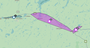
At 11:23 a.m. EDT, Environment Canada meteorologists are tracking a severe thunderstorm capable of producing very strong wind gusts and up to nickel size hail.
This line of severe thunderstorms is approximately located from Sagiwatan Lake to 10 kilometres south of Solann Lake, moving east at 65 km/h.
Hazards: 90 km/h wind gusts and nickel size hail.
Source: Radar indicated.
Locations impacted include:
Manitouwadge, Waboosekon Lake, Stevens and Hillsport.
Take cover immediately, if threatening weather approaches. Large hail can damage property and cause injury. Strong wind gusts can toss loose objects, damage weak buildings, break branches off trees and overturn large vehicles. Locally heavy rain is also possible. Intense lightning is likely with any thunderstorm that develops. Lightning kills and injures Canadians every year. Remember, when thunder roars, go indoors!
Severe thunderstorm warnings are issued when imminent or occurring thunderstorms are likely to produce or are producing one or more of the following: large hail, damaging winds, torrential rainfall.
Severe thunderstorm watch in effect for:
- Manitouwadge – Hornepayne
- Nakina – Aroland – Pagwa
Conditions are favourable for the development of severe thunderstorms that may be capable of producing strong wind gusts and large hail.
Hazards:
Hail to 2 cm in diameter
Damaging wind gusts to 90 km/h
Where:
Northeastern Ontario including Kapuskasing, Hearst and Nagagami
When:
Early this afternoon until early evening.
Discussion:
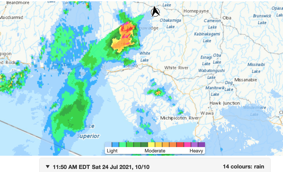
Thunderstorms near and north of Lake Superior are expected to intensify as they move eastward today. There will be a risk of damaging wind gusts to 90 km/h as well as 2 cm hail. The risk will end from west to east today with the passage of a cold front.
Large hail can damage property and cause injury. Strong wind gusts can toss loose objects, damage weak buildings, break branches off trees and overturn large vehicles. Lightning kills and injures Canadians every year. Remember, when thunder roars, go indoors!
Severe thunderstorm watches are issued when atmospheric conditions are favourable for the development of thunderstorms that could produce one or more of the following: large hail, damaging winds, torrential rainfall.
Severe thunderstorm watch in effect for:
- Chapleau – Missinaibi Lake
Conditions are favourable for the development of severe thunderstorms that may be capable of producing strong wind gusts and large hail.
Hazards:
Hail to 2 cm in diameter
Damaging wind gusts to 90 km/h
Where:
Northeastern Ontario including Kapuskasing, Hearst and Nagagami
When:
Early this afternoon until early evening.
Discussion:
Thunderstorms near and north of Lake Superior are expected to intensify as they move eastward today. There will be a risk of damaging wind gusts to 90 km/h as well as 2 cm hail. The risk will end from west to east today with the passage of a cold front.
Large hail can damage property and cause injury. Strong wind gusts can toss loose objects, damage weak buildings, break branches off trees and overturn large vehicles. Lightning kills and injures Canadians every year. Remember, when thunder roars, go indoors!
Severe thunderstorm watches are issued when atmospheric conditions are favourable for the development of thunderstorms that could produce one or more of the following: large hail, damaging winds, torrential rainfall.

- Today at LSPP – Wednesday, July 29th - July 29, 2026
- Northwest Forest Fire Update – July 28 - July 29, 2026
- Northeast Forest Fire Update – July 28 - July 29, 2026