 Wawa-news.com Local and Regional News
At 7 p.m. the Special Weather Statements were cancelled.
Jun 10, 2020 at 14:39 – 1:07 PM EDT Wednesday 10 June 2020
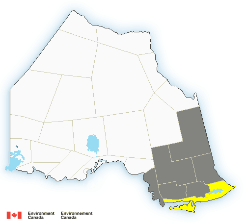 Special weather statement in effect for (grey areas):
- Agawa – Lake Superior Park
- Sault Ste. Marie – St. Joseph Island
- Searchmont – Montreal River Harbour – Batchawana Bay
Wind gusts to 80 km/h possible this afternoon.
A strong area of low pressure is traversing Northeastern Ontario this afternoon. Winds gusting 70 to 80 km/h are likely this afternoon before tapering by early this evening. A few areas may experience local power outages.
1:33 PM EDT Wednesday 10 June 2020
Severe thunderstorm watch in effect for (yellow areas):
- Blind River – Thessalon
- Espanola – Killarney
- Manitoulin Island
Conditions are favourable for the development of dangerous thunderstorms that may be capable of producing damaging wind gusts and heavy rain.
A line of severe thunderstorms over Central Lower Michigan may reach the area between 3 and 4 PM this afternoon.
Wind gusts of 100 km/h from the thunderstorms, and torrential downpours are possible.
The very strong winds may result in power outages.
Very strong wind gusts can damage buildings, down trees and blow large vehicles off the road. Heavy downpours are likely to cause flash floods and water pooling on roads. Lightning kills and injures Canadians every year. Remember, when thunder roars, go indoors!
Severe thunderstorm watches are issued when atmospheric conditions are favourable for the development of thunderstorms that could produce one or more of the following: large hail, damaging winds, torrential rainfall.
The Office of the Fire Marshal and Emergency Management recommends that you take cover immediately if threatening weather approaches.

- Goulais Fire – Total Fire Ban in Effect - July 16, 2026
- LDHC – 75th Anniversary Celebrations - July 16, 2026
- Township of Gillies – State of Emergency - July 16, 2026