Wawa-news.com Local and Regional News
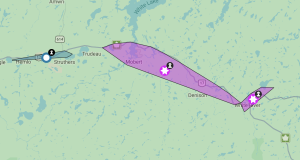
12:09 PM EDT Wednesday 18 March 2020
Special weather statement in effect for:
- Wawa – Pukaskwa Park
- White River – Dubreuilville
- Marathon – Schreiber
- Nipigon – Rossport
- Geraldton – Longlac – Caramat
- Manitouwadge – Hornepayne
- Nakina – Aroland – Pagwa
- Beardmore – Jellicoe – Macdiarmid
Significant snowfall expected Thursday into Thursday night.
An approaching low pressure system will track over Lake Huron late Thursday bringing snow to Northern Ontario. Snow will begin over the north shore of Lake Superior tonight and become heavier through the day Thursday. Snow will continue Thursday evening before gradually weakening Thursday night or Friday morning.
Total snowfall amounts of 10 to 20 cm are expected.
There remains some uncertainty in the track of the low pressure system and the northern extent of the heavy snow. Snowfall warnings may be required as the situation becomes more clear.
Motorists are advised to prepare for difficult travel conditions Thursday and Thursday night.
11:30 AM EDT Wednesday 18 March 2020
Winter storm watch in effect for:
- Fraserdale – Pledger Lake
- Kapuskasing – Hearst – Smooth Rock Falls
- Little Abitibi – Kesagami Lake
Snow and blowing snow expected Thursday evening into Friday.
An approaching low pressure system will track over Lake Huron late Thursday bringing snow to Northern Ontario. Snow will begin over the area overnight and become heavier on Thursday. Snow will gradually weaken Friday afternoon.
Total snowfall amounts of 15 to 25 cm are expected.
Additionally, northerly winds gusting 50 or 60 km/h are expected Friday resulting in blowing snow.
There remains some uncertainty in the exact track of this low and the northern extent of the highest snowfall amounts. Winter Storm Warnings may be required as the situation becomes more clear.
Rapidly accumulating snow could make travel difficult over some locations. Visibility may be suddenly reduced at times in heavy snow.

- Today at LSPP – Wednesday, July 29th - July 29, 2026
- Northwest Forest Fire Update – July 28 - July 29, 2026
- Northeast Forest Fire Update – July 28 - July 29, 2026