Wawa-news.com Local and Regional News
Oct 26, 2017 @ 08:01
Red Pine Exploration Inc. announces three exploration targets in connection with its Wawa Gold Project, located 2 km southeast of Wawa, Ontario. The Exploration Targets were identified and interpreted by Brian Thomas, P. Geo. of Golder Associates Ltd. (“Golder”), independent of the issuer within the meaning of section 1.5 of the National Instrument 43-101.
Highlights:
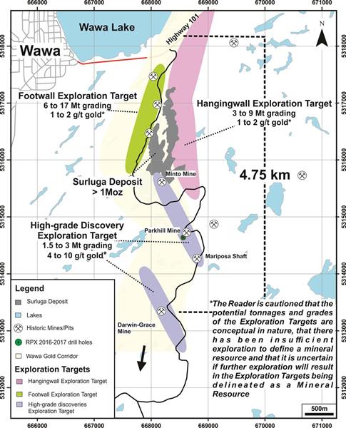
• Summary of Exploration Targets (Figure 1):
- Hangingwall Exploration Target ranging from 3 Mt to 9 Mt at 1 g/t to 2 g/t
- Footwall Exploration Target ranging from 6 Mt to 17 Mt at 1 g/t to 2 g/t
- High-Grade Discovery Exploration Target ranging from 1.5 Mt to 3 Mt at 4 g/t to 10 g/t
- Contained ounces in the combined three Exploration Targets ranging from 0.5 M oz to 2.5 M oz.
- The Reader is cautioned that the potential tonnages and grades of the Exploration Targets are conceptual in nature, that there has been insufficient exploration to define a mineral resource and that it is uncertain if further exploration will result in any of the Exploration Targets being delineated as a mineral resource;
• Exploration Targets are part of a coherent system – supports the possibility that the Wawa Gold Corridor is a large gold system;
• Exploration Targets demonstrate, conditional on successful exploration, the potential for upside of the property;
• All of the Exploration Targets remain un-tested along strike and down-dip.
Quentin Yarie, President and CEO of Red Pine, stated, “As all the Exploration Targets are constrained to drilled areas, large potential for expansion remains along strike and down-dip for all the target areas of the mineralized structures. The Company’s current exploration has been positively demonstrating the continuity of these structures – especially along the Minto Mine South Zone. Our future drilling programs will focus on converting the Exploration Targets into Inferred Mineral Resources, and expanding our exploration into the un-explored areas of these structures.”
The Exploration Targets demonstrate the size potential of the project, above the current existing inferred resource of 1,088,000 oz gold at an average grade of 1.71 g/t contained within 19.82 million tonnes1.
Red Pine Completes Over 25,000m of drilling to date in 2017 – Advancing from Exploration to Delineation
To better evaluate the potential of the Wawa Gold Corridor and to optimize its on-going exploration program, the Company tasked Golder to provide guidance to identify the Exploration Targets.
A number of individual zones have been identified based on assay results, structural and lithological relationships such as alteration and gold content. For each of the individual gold zones in each Exploration Target, Golder ranked the exploration potential of each zone using a numbering system of 1 through 5 – with 5 representing the highest potential.
| Table 2: Individual gold zones currently identified within the conceptual Exploration Targets |
||
| Conceptual Exploration Target | Individual Gold Zone | Priority based on Golder Associates Guidance |
| Hangingwall | Jasper Vein | 2 |
| Algoma North | 2 | |
| Algoma Zone | 4 | |
| Algoma Low | 2 | |
| Algoma Low 1 | 2 | |
| Algoma South | 3 | |
| Minto B | 5 | |
| Footwall | Surluga Road | 5 |
| Surluga Road South | 3 | |
| L7 Gold Zone | 2 | |
| Hornblende Upper | 5 | |
| Hornblende Lower | 5 | |
| William Gold Zone | 3 | |
| William Lower | 3 | |
| High-Grade Discovery | Minto Mine South Zone | 5 |
| Grace Deformation | 4 | |
Wawa Gold Corridor
 Since its involvement with the Wawa Gold Project, commencing in December 2014, Red Pine has demonstrated that the Jubilee Shear Zone, which hosts all of the inferred resource as identified in the Company’s technical report, is part of a larger deformation and gold mineralization corridor named the Wawa Gold Corridor.
The Wawa Gold Corridor consists of a network of interconnected gold-bearing shear and replacement zones extending for at least 8 km northerly by 0.5 km easterly. Individual shear zones range from 0.5 m to 100 m thick. Gold mineralization is also hosted in large replacement zones measuring up to 20 m thick. The southern, western and eastern boundaries of the Wawa Gold Corridor remain unknown.
Construction of the solids used to provide guidance on continued drilling campaign.
The geological solids used for the individual gold zones were constructed in Leapfrog Geo from drill hole and assay data compiled by Red Pine as well as historic drill holes from the previous operators of the property. For instances where historic holes were unsampled, the boundaries of the structures were defined using the descriptions available in the drill logs. Please see the Technical Report for further information. The geometry of the solids was further constrained using structural measurements obtained by Red Pine oriented drilling, surface structural measurements and grade distributions within recent and historic drill holes. Red Pine provided Golder with the solids used for the reporting of the Exploration Targets. This data was used both for the interpretation of the Exploration Targets and to provide Red Pine with an assessment of the level of effort to advance these zones to a NI 43-101 resource status.
Gold Zone determination
The gold bearing zones are based on declustered sample data and conceptual mineral envelopes provided by Red Pine as determined from ongoing exploration as previously described.
Golder Associates completed a site visit to the Surluga property between May 15 and 16, 2017. During the site visit all geological logging, sampling and quality assurance and quality control (QA/QC) procedures were reviewed, drill hole collar locations were verified by handheld GPS, surface trenches were visited, and 17 verification samples were taken from quarter sawn, HQ- and NQ-sized drill core. Golder determined that all procedures used by Red Pine were found to be consistent with industry standard practices.
Golder recommends to continue the exploration effort to improve the geological understanding and increase the level of confidence in the geometry and distribution of gold in the conceptual Exploration Targets. However, the reader is cautioned that the potential tonnages and grades of the Exploration Targets disclosed above are conceptual in nature, that there has been insufficient exploration to define a mineral resource and that it is uncertain if further exploration will result in any of the Exploration Targets being delineated as a mineral resource.
Background
The Wawa Gold property package consists of over 5,500 hectares and hosts several former mines with a combined historic production of 120,000 oz. gold2. To date, the largest gold deposit on the property is the Surluga Deposit, which hosts a NI 43-101 Inferred Resource of 1,088,000 oz. gold at an average grade of 1.71 g/t (using a 0.5 g/t cut-off) contained within 19.82 million tonnes1.
Since December 2014, Red Pine’s exploration work has involved the ongoing sampling of 42,000 m of historic core that was never sampled by previous operators of the project, and aggressive drilling campaigns. To date, the Company has completed over 25,000 m of drilling and made four discoveries along the extension of the Surluga Deposit: the Surluga North Zone; the Hornblende-William Zone; the Minto Mine South Zone and; the Grace-Darwin Zone. These are part of the Wawa Gold Corridor, a gold-mineralization zone that extends for more than 5 km.
Red Pine’s completed 25,000 m drill program is designed to potentially expand the size of the existing inferred gold resource and connect the other zones of gold mineralization along the newly-discovered Wawa Gold Corridor. Two drills are currently operating non-stop- one is targeting the Surluga North discovery (14.66 g/t gold over 15.23 m (SD-16-45)) while the second drill is targeting the Minto Mine South Zone discovery (19.92 g/t gold over 3 m (SD-17-73)). However, there has been insufficient exploration to define any additional mineral resource above what is identified in the Technical Report and that it is uncertain if further exploration will result in any of the Exploration Targets being delineated as a mineral resource.
1NI 43-101 inferred resource of 1,088,000 ounces of gold at 1.71 grams per tonne (g/t) using a 0.40 g/t gold cut-off grade for pit-constrained and 2.50 g/t gold cut-off grade for underground-constrained resources, contained in 19.82 million tonnes open along strike and at depth. The Cut-off grades are based on a gold price of US$1,250 per once and a gold recovery of 95 percent (Mineral Resource Statement, Surluga-Jubilee Gold Deposit, Wawa Gold Project, Ontario, SRK Consulting (Canada) Inc. (effective May 26, 2015)).
2Mineral Resource Statement, Surluga-Jubilee Gold Deposit, Wawa Gold Project, Ontario, SRK Consulting (Canada) Inc. (effective May 26, 2015)). The report is available on www.SEDAR.com under Red Pine’s profile.

- Today at LSPP – Monday, August 3rd - August 3, 2026
- NW Forest Fire Region Update – August 2 - August 3, 2026
- NE Forest Fire Region Update – August 2 - August 3, 2026