an 21, 2026 at 07:23
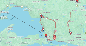
Yellow Warning – Snow Squall
Impact Level: Moderate
Forecast Confidence: Very High
Lake effect snow continues.
What:
- Snowfall accumulations of 30 to 50 cm.
- Significantly reduced visibility in heavy snow and local blowing snow.
When: Continuing through the day, and possibly into Thursday for locations south of Lake Superior Provincial Park.
Additional information: Lake effect snow will continue to impact the region today. Winds are expected to become more northwesterly on Thursday which will push the lake effect snow southward.
Travel will be hazardous. Visibility will be suddenly reduced to near zero at times. Roads and walkways will be difficult to navigate due to accumulating snow. Road closures are possible. Prepare for quickly changing and deteriorating travel conditions. Consider postponing non-essential travel and outdoor activities until conditions improve.
Jan 20, 2026 at 07:13
Yellow Warning – Snow Squall
Impact Level: Moderate
Forecast Confidence: High
Lake effect snow continues.
What:
- Snowfall accumulations of 20 to 40 cm.
- Significantly reduced visibility in heavy snow and local blowing snow.
When: Continuing through this afternoon for areas from Batchawana Bay and south. This through Wednesday, and possibly into Thursday for locations north of Batchawana Bay to Lake Superior Provincial Park.
Additional information: Lake effect snow will lift north through the day as winds become westerly. Westerly winds gusting up to 50 km/h near Lake Superior will result in local blowing snow on today.
Travel will likely be hazardous. Visibility will likely be suddenly reduced to near zero at times. Roads and walkways will likely be difficult to navigate due to accumulating snow. Prepare for quickly changing and deteriorating travel conditions.
Jan 19, 2026 at 11:13
Yellow Watch – Snow Squall
Impact Level: Moderate
Forecast Confidence: High
Lake effect snow off Lake Superior expected.
What:
- Snowfall accumulations of 15 to 30 cm.
- The highest amounts are most likely near to Lake Superior.
- Significantly reduced visibility in heavy snow and local blowing snow.
When: This evening to Tuesday afternoon for Sault Ste. Marie to Batchawana Bay. Tuesday morning through Wednesday for locations north of Batchawana Bay to Lake Superior Provincial Park.
Additional information: Lake effect snow may move into the area from the Upper Peninsula of Michigan this evening. The lake effect snow should lift north of Sault Ste. Marie Tuesday afternoon as winds become westerly.
Lake effect snow may continue to affect areas east of Lake Superior through Wednesday. Westerly winds gusting up to 50 km/h near Lake Superior will result in local blowing snow on Tuesday.
Travel may be hazardous. Visibility may be suddenly reduced to near zero at times. Roads and walkways may be difficult to navigate due to accumulating snow. Prepare for the possibility of quickly changing and deteriorating travel conditions.
- Major winter storm expected Sunday (Montreal River Harbour – Searchmont) - March 14, 2026
- Major winter storm expected Sunday (Sault Ste. Marie – St. Joseph Island) - March 14, 2026
- Major winter storm expected Sunday (Gogama – Foleyet) - March 14, 2026
 Wawa-news.com Local and Regional News

