 Wawa-news.com Local and Regional News
Jan 8, 2026 at 06:56
Special Weather Statement (grey)
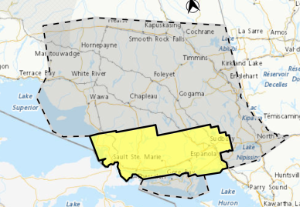
The grey area is the ‘wintry mix’, and the yellow is under a rainfall alert.
A wintry mix expected tonight through Friday.
What:
- Total rainfall amounts of 5 to 10 mm.
- Total snowfall amounts of 10 to 15 cm.
- Reduced visibility in heavy snow.
When: Tonight through Friday.
Additional information: A low pressure system is expected to bring a wintry mix of precipitation to the area beginning tonight. Rain is expected to begin tonight and transition to snow Friday morning.
The frozen ground will have a limited ability to absorb the rainfall and snow melt Thursday night. Localized flash flooding and water pooling on roadways may occur for areas with poor drainage.
On Friday, temperatures will fall to below the freezing mark, any water on roadways and walkways will freeze, creating icy and slippery conditions.
Uncertainty remains in the track and intensity of the low pressure system, as such rainfall and snowfall amounts may change.
Jan 7, 2026 at 20:11
Special Weather Statement
A wintry mix expected Thursday night through Friday.
What:
- Total rainfall amounts of 10 to 20 mm.
- Total snowfall amounts of 5 to 15 cm.
- Reduced visibility in heavy snow.
When: Thursday night through Friday.
Where: The heaviest snowfall may occur along highway 101 Friday morning.
Additional information: A low pressure system is expected to bring a wintry mix of precipitation to the area beginning Thursday night. Rain is expected to begin Thursday night and transition to snow Friday morning.
The frozen ground will have a limited ability to absorb the rainfall and snow melt Thursday night. Localized flash flooding and water pooling on roadways may occur for areas with poor drainage.
On Friday, temperatures will fall to below the freezing mark, any water on roadways and walkways will freeze, creating icy and slippery conditions.
Uncertainty remains in the track and intensity of the low pressure system, as such rainfall and snowfall amounts may change.
Jan 7, 2026 at 12:56
 Yellow Advisory – Freezing Drizzle
Impact Level: Moderate
Forecast Confidence: High
Patchy freezing drizzle continues over some areas today. Light ice build up on surfaces is possible.
Roads, walkways, and other surfaces will likely become icy and slippery. Icy surfaces will likely form and could be difficult to detect.
Be very careful if walking or driving.
Jan 7, 2026 at 07:38
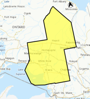
Yellow Advisory – Freezing Drizzle
Area affected by the updated freezing drizzle alert.
Impact Level: Moderate
Forecast Confidence: High
Areas of freezing drizzle are expected.
Patchy freezing drizzle continues over some areas this morning.
Light ice build up on surfaces is possible.
Roads, walkways, and other surfaces will likely become icy and slippery. Icy surfaces will likely form and could be difficult to detect. Be very careful if walking or driving.
Jan 6, 2026 at 15:42
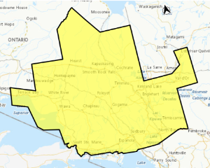
All the areas in Yellow are affected with the freezing drizzle warning.
Yellow Advisory – Freezing Drizzle
Impact Level: Moderate
Forecast Confidence: High
Areas of freezing drizzle are expected.
Freezing drizzle is possible or occurring over some areas.
Light ice build up on some surfaces is possible this afternoon and tonight.
Roads, walkways, and other surfaces will likely become icy and slippery. Icy surfaces will likely form and could be difficult to detect.
Be very careful if walking or driving.
Orange Alert = Severe weather
Red Alert = Very dangerous and possibly life-threatening weather
For road conditions and other traveller information from the Ministry of Transportation, visit https://www.ontario.ca/511, or call 5-1-1.
Please continue to monitor alerts and forecasts issued by Environment Canada. To report severe weather, send an email to [email protected] or tweet reports using #ONStorm.
- Yellow Warning – Rainfall (Montreal River – Searchmont) - January 8, 2026
- Wintry Mix Expected (Wawa – Pukaskwa Park) – Jan 8 at 6:56 - January 8, 2026
- Snowfall Warning for Tonight (Montreal River – St. Joseph Island) ENDED - January 5, 2026
