Wawa-news.com Local and Regional News
Nov 22, 2021 at 05:40
5:36 AM EST Monday 22 November 2021
Snow squall warning in effect for:
- Sault Ste. Marie – St. Joseph Island
- Searchmont – Montreal River Harbour – Batchawana Bay
Persons in or near this area should be on the lookout for adverse weather conditions and take necessary safety precautions. Watch for updated statements.
Nov 22, 2021 at 05:17
5:04 AM EST Monday 22 November 2021
Snow squall warning in effect for:
- Sault Ste. Marie – St. Joseph Island
- Searchmont – Montreal River Harbour – Batchawana Bay
Snow squalls continue today.
Snow squalls are expected to continue today before slowing weakening tonight.
There is potential for local snowfall amounts of 15 cm or more per 12 hours in the strongest snow squalls, along with sudden near zero visibility in bursts of heavy snow and blowing snow. Total snowfall accumulations may reach 30 cm by the end of the event, especially if a snow squall can lock in over a particular location for a few hours.
Very strong northwesterly winds will also whip up freshly fallen snow and cause sudden near zero visibility from blowing snow in exposed areas at times.
Visibility will be suddenly reduced to near zero at times in heavy snow and blowing snow. Rapidly accumulating snow could make travel difficult over some locations. Consider postponing non-essential travel until conditions improve. Road closures are possible.
4:15 AM EST Monday 22 November 2021
Wind warning in effect for:
- Sault Ste. Marie – St. Joseph Island
- Searchmont – Montreal River Harbour – Batchawana Bay
Very strong winds gusts that may cause damage are expected.
Northwest winds gusting to near 90 km/h are expected this morning.
The winds are expected to ease late this morning.
A few power outages are possible.
Damage to buildings, such as to roof shingles and windows, may occur. Loose objects may be tossed by the wind and cause injury or damage. Be prepared to adjust your driving with changing road conditions due to high winds.
4:22 AM EST Monday 22 November 2021
Weather advisory ended for:
- Agawa – Lake Superior Park
Nov 21, 2021 at 23:15
10:32 PM EST Sunday 21 November 2021
Weather advisory in effect for:
- Agawa – Lake Superior Park
Winter weather travel advisory in effect.
Snow squalls possible tonight.
Lake effect snow bands off of Lake Superior are expected to develop this evening in a strong northwesterly flow of much colder air from the Arctic. The lake effect snow bands should slowly sink southward tonight before moving out of the region by early Monday morning.
Locally snowfall accumulations of 5 to 10 cm are possible, along with sudden near zero visibility in bursts of heavy snow and blowing snow. Travel is likely to be affected.
Strong northwesterly winds are expected near Lake Superior in the wake of the cold front this evening which will reduce visibilities in blowing snow at times. Isolated power outages are also possible.
Motorists should expect hazardous winter driving conditions and adjust travel plans accordingly. Travel may be hazardous due to sudden changes in the weather. If visibility is reduced while driving, slow down, watch for tail lights ahead and be prepared to stop.
Nov 21, 2021 at 21:45
9:38 PM EST Sunday 21 November 2021
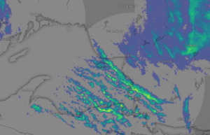
Image from windy.com
Wind warning in effect for:
- Sault Ste. Marie – St. Joseph Island
- Searchmont – Montreal River Harbour – Batchawana Bay
Very strong winds gusts that may cause damage are expected.
Northwest winds gusting to near 100 km/h are expected this evening in the wake of a sharp cold front.
The winds are expected to remain strong and gusty throughout the night, easing slightly overnight into Monday.
A few power outages are possible.
Damage to buildings, such as to roof shingles and windows, may occur. Loose objects may be tossed by the wind and cause injury or damage. Be prepared to adjust your driving with changing road conditions due to high winds.
4:28 PM EST Sunday 21 November 2021
Snow squall warning in effect for:
- Sault Ste. Marie – St. Joseph Island
- Searchmont – Montreal River Harbour – Batchawana Bay
Snow squalls beginning this evening and continuing Monday.
Strong snow squalls off of Lake Superior will develop this evening in a strong northwesterly flow of much colder air from the Arctic. Snow squalls are expected to continue Monday before slowing weakening Monday night.
There is potential for local snowfall amounts of 15 cm or more per 12 hours in the strongest snow squalls, along with sudden near zero visibility in bursts of heavy snow and blowing snow. Total snowfall accumulations may reach 30 cm by the end of the event, especially if a snow squall can lock in over a particular location for a few hours.
Very strong northwesterly winds will also whip up freshly fallen snow and cause sudden near zero visibility from blowing snow in exposed areas at times.
Visibility will be suddenly reduced to near zero at times in heavy snow and blowing snow. Rapidly accumulating snow could make travel difficult over some locations. Consider postponing non-essential travel until conditions improve. Road closures are possible.
4:13 PM EST Sunday 21 November 2021
Weather advisory in effect for:
- Agawa – Lake Superior Park
Winter weather travel advisory in effect.
Snow squalls possible tonight.
Lake effect snow bands off of Lake Superior are expected to develop this evening in a strong northwesterly flow of much colder air from the Arctic. The lake effect snow bands should slowly sink southward tonight before moving out of the region by early Monday morning.
Locally snowfall accumulations of 5 to 10 cm are possible, along with sudden near zero visibility in bursts of heavy snow and blowing snow. Travel is likely to be affected.
Strong northwesterly winds are expected near Lake Superior in the wake of the cold front this evening which will reduce visibilities in blowing snow at times. Isolated power outages are also possible.
Motorists should expect hazardous winter driving conditions and adjust travel plans accordingly. Travel may be hazardous due to sudden changes in the weather. If visibility is reduced while driving, slow down, watch for tail lights ahead and be prepared to stop.
For road conditions and other traveller information from the Ministry of Transportation, visit https://www.ontario.ca/511, https://www.twitter.com/511Ontario, or call 5-1-1.
Please continue to monitor alerts and forecasts issued by Environment Canada. To report severe weather, send an email to [email protected] or tweet reports using #ONStorm.
Orange Alert = Severe weather
Red Alert = Very dangerous and possibly life-threatening weather
For road conditions and other traveller information from the Ministry of Transportation, visit https://www.ontario.ca/511, or call 5-1-1.
Please continue to monitor alerts and forecasts issued by Environment Canada. To report severe weather, send an email to [email protected] or tweet reports using #ONStorm.
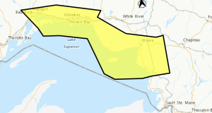
- Yellow Fog Advisory (Nipigon – Rossport) ENDED - July 26, 2026
- Yellow Fog Advisory (Marathon – Schreiber) ENDED - July 26, 2026
- Yellow Fog Advisory (Agawa – Lake Superior Park) ENDED - July 26, 2026