Wawa-news.com Local and Regional News
Mar 16, 2026 at 05:46
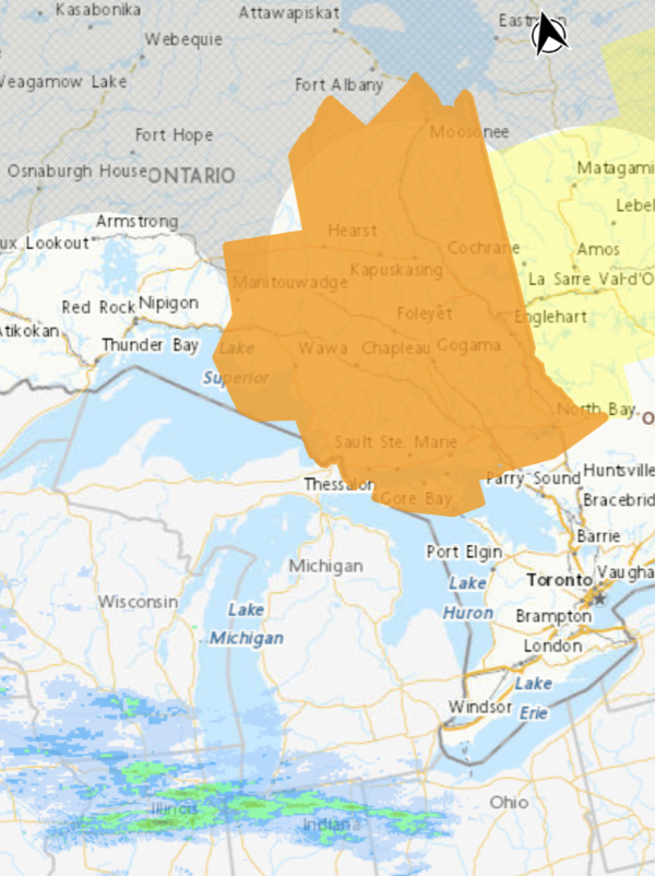
Orange Warning – Winter Storm
Impact Level: Extreme
Forecast Confidence: High
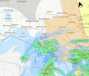
Major winter storm continues.
What:
- Total snowfall accumulations of 30 to 50 cm.
- Near zero visibility in heavy snow and blowing snow.
- Northeasterly wind gusts of 70 to 80 km/h.
When: Continuing through tonight.
Additional information: Precipitation will primarily be rapidly accumulating snowfall, however, there is a chance that ice pellets could mix in for areas along a line from Sault Ste. Marie to Kirkland Lake. This would serve to reduce total snowfall amounts.
Travel will likely be extremely hazardous and some routes will likely be impassable. Road closures are possible.
Prolonged, widespread utility outages are likely. Roofs are at an increased risk of collapse under the weight of snow.
All travel and outdoor activities should be avoided.
Prepare for prolonged, widespread disruptions to transportation, services, and utilities.
Mar 14, 2026 at 21:51
Orange Warning – Winter Storm
Impact Level: Extreme
Forecast Confidence: High
Major winter storm expected.
What:
- Total snowfall accumulations of 40 to 80 cm.
- Near zero visibility in heavy snow and blowing snow.
- Northeasterly wind gusts of 70 to 80 km/h.
- Risk of freezing rain and ice pellets.
- Possible utility outages.
When: Sunday morning or afternoon through Monday night.
Additional information: A hazardous winter storm will begin affecting northeastern Ontario on Sunday. Precipitation will primarily be rapidly accumulating snowfall. However, there is a chance that freezing rain or ice pellets could mix in for areas along a line from Sault Ste. Marie to Kirkland Lake, reducing their total snowfall amounts.
Travel on Highways 11, 17, and 101 will be impacted. Travel will likely be extremely hazardous and some routes will likely be impassable. Road closures are possible.
Roofs are at an increased risk of collapse under the weight of snow.
All travel and outdoor activities should be avoided.
 Mar 14, 2026 at 14:22
Orange Warning – Winter Storm
Impact Level: Extreme
Forecast Confidence: High
Major winter storm expected.
What:
- Total snowfall accumulations of 40 to 80 cm.
- Near zero visibility in heavy snow and blowing snow.
- Northeasterly wind gusts of 70 to 80 km/h.
- Risk of freezing rain and ice pellets.
- Possible utility outages.
When: Sunday morning or afternoon through Monday night.
Additional information: A hazardous winter storm will begin affecting northeastern Ontario on Sunday. Precipitation will primarily be rapidly accumulating snowfall however there is a chance freezing rain or ice pellets could mix in for southern regions on a line from Sault Ste. Marie to Kirkland Lake, reducing their total snowfall amounts.
Travel on Highways 11, 17 and 101 will be impacted. Travel will likely be extremely hazardous and some routes will likely be impassable. Visibility will likely be suddenly reduced to near zero at times. Road closures are possible.
Roofs are at an increased risk of collapse under the weight of snow.
All travel and outdoor activities should be avoided.
Mar 14, 2026 at 10:21
Orange Watch – Winter Storm
Impact Level: High
Forecast Confidence: High
Major winter storm expected.
What:
- Total snowfall accumulations of 30 to 50 cm.
- Near zero visibility in heavy snow and blowing snow.
- Wind gusts of 70 to 80 km/h. Ice buildup from freezing rain.
When: Sunday through Monday night.
Additional information: Confidence is increasing in a hazardous winter storm impacting northeastern Ontario.
At this time, most regions are expected to see rapidly accumulating snowfall and blowing snow. Regions from Manitoulin Island toward Kirkland Lake and east are expected to switch over to freezing rain or ice pellets by Monday, lowering their total snowfall amounts.
Travel on Highways 11, 17 and 101 will be impacted. Visibility may be suddenly reduced to near zero at times.
Road closures are possible.
Prolonged utility outages are possible.
Prepare for possibly prolonged disruptions to transportation, services, and utilities.
Mar 13, 2026 at 18:19
Orange Watch – Winter Storm
Impact Level: High
Forecast Confidence: High
Major winter storm expected.
What:
 Total snowfall accumulations of 30 to 50 cm.
- Near zero visibility in heavy snow and blowing snow.
- Wind gusts of 70 to 80 km/h.
- Ice buildup from freezing rain.
When: Sunday through Monday night.
Additional information: Confidence is increasing in a hazardous winter storm impacting northeastern Ontario.
At this time, most regions are expected to see rapidly accumulating snowfall and blowing snow. Regions from Manitoulin Island toward Kirkland Lake and east are expected to switch over to freezing rain or ice pellets by Monday, lowering their total snowfall amounts.
Travel on Highways 11, 17 and 101 will be impacted. Visibility may be suddenly reduced to near zero at times. Road closures are possible.
Prolonged utility outages are possible.
Prepare for possibly prolonged disruptions to transportation, services, and utilities.
Orange Alert = Severe weather
Red Alert = Very dangerous and possibly life-threatening weather
For road conditions and other traveller information from the Ministry of Transportation, visit https://www.ontario.ca/511, or call 5-1-1.
Please continue to monitor alerts and forecasts issued by Environment Canada. To report severe weather, send an email to [email protected] or tweet reports using #ONStorm.
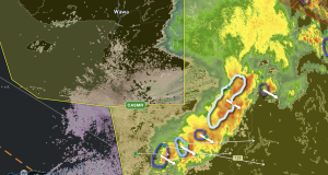
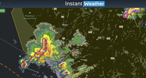
- Severe Thunderstorm (White River – Dubreuilville) ENDED - June 29, 2026
- Severe Thunderstorm (Manitouwadge – Hornepayne) ENDED - June 29, 2026
- Severe Thunderstorm (Wawa – Pukaskwa Park) ENDED - June 29, 2026