Wawa-news.com Local and Regional News
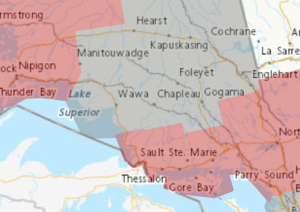
Pink (Thunder Bay – North and northwest) = Winter Storm Warning, Grey = Special Weather Statement, Pink (SSM and regions east) = Freezing Rain Warning.
reezing rain is likely on Wednesday.
An intensifying Colorado Low is expected to track over northwestern Ontario on Wednesday. Snow and ice pellets accumulations of 5 to 10 cm are possible ahead of this system that is forecast to move into northeastern Ontario tonight before likely transitioning to freezing rain on Wednesday.
As temperatures change, some areas may see snow and ice pellets then change to rain later Wednesday or Wednesday night while others could see a change back to snow.
Be careful as surfaces such as highways, roads, walkways and parking lots may become icy and slippery. Strong wind gusts up to 60 km/h.
Uncertainty remains regarding the track of this system which could change the location of the freezing rain and snowfall amounts.

- Thursday Morning New – July 23rd - July 23, 2026
- Between the Covers – July 22 - July 22, 2026
- Wednesday Morning News – July 22nd - July 22, 2026