Wawa-news.com You can't hear the 'big picture'!
Mar 30, 2025 at 08:00
 |
 |
 |
Special Weather Statement in effect for:
- Wawa – Pukaskwa Park
Significant snowfall possible today and tonight.
What:
- Snowfall amounts up to 10 cm. ‘
When: Beginning this morning and ending overnight.
The region may be affected by the northwestern edge of a winter storm. Up to 10 cm of snowfall is possible in the Wawa area, although it is possible that the region will receive less depending on the track of the low pressure system.
Note that for areas to the south and east, winter storm warnings are in effect where significantly higher snowfall totals and the threat of freezing rain are expected.
Mar 28, 2025 at 22:10
Special Weather Statement in effect for:
- Wawa – Pukaskwa Park
Potential for significant snowfall Sunday.
What:
- Snowfall totals possibly exceeding 15 cm.
- Risk of freezing rain.
When: Sunday.
Another weather system will affect portions of northeastern Ontario on Sunday with significant snowfall amounts possible. Depending on the track of the low pressure system, some areas may see a changeover to ice pellets or freezing rain.
Regardless of precipitation type, hazardous travel conditions are likely. Conditions should improve by Monday morning as the weather system exits the province.
Weather Advisory in effect for:
- Wawa – Pukaskwa Park
Winter weather travel advisory in effect for today.
What:
- Total snowfall accumulations of 7 to 15 cm.
- Reduced visibility in areas of heavier snow.
- Difficult travel conditions.
When: Tapering off tonight.
Snow associated with a low pressure system is expected to affect areas north of Lake Superior today.
Travel along portions of Highway 17 may be affected. Motorists should expect hazardous winter driving conditions and adjust travel plans accordingly. Be prepared to adjust your driving with changing road conditions. If visibility is reduced while driving, slow down, watch for tail lights ahead and be prepared to stop.
Mar 28, 2025 at 07:55
Snowfall Warning in effect for:
- Wawa – Pukaskwa Park
Significant snowfall expected today into tonight.
What:
- Total snowfall amounts of 10 to 20 cm.
- Reduced visibility in heavy snow.
- Difficult travel conditions and possible road closures.
When: Beginning this morning or this afternoon, and ending Saturday morning.
Snow is expected to begin affecting northeastern Ontario during the day before intensifying late in the day or this evening. Snow will taper off by Saturday morning.
After a brief break Saturday, another winter storm will likely affect the region on Sunday with a threat of significant snowfall, freezing rain and ice pellets. More details on precipitation amounts will come in future updates.
Rapidly accumulating snow could make travel difficult over some locations. Prepare for quickly changing and deteriorating travel conditions. If visibility is reduced while driving, slow down, watch for tail lights ahead and be prepared to stop.
Mar 27, 2025 at 16:01
Special Weather Statement in effect for:
- Wawa – Pukaskwa Park
Significant snowfall with a spring storm is expected.
What:
- Total snowfall accumulations of 15 to 25 cm.
- Amounts in excess of 25 cm are possible over some areas.
- Reduced visibility in heavy snow.
- Risk of freezing rain and ice pellets on Sunday.
- Difficult travel conditions and possible road closures.
When: Friday afternoon into Monday.
Additional information: Two rounds of snow are expected with the passage of two low pressure systems.
The first round of snow is expected Friday afternoon into Saturday morning.
The second round is expected to begin Sunday which will bring snow and ice pellets along with the risk of freezing rain.
There remains uncertainty with the swath of heaviest snow at this time. Warnings will likely be issued as the event draws nearer.
Please continue to monitor alerts and forecasts issued by Environment Canada. To report severe weather, send an email to [email protected] or tweet reports using #ONStorm.
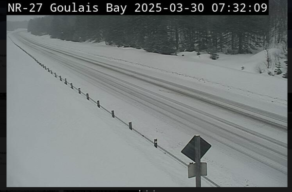
- Significant snowfall possible (Wawa – Pukaskwa Park) - March 30, 2025
- Significant snowfall Sunday (White River – Dubreuilville) - March 30, 2025
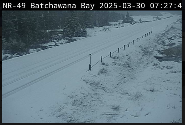
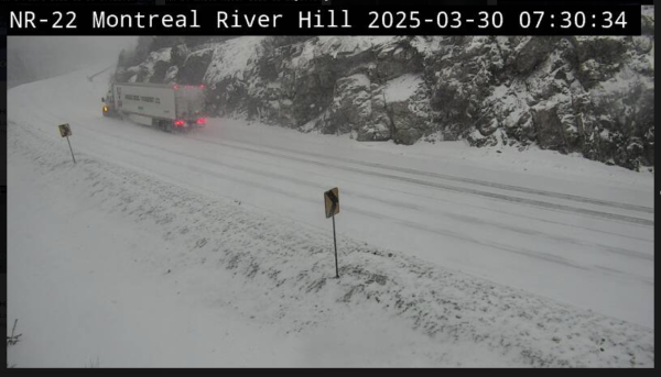
- Winter Storm Warning (Searchmont – Montreal River Harbour – Batchawana Bay) - March 30, 2025