Wawa-news.com Local and Regional News
Dec 6, 2021 at 06:20
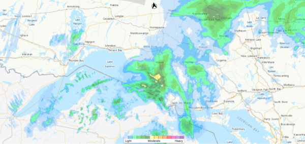
This low-pressure system will track east across the Great Lakes today bringing snow. Snow is expected to gradually taper to flurries by this evening.
Motorists should expect hazardous winter driving conditions and adjust travel plans accordingly. Surfaces such as highways, roads, walkways and parking lots may become difficult to navigate due to accumulating snow. Visibility may be suddenly reduced at times in heavy snow.
| brief synopsis | updated | ||||
| Snowfall Warning | Elliot Lake – Ranger Lake | Elliot Lake – Ranger Lake | heavy snow – 15-20cm | 5:29 a.m. | Dec. 5, 9:59 a.m. |
| Snowfall Warning | Sault Ste. Marie – Superior East | Searchmont – Montreal River Harbour – Batchawana Bay – St. Joseph Island | heavy snow – 15cm | Dec 6, 5:30 a.m. | Dec 6, 5:30 a.m. |
| Snowfall Warning | Sault Ste. Marie – Superior East | Agawa – Lake Superior Park | heavy snow – 15-20cm | 5:41 a.m. | Dec 6, 5:41 a.m. |
| Winter weather travel advisory in effect | Wawa – White River – Pukaskwa | Wawa – Pukaskwa Park – White River – Dubreuilville | heavy snow – 10-15cm | 5:42 a.m. | Dec 5, 9:18 a.m. |
| Winter weather travel advisory in effect | Chapleau – Gogama | Chapleau – Missinaibi Lake – Gogama – Foleyet | heavy snow – 10-15cm | 5:42 a.m. | Dec 5, 9:18 a.m. |
Dec 5, 2021 at 21:45
| brief synopsis | updated | ||||
| Snowfall Warning | Elliot Lake – Ranger Lake | Elliot Lake – Ranger Lake | heavy snow – 15-20cm | 4:18 p.m. | 9:59 a.m. |
| Snowfall Warning | Sault Ste. Marie – Superior East | Searchmont – Montreal River Harbour – Batchawana Bay | heavy snow – 15-20cm | 9:41 p.m. | 9:37 a.m. |
| Winter Storm Warning | Sault Ste. Marie – Superior East | Sault Ste. Marie – St. Joseph Island | heavy snow, 20-30cm, 70km/h winds | 4:17 p.m. | 9:37 a.m. |
| Winter weather travel advisory in effect | Sault Ste. Marie – Superior East | Agawa – Lake Superior Park | heavy snow – 10-15cm | 9:33 p.m. | 9:18 a.m. |
| Winter weather travel advisory in effect | Wawa – White River – Pukaskwa | Wawa – Pukaskwa Park – White River – Dubreuilville | heavy snow – 10-15cm | 9:33 p.m. | 9:18 a.m. |
| Winter weather travel advisory in effect | Chapleau – Gogama | Chapleau – Missinaibi Lake – Gogama – Foleyet | heavy snow – 10-15cm | 4:13 p.m. | 9:18 a.m. |
Dec 5, 2021 at 18:16
| brief synopsis | updated | ||||
| Snowfall Warning | Elliot Lake – Ranger Lake | Elliot Lake – Ranger Lake | heavy snow – 15-20cm | 9:59 a.m. | |
| Snowfall Warning | Sault Ste. Marie – Superior East | Searchmont – Montreal River Harbour – Batchawana Bay | heavy snow – 15-20cm | 4:18 p.m. | 9:37 a.m. |
| Winter Storm Warning | Sault Ste. Marie – Superior East | Sault Ste. Marie – St. Joseph Island | heavy snow, 20-30cm, 70km/h winds | 4:17 p.m. | 9:37 a.m. |
| Winter weather travel advisory in effect | Sault Ste. Marie – Superior East | Agawa – Lake Superior Park | heavy snow – 10-15cm | 4:13 p.m. | 9:18 a.m. |
| Winter weather travel advisory in effect | Wawa – White River – Pukaskwa | Wawa – Pukaskwa Park – White River – Dubreuilville | heavy snow – 10-15cm | 4:13 p.m. | 9:18 a.m. |
| Winter weather travel advisory in effect | Chapleau – Gogama | Chapleau – Missinaibi Lake – Gogama – Foleyet | heavy snow – 10-15cm | 4:13 p.m. | 9:18 a.m. |
Traffic cameras show:
Montreal River Hill – bare and wet
Red Rock Lake – snow covered
Dubreuilville Junction – bare and wet
Goulais Bay – snow covered, slushy looking
Heyden – wheel rut bare, slushy looking
Dec 5, 2021 at 09:47
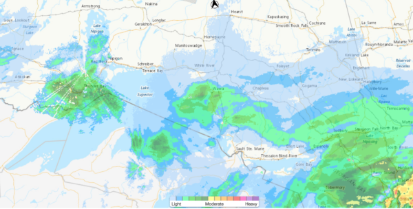
A low-pressure system will track east across the Great Lakes today through Monday, bringing snow. There remains some uncertainty in the track of this system and the snowfall amounts expected. Snowfall warnings may be issued as the event approaches.
Environment Canada has warned in the Superior West & Thunder Bay areas – “Consider postponing non-essential travel until conditions improve. Surfaces such as highways, roads, walkways and parking lots may become difficult to navigate due to accumulating snow. Visibility will be suddenly reduced to near zero at times in heavy snow and blowing snow.”
Given the amount and rate of snow (reports are of 2″ in an hour) that fell yesterday in the Goulais River area causing multiple collisions, and slippery hills… if travel is not required, you may wish to reschedule.
Traffic cameras show:
Montreal River Hill – bare and wet
Red Rock Lake – bare and wet
Dubreuilville Junction – bare and wet
Goulais Bay – bare and wet
Heyden – bare and wet
Please check with Environment Canada or your preferred weather information source for detailed and current information.
Dec 5, 2021 at 09:59
| brief synopsis | Updated | Finish | ||||
| Snowfall Warning | Elliot Lake – Ranger Lake | Elliot Lake – Ranger Lake | heavy snow – 15-20cm | 9:59 a.m. | ||
| Snowfall Warning | Sault Ste. Marie – Superior East | Searchmont – Montreal River Harbour – Batchawana Bay | heavy snow – 15-20cm | 9:37 a.m. | 9:59 | |
| Winter Storm Warning | Sault Ste. Marie – Superior East | Sault Ste. Marie – St. Joseph Island | heavy snow, 20-30cm, 70km/h winds | 9:37 a.m. | ||
| Winter weather travel advisory in effect | Sault Ste. Marie – Superior East | Agawa – Lake Superior Park | heavy snow – 15-20cm | 9:18 a.m. | ||
| Winter weather travel advisory in effect | Wawa – White River – Pukaskwa | Wawa – Pukaskwa Park – White River – Dubreuilville | heavy snow – 10-15cm | 9:18 a.m. | ||
| Winter weather travel advisory in effect | Chapleau – Gogama | Chapleau – Missinaibi Lake – Gogama – Foleyet | heavy snow – 10-15cm | 9:18 a.m. |

- Tuesday Morning News – July 21st - July 21, 2026
- Monday Morning News – July 20th - July 20, 2026
- Wawa FD called to Backyard Bonfire during RFZ - July 19, 2026