Wawa-news.com Local and Regional News
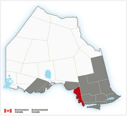 A strengthening low-pressure system is expected to track east across the Great Lakes Sunday through Monday. There remains some uncertainty in the track of this low-pressure system and as a result, the snowfall amounts and areas affected by freezing rain and heavy rain could change. At this time, areas north and west of Sudbury are expected to receive mainly snow, whereas areas east and south of Sudbury could see a wintry mix of precipitation. Warnings will be issued as the event draws nearer.
Wawa – Pukaskwa Park – White River – Dubreuilville – Chapleau – Missinaibi Lake – Gogama – Foleyet – Elliot Lake – Ranger Lake – Blind River – Thessalon – Espanola – Killarney – Manitoulin Island – Greater Sudbury and vicinity – Kirkland Lake – Englehart – Temiskaming Shores – Temagami – Timmins – Cochrane – Iroquois Falls – North Bay – Powassan – Mattawa – West Nipissing – French River
Winter storm expected Sunday afternoon through Monday bringing heavy snow with total snowfall accumulations of 10 to 25 cm. Strong winds with gusts of 60 to 70 km/h and risk of freezing rain for some areas. Heavy rain for some areas. As a result hazardous travel conditions are expected.
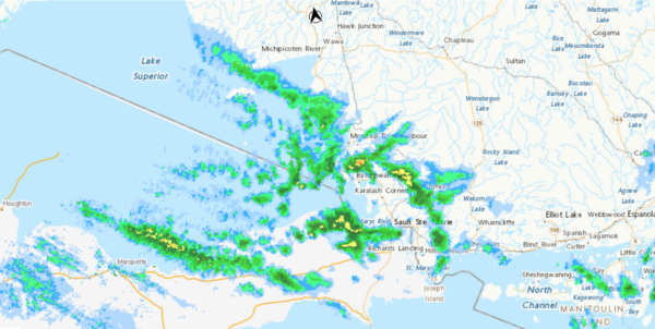
Agawa – Lake Superior Park – Sault Ste. Marie – St. Joseph Island
Winter weather travel advisory is in effect today through tonight with 15 to 25 cm snow possible by tonight. Hazardous travel conditions due to accumulating snow and poor visibility in bursts of heavy snow.
Snow squalls are expected to develop this morning and persist into this evening. Snow squall warnings may be issued as the situation warrants.
Motorists should expect hazardous winter driving conditions and adjust travel plans accordingly. Surfaces such as highways, roads, walkways and parking lots may become difficult to navigate due to accumulating snow. Visibility may be suddenly reduced at times in heavy snow. Snow squalls cause weather conditions to vary considerably; changes from clear skies to heavy snow within just a few kilometres are common.
Searchmont – Montreal River Harbour – Batchawana Bay
Snow squalls are expected. Under the snow squall bands, visibilities will be significantly reduced due to the heavy snow, and snow will quickly accumulate this morning through Saturday night. 15 to 25 cm snow is likely by tonight.
Snow squalls are expected to develop this morning or early and persist into this evening.
Snow squalls cause weather conditions to vary considerably; changes from clear skies to heavy snow within just a few kilometres are common. Visibility may be suddenly reduced at times in heavy snow. Travel is expected to be hazardous due to reduced visibility in some locations. Be prepared to adjust your driving with changing road conditions.

- Tuesday Morning News – July 21st - July 21, 2026
- Monday Morning News – July 20th - July 20, 2026
- Wawa FD called to Backyard Bonfire during RFZ - July 19, 2026