Wawa-news.com Local and Regional News
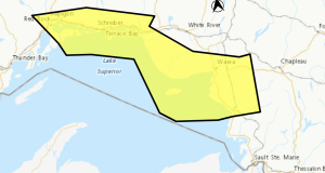
 Winter storm watch in effect for:
- Wawa – Pukaskwa Park
- White River – Dubreuilville
A significant winter storm is expected Sunday night into Monday.
A low-pressure system is expected to track over Northeastern Ontario Monday bringing snow and blowing snow to the area. Snow is expected to begin late Sunday evening before becoming heavy overnight. Northerly winds gusting near 60 or 70 km/h are also likely resulting in widespread blowing snow. Snow and blowing snow will continue Monday and taper to flurries Monday night.
Total snowfall amounts near 25 to 35 cm are possible.
There is some uncertainty in snowfall amounts as a slight shift in the track and strength of this low-pressure system may drastically change associated snowfall amounts.
Avoid travel if possible. Surfaces such as highways, roads, walkways and parking lots may become icy and slippery.
Special weather statement in effect for:
- Agawa – Lake Superior Park
- Chapleau – Missinaibi Lake
A significant snowfall is expected Sunday night into Monday.
A low-pressure system is expected to track over Northeastern Ontario Monday bringing snow and blowing snow to the area. Snow is expected to begin late Sunday evening before becoming heavy overnight. Snow may mix with or change to rain on Monday. There is also a risk of freezing rain Monday morning. Snow is expected to taper to flurries Monday night.
Northerly winds gusting near 60 or 70 km/h are also likely Monday evening resulting in blowing snow.
Total snowfall amounts near 10 to 20 cm are possible.
There is uncertainty in snowfall amounts as a slight shift in the track and strength of this low-pressure system may drastically change associated snow and rainfall amounts.

- Northeast Forest Fire Update – July 25 - July 26, 2026
- Northwest Forest Fire Update – July 25 - July 26, 2026
- This Weekend at LSPP – Saturday, July 25 & Sunday, July 26th - July 25, 2026