Wawa-news.com Local and Regional News
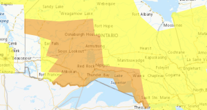
Special weather statement in effect for:
- Wawa – Pukaskwa Park
- White River – Dubreuilville
Significant snowfall Thursday into Friday.
A significant snowfall is expected to begin near Lake Superior early Thursday morning and spread northeastward towards James Bay throughout the day. The latest analysis suggests snowfall amounts of 15 to 30 cm are possible by the time the snow ends on Friday.
Travel is expected to be hazardous due to reduced visibility and rapidly accumulating snow.
Snowfall or Winter Storm Warnings will likely be required as the event approaches.
Special weather statement in effect for:
- Sault Ste. Marie – St. Joseph Island
- Searchmont – Montreal River Harbour – Batchawana Bay
A wintry mix expected beginning Thursday afternoon.
Snow or ice pellets along with a risk of freezing rain will begin Thursday afternoon and taper off early Friday morning. Snowfall and ice pellet accumulations will vary widely but could reach up to 10 centimetres by the time it ends Friday morning.
Hazardous winter travelling conditions are expected Thursday through Friday morning. Motorists should exercise caution and expect longer travel times.
Environment and Climate Change Canada will continue to monitor this developing situation closely.
4:45 AM EST Wednesday 06 February 2019
Special weather statement in effect for:
- Agawa – Lake Superior Park
Significant snowfall Thursday into Friday.
A significant snowfall is expected to begin near Lake Superior early Thursday morning and spread northeastward towards James Bay throughout the day. The latest analysis suggests snowfall amounts of 15 to 30 cm are possible by the time the snow ends on Friday.
Travel is expected to be hazardous due to reduced visibility and rapidly accumulating snow.
Snowfall or Winter Storm Warnings will likely be required as the event approaches.

- Monday Morning News – July 20th - July 20, 2026
- Wawa FD called to Backyard Bonfire during RFZ - July 19, 2026
- Fort Frances 14: Evacuation Order & Expanded Evacuation Alert - July 18, 2026