Wawa-news.com Local and Regional News
5:02 AM EST Monday 04 February 2019
Snowfall warning in effect for:
- Wawa – Pukaskwa Park
- White River – Dubreuilville
Snowfall with total amounts of 15 to 20 cm is expected.
Significant snowfall today and tonight.
Snow at times heavy will begin early this morning and end overnight. Northeast winds gusting up to 50 km/h will also generate local blowing snow, leading to reduced visibilities.
Prepare for quickly changing and deteriorating travel conditions. Surfaces such as highways, roads, walkways and parking lots may become difficult to navigate due to accumulating snow. If visibility is reduced while driving, slow down, watch for tail lights ahead and be prepared to stop.
Snowfall warnings are issued when significant snowfall is expected.
5:05 AM EST Monday 04 February 2019
Special weather statement in effect for:
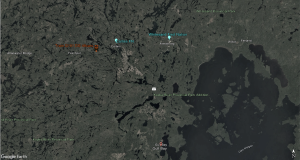
- Agawa – Lake Superior Park
Significant snowfall today into tonight.
Snow and ice pellets will spread over Northeastern Ontario early this morning. Total snowfall amounts of 10 to 15 cm are possible by the time the snow ends overnight. There is also the risk of freezing rain.
Hazardous winter driving conditions are anticipated.
5:06 AM EST Monday 04 February 2019
Freezing rain warning in effect for:
- Sault Ste. Marie – St. Joseph Island
- Searchmont – Montreal River Harbour – Batchawana Bay
Freezing rain is expected or occurring.
Freezing rain will begin early this afternoon. Several hours of freezing rain are expected before it ends later this afternoon or this evening.
Surfaces such as highways, roads, walkways and parking lots may become icy and slippery. Slow down driving in slippery conditions. Watch for taillights ahead and maintain a safe following distance.

- Today at LSPP – Monday, July 20th - July 20, 2026
- Air Quality – Yellow Alert (July 20) - July 20, 2026
- Evacuation Order – Thunder Bay 36, 54 & 56 and Dryden 34 & 35 - July 20, 2026