 Wawa-news.com Local and Regional News
May 25, 2018 @ 11:24
 11:02 AM EDT Friday 25 May 2018
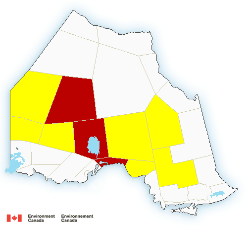
Severe thunderstorm watch in effect for:
- White River – Dubreuilville
- Chapleau – Missinaibi Lake
Thunderstorms are expected to affect portions of northern Ontario today. Some of these thunderstorms will have the potential to produce large hail and damaging wind gusts.
Locally significant rainfall is also possible in areas that receive several thunderstorms.
The severe thunderstorm threat will diminish later this evening.
Large hail can damage property and cause injury. Strong wind gusts can toss loose objects, damage weak buildings, break branches off trees and overturn large vehicles. Locally heavy rain is also possible. Lightning kills and injures Canadians every year. Remember, when thunder roars, go indoors!
Severe thunderstorm watches are issued when atmospheric conditions are favourable for the development of thunderstorms that could produce one or more of the following: large hail, damaging winds, torrential rainfall.
The Office of the Fire Marshal and Emergency Management recommends that you take cover immediately if threatening weather approaches.
Please continue to monitor alerts and forecasts issued by Environment Canada. To report severe weather, send an email to [email protected] or tweet reports using #ONStorm.
Editor’s Note – as of 11:56 Wawa has dropped 10C in the last hour, so weather is changing.

- First Nation Leaders to Hold Press Conference to Address Ontario’s Wildfire Response - July 21, 2026
- Northwestern Ontario Community Support Fund Established - July 21, 2026
- Men’s Night Golf – Results of July 16th - July 21, 2026