 Wawa-news.com Local and Regional News
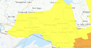
The Ministry of Natural Resources – Chapleau Wawa District is advising area residents that a Flood Watch is in effect in the District until Wednesday, April 08, 2026 at 4:00pm. Residents in the Chapleau Wawa District area should keep a close watch on conditions and exercise caution around lakes, rivers, creeks and streams. Roads and walkways will likely be difficult ...
Read More »Weather Alerts
Winter Storm Today (Chapleau – Missinaibi Lake)
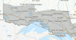
Apr 4, 2026 at 07:13 Yellow Warning – Winter Storm 5:22 AM EDT Saturday 4 April 2026 Impact Level: Moderate Forecast Confidence: High Hazardous winter conditions expected today. What: Total snowfall and ice pellet amounts of 10 to 15 cm. Peak snowfall rates of 2 to 4 cm per hour. Reduced visibility in heavy snow and local blowing snow. Freezing ...
Read More »Winter Storm Today (Agawa – Lake Superior Park)
Apr 4, 2026 at 07:13 Yellow Warning – Winter Storm 5:22 AM EDT Saturday 4 April 2026 Impact Level: Moderate Forecast Confidence: High Hazardous winter conditions expected today. What: Total snowfall and ice pellet amounts of 10 to 15 cm. Peak snowfall rates of 2 to 4 cm per hour. Reduced visibility in heavy snow and local blowing snow. Freezing ...
Read More »Snowfall Today (Wawa – Pukaskwa Park)
Apr 4, 2026 at 07:13 Yellow Warning – Winter Storm 5:22 AM EDT Saturday 4 April 2026 Impact Level: Moderate Forecast Confidence: High Snowfall with total amounts of 10 to 20 cm is expected. What: Total snowfall amounts of 10 to 20 cm. Peak snowfall rates of 2 to 4 cm per hour. Reduced visibility in heavy snow and local ...
Read More »Snowfall Today (White River – Dubreuilville)
Apr 4, 2026 at 07:13 Yellow Warning – Winter Storm 5:30 AM EDT Saturday 4 April 2026 Impact Level: Moderate Forecast Confidence: High Snowfall with total amounts of 10 to 20 cm is expected. What: Total snowfall amounts of 10 to 20 cm. Peak snowfall rates of 2 to 4 cm per hour. Reduced visibility in heavy snow and local ...
Read More »Snowfall Today (Manitouwadge – Hornepayne)
Apr 4, 2026 at 07:13 Yellow Warning – Winter Storm 5:30 AM EDT Saturday 4 April 2026 Impact Level: Moderate Forecast Confidence: High Snowfall with total amounts of 10 to 20 cm is expected. What: Total snowfall amounts of 10 to 20 cm. Peak snowfall rates of 2 to 4 cm per hour. Reduced visibility in heavy snow and local ...
Read More »Snowfall Today (Marathon – Schreiber)
Apr 4, 2026 at 07:13 Yellow Warning – Winter Storm 5:15 AM EDT Saturday 4 April 2026 Impact Level: Moderate Forecast Confidence: High Snowfall with total amounts of 15 to 30 cm is expected. What: Total snowfall amounts of 15 to 30 cm. Peak snowfall rates of 2 to 4 cm per hour. Reduced visibility in heavy snow and local ...
Read More »Snow beginning Tuesday morning (Wawa – Pukaskwa Park)
Mar 30, 2026 at 07:12 5:38 AM EDT Monday 30 March 2026 Snow beginning Tuesday morning. What: Total snowfall amounts near 10 cm possible. Reduced visibility in heavy snow. When: Beginning Tuesday morning and continuing into Tuesday night. Additional information: A Colorado Low is expected to spread snow, heavy at times, across the region. There remains considerable uncertainty regarding the ...
Read More »Snow on Tuesday, with risk of freezing rain. (Agawa – Lake Superior Park)
Mar 30, 2026 at 07:12 5:20 AM EDT Monday 30 March 2026 Snow on Tuesday, with risk of freezing rain. What: Total snowfall amounts near 10 cm possible. Reduced visibility in heavy snow. Risk of freezing rain. When: Beginning Tuesday morning and continuing into Tuesday night. Additional information: A Colorado Low is expected to spread snow, heavy at times, across ...
Read More »Snow on Tuesday, with risk of freezing rain (Chapleau – Missinaibi Lake)
Mar 30, 2026 at 07:12 5:20 AM EDT Monday 30 March 2026 Snow on Tuesday, with risk of freezing rain. What: Total snowfall amounts near 10 cm possible. Reduced visibility in heavy snow. Risk of freezing rain. When: Beginning overnight or Tuesday morning and continuing through Tuesday night. Additional information: A Colorado Low is expected to spread snow, heavy at ...
Read More »Snow beginning tonight (Marathon – Schreiber)
Mar 30, 2026 at 07:12 5:20 AM EDT Monday 30 March 2026 Snow beginning tonight. What: Total snowfall amounts of 10 to 15 cm with lower amounts likely for areas closer to the Minnesota border. Reduced visibility in heavy snow. When: Beginning tonight and ending Tuesday evening. Additional information: A Colorado Low is expected to spread snow, heavy at times, ...
Read More »Freezing rain or rain possible tonight and Tuesday (Searchmont – Montreal River Harbour)
Mar 30, 2026 at 07:12 5:11 AM EDT Monday 30 March 2026 Freezing rain or rain possible tonight and Tuesday. What: Periods of freezing rain or freezing drizzle. Rain with amounts of 10 to 20 mm for southern areas from near Sault Ste. Marie and eastward towards Espanola and Manitoulin Island. When: Beginning Tuesday morning and continuing into Tuesday night. ...
Read More »Difficult travel conditions (Wawa – Pukaskwa Park)
Mar 18, 2026 at 20:04 Special Weather Statement 4:19 PM EDT Wednesday 18 March 2026 Difficult travel conditions expected. What: Snowfall accumulations of 10 to 15 cm. Reduced visibility in snow and blowing snow. Wind gusts up to 50 km/h. When: Continuing into tonight. Additional information: Snowfall accumulations up to 15 cm are possible over higher elevations. Conditions are expected ...
Read More »Difficult travel conditions (Agawa – Lake Superior Park)
Mar 18, 2026 at 20:04 Special Weather Statement 4:19 PM EDT Wednesday 18 March 2026 Difficult travel conditions expected. What: Snowfall accumulations of 10 to 15 cm. Reduced visibility in snow and blowing snow. Wind gusts up to 50 km/h. When: Continuing into tonight. Additional information: Snowfall accumulations up to 15 cm are possible over higher elevations. Conditions are expected ...
Read More »Freezing Drizzle Continues (Montreal River Harbour – Searchmont)
Mar 18, 2026 at 20:04 Yellow Advisory – Freezing Drizzle 8:01 PM EDT Wednesday 18 March 2026 Impact Level: Moderate Forecast Confidence: High Freezing drizzle leading to icy surfaces continues. Hazard: Freezing drizzle leading to light ice build-up and slippery surfaces. When: Continuing this evening and ending overnight. Roads, walkways, and other surfaces will likely become icy and slippery. Icy ...
Read More »